skip to main content
European Commission Logo
en English
Newsroom

Disaster Risk

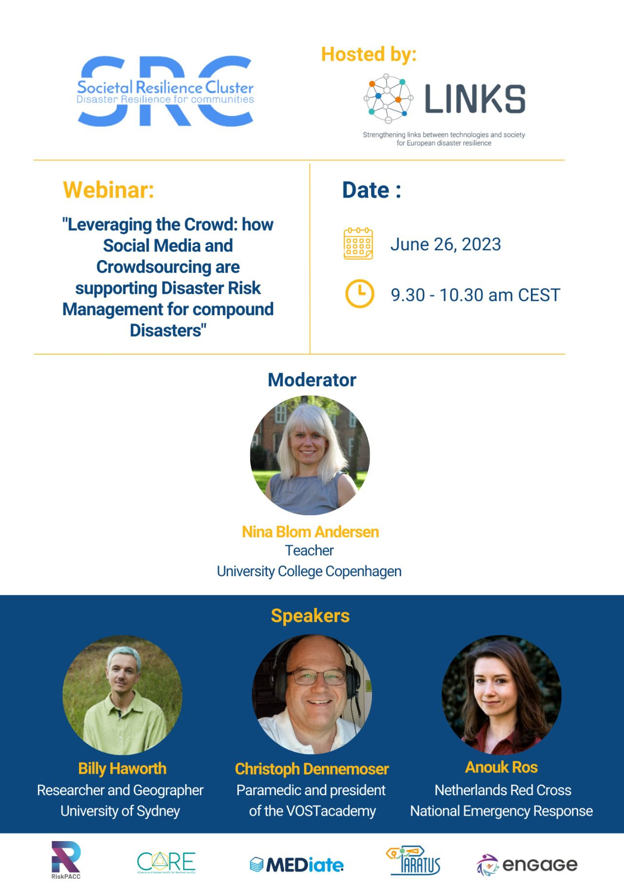
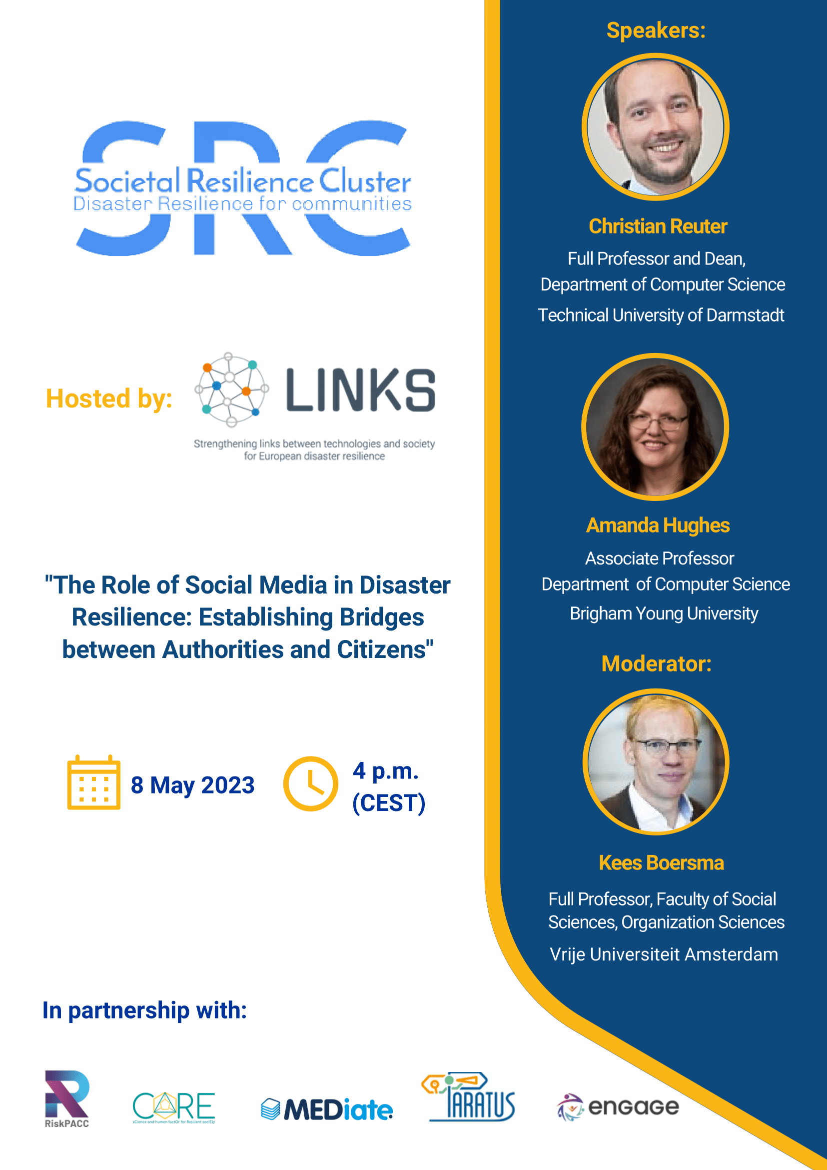
Online Webinar: Integration of Social Media Information with Legacy Platforms

The Role of Social Media in Disaster Resilience: Integration of Social Media Information with Legacy Platforms.
Webinar will take place on 7 September at 4.30 p.m. CEST.
The Societal Resilience Cluster of Horizon Projects is launching a series of webinars in 2023 on topics which focus on the strengthening of European disaster and crisis resilience.

Full details can be seen in the attachment and please register using the link:  https://www.cmine.eu/events/122304


The INFORM report 2023: understanding global crisis risks and key priorities

The INFORM 2023 report emphasizes a substantial rise in global crisis risk over the past decade that culminates in the past two years.

A surge in crises and their severity in 2022

In 2022, the number of crises increased by 18.5%, rising from 115 in January to 136 in December. During the same period, the global average severity score of active crises saw a slight decrease due to the low severity of several new crises.
Ten crises, including the drought in Kenya, violence in Sudan's Darfur and Kordofan regions, the conflict in Ukraine, and cyclone seasons in Madagascar and Mozambique, started or deteriorated in 2022. Displacement situations also worsened, particularly in Costa Rica, Ecuador, Libya, and Malaysia.
Looking ten years back from 2022 (using the INFORM Risk tool), the report also finds that there has been a global increase in the risk of humanitarian crises. Despite improvements in coping capacity, however they were not enough to keep pace with the large increases in the number of people exposed to hazards and their vulnerability .

Climate change and socio-economic trends

Climate change and socio-economic changes are expected to continue increasing the risk of crises.  Low-income countries in Africa, Central and South America, and Western and Southern Asia will likely be most affected. 
INFORM Climate Change – a specific INFORM tool - looks at the future risk of crisis taking into account two scenario combination  that represent significantly different possible futures. These are considered plausible by researchers and are referred to as the optimistic and pessimistic scenarios for greenhouse gas emissions and socio-economic development. 
Under the pessimistic scenarios , the results show more than 1.6 billion people might live – by 2050 - in countries with large increases  in the risk of humanitarian crises and disasters. Even in more optimistic scenarios, the number of people impacted by crises and the associated aid costs will significantly increase by 2050.

Looking ahead and anticipating crises

The 2023 INFORM report underscores the importance of proactive actions and strategic investments on climate mitigation, climate adaptation, disaster risk reduction and sustainable development , especially for regions that have struggled to reduce crisis risks in the past and will have even more difficulties to cope with the impact of climate change and socio economic trends. 

The report highlights the need for a global collaborative effort to build resilience and reduce vulnerability, particularly in low and lower-middle income countries if they don’t (have the means to) reduce risk. 

By leveraging the insights and data from the INFORM Report, countries, humanitarian organizations, and stakeholders can make informed decisions, prioritize resources, and implement effective strategies to mitigate future risks. Actions in climate mitigation, climate adaptation, disaster risk reduction and sustainable development are essential.

 
New report shows the potential impact of climate change on flood risk in europe, with a focus on the insurance industry

A recent study conducted under the European Union's PESETA IV project explored the potential effects of climate change on river flooding and the associated damage across Europe. 

The researchers have employed a method of refinement that involves statistical modelling of the predicted changes in damage, based on fluctuations in the Global Mean Surface Temperature (GMST). 

By making certain assumptions, these predictions can be used to estimate how much damage might vary between any two periods of time for any given GMST scenario. This information can then be used to modify many of the metrics that insurance companies use to measure flood risk, such as average annual losses, exceedance probabilities, and yearly loss tables.

The study shows how quickly or slowly the predicted flood damage changes in response to changes in the Global Mean Surface Temperature (GMST). For example, if the GMST increases by 1 degree, the rate of change shows how much the predicted flood damage is expected to increase or decrease. This is valuable information that insurance companies can use to adjust their risk models and financial forecasts.

Link to original article

 
New Tool Measures Vulnerability to Disasters in Europe

A new, cross-scale vulnerability indicator, was developed for European disaster risk assessment. The indicator provides insights into regions' susceptibility to disasters at different administrative levels.

The report "Measuring Vulnerability: Cross-Scale Approach for European Disasters" highlights vulnerability's significance in assessing disaster risk and emphasizes reducing vulnerability as an opportunity to mitigate disaster impacts.

The composite indicator consists of four dimensions: social, economic, political, and environmental. It captures vulnerability to disasters across administrative levels (Country, NUTS2 and NUTS3), facilitating a comprehensive understanding of vulnerability in Europe and allows its monitoring over time.

The vulnerability index, derived from the indicator, integrates the four dimensions within a multi-level framework. The report utilizes data from the Disaster Risk Management Knowledge Centre (DRMKC) Risk Data Hub (RDH), supporting disaster risk assessment in Europe.

 The report explains the theoretical framework of vulnerability, discusses measurement approaches, and presents sub-indices at regional and national levels.

Visual maps – as well as an interactive dashboard - illustrate vulnerability distribution across Europe and its evolution over time. Mediterranean and Eastern European countries display higher vulnerability, but variations exist within each country at the sub-national level.

The development of this vulnerability indicator can provide a very relevant contribution to effective disaster risk management and resilience-building efforts. It can provide decision-makers with essential information for prioritizing risk reduction measures.

For more information, access the full report or explore the interactive dashboard.

Link to original article

 
An innovative dataset and method to map changes in built-up areas

The Joint Research Centre (JRC) released a new dataset - the European Settlement Map ESM_2018. Its new methodology enhances the description of human settlements at a spatial resolution of 2 meters for EEA-39 countries. This innovative dataset greatly improves the capacity to map and monitor buildings and changes in built-up areas across Europe.

This 2018 settlements map combines remote sensing technology and artificial intelligence to deliver the most detailed geospatial data on built-up areas consistent across Europe. It monitors changes in built-up areas in the period 2012-2018, by identifying newly constructed residential and non-residential buildings.

Cloud cover and shadows are no longer a challenge under this fully automated image classification method that was validated using detailed building footprints for 14 areas of interest. The 2018 model outperformed existing built-up products both in terms of delineation of built-up areas and in detecting changes. 

This is a powerful data for urban planners, policymakers, and researchers and for applications requiring precise and fine representation of built-up areas and their typologies. These developments can support evidence-based decision-making around the fields of population dynamics, migration, risk management and sustainable urbanization.

Link to the data on JRC open data catalogue:
https://data.jrc.ec.europa.eu/dataset/192530fc-3d09-4740-8c1d-d1e601cdfdcc

Link to original article

 
Online Webinar "Leveraging the Crowd: How Social Media and Crowdsourcing are Supporting Disaster Risk Management for Compound Disasters"

Register for the second webinar of the webinar series of the Societal Resilience Cluster Horizon Projects hosted by LINKS EU Project: https://www.cmine.eu/events/117052

"Leveraging the Crowd: How Social Media and Crowdsourcing are Supporting Disaster Risk Management for Compound Disasters."

26 June - 9.30 a.m. (CEST)

Speakers: Billy Tusker Haworth, Christoph Dennenmoser, Anouk Ros
Moderator: Nina Blom Andersen

 
Impacts of climate change on defence-related critical energy infrastructure

This study, which for the first time addresses the climate change-energy-defence nexus, provides a set of concrete recommendations for defence decision-makers on climate change mitigation and adaptation. To achieve this, it assesses the impacts of climate change on defence-related critical energy infrastructure, military infrastructure and military capabilities, identifies options to strengthen climate resilience and multinational collaboration, while contributing to the EU’s efforts towards climate neutrality by 2050. The study was produced within the context of the third phase of the Consultation Forum for Sustainable Energy in the Defence and Security Sector to support the efforts of EU ministries of defence to strengthen climate resilience, particularly with respect to disruptions associated with defence-related critical energy infrastructure. The study contributes to the implementation of the EU’s Climate Change and Defence Roadmap and supports the development of national strategies by EU Member States to prepare the armed forces for climate change, as called for in the EU’s Strategic Compass for Security and Defence.

Link to original article

 
Risk of humanitarian crisis: INFORM’s new mid-term update

INFORM products support decision-making on humanitarian crises and disasters, contributing to decisions at different stages of the disaster management cycle, specifically climate adaptation and disaster prevention, preparedness and response. A new mid-term update includes changes in indicators and the addition of new ones. 

Updates to INFORM’s operational products 

INFORM suite includes three operational products; INFORM Risk, INFORM Severity and INFORM Climate Change, while INFORM Warning is in development. 

INFORM users include organisations from the humanitarian and development sector, donors, and technical partners. The World Bank, the World Food Programme (WFP), the United Nations Office for the Coordination of Humanitarian Affairs or the OECD are some notable examples.

These users – and everyone else looking for a global tool to understand the risk of humanitarian crises and disasters – can now use an updated version of INFORM Risk product. It now uses +80 indicators to measure hazards and the population exposed to them, vulnerability and the resources available to help people cope.

New and updated indicators lead to new risk scenarios

The INFORM Risk Index creates a risk profile for every country with scores for risk assessment and all components ranging between 0 and 10. 

In this new version of INFORM Risk 2023, the formulas to calculate indicators such as urban population growth, mortality rate under-5, humanitarian aid (FTS), development aid (ODA), people affected by disasters, internally displaced persons, refugees and asylum-seekers by country of asylum, among others, have been updated. 

When comparing the numbers from INFORM Mid 2023 with the previous ones it is still to note that Risk in Nigeria increased due to increases in floods, storms, droughts and epidemics. The same is true for Türkiye because of the rise in the number of people affected by and internally displaced by the earthquakes. The flash floods and tropical cyclones also increased the risk score in Dominican Republic.

Other comparisons and/or different data retrievals and analyses can be done through the INFORM webpage.

Link to original article

 
Risk Reduction Hub

On 18 and 19 May 2023, the General Assembly will conduct a high-level meeting on the Midterm Review of the Sendai Framework for Disaster Risk Reduction (HLM MTR SF). As per General Assembly resolution A/RES/76/204, the high-level meeting shall consist of an opening segment, a plenary segment, interactive multi-stakeholder panels and a closing segment. The process leading up to the HLM MTR SF and the report on the midterm review of the Sendai Framework (MTR SF) has included rich contributions from Members States, civil society, parliamentarians, the private sector, the scientific community and a large cross section of stakeholders at the national, regional and global levels.

UNDRR is coordinating a Risk Reduction Hub on the margins of the official sessions of the HLM MTR SF to include an array of side events and thematic engagements of various formats in order to discuss advancing risk reduction efforts across sectors, regions, and contexts. These events are for governments, experts, and stakeholders, including and beyond traditional disaster risk reduction actors, to discuss how the calls to action contained in the Political Declaration can be taken forward and to offer concrete solutions that can be the genesis of initiatives or coalitions emanating from the MTR SF

Link to original article

 
Droughts in Europe: an exceptionally dry and warm winter affects the south and west of the EU

The Joint Research Centre (JRC) of the Commission has published a new report on the drought situation in Europe. It shows that most of the southern and western countries of the European Union are affected by drought and that water supply, agriculture and energy production can be under threat.

Due to an exceptionally dry and warm winter, soil moisture and river flow are already showing significant anomalies, especially in France, Spain and northern Italy. In the Alps region, the snow accumulation was well below average and is even lower than in the winter of 2021-2022. This will lead to a sharp reduction in the contribution of snowmelt to river flows in the perialpine region in spring and early summer 2023. Spring rainfall will be crucial in determining the evolution of the current drought and its impacts. 

Europe and the Mediterranean region could experience an extreme summer this year, similar to 2022. The report recommends close monitoring and appropriate use of water as well as the implementation of targeted sectoral adaptation strategies and an enhanced cooperation, as these climate and weather models are expected to be more frequent in the future. 

The JRC produces real-time drought information through the European and Global Drought Observatories (EDO and GDO), which are part of the Copernicus Emergency Management Service (CEMS)

Link to original article

 
Host your local and EU disaster risk and loss data in the Risk Data Hub

The Risk Data Hub (RDH) is a GIS web-based collaborative platform used to look up, host, and share disaster risk and loss data – crucial information to support disaster risk prevention and risk management. 

Recently, three new Users Corners were established as a result of successful collaborations facilitated by the platform. The platform's "User Corner" service accommodates and disseminates results related to external projects, mainly addressing national authorities. It offers a flexible and customized solution for accessing, storing, and managing losses and risk data that serves policy access well.

The Flood Fatalities for territories in Euro-Mediterranean (FFEM) region database exhibits the number of fatalities and extensive information about the profile of victims and the accident circumstances across 12 study areas. Achieving this necessitated the inclusion of Turkey and Israel, extending beyond the platform's study area. These countries exemplify the platform's continuous expansion and development, as they are the first non-EU countries to be included.

Another User Corner is the Alicante Province Economic Losses database, which hosts loss data provided by the Spanish National Insurance System. Losses are expressed in terms of compensation pay-outs of insured assets damaged by Flash Floods in the past 25 years.

Finally, the new European Central Bank -Physical Risk shows a set of indicators developed by the European Central Bank (ECB) which take into account risks stemming from climate-change-induced natural hazards that can affect the performance of financial institutions of the Euro area. This “corner” with financial information shows that the platform can host data beyond the field of disaster risk management.

Finally, the new European Central Bank - Physical Risk is a recent addition that presents a series of indicators developed by the European Central Bank (ECB) which consider the risks associated with climate-change-induced natural hazards that may impact the performance of financial institutions in the Euro area. This financial information \"corner\" demonstrates that the platform is capable of accommodating data beyond the realm of disaster risk management.

Additional information on these three external projects now hosted in the Risk Data Hub is available in the dedicated page of each User Corner. If you explore the Risk Data Hub and you want to create a dedicated user corner where your data can be saved, returned to and worked upon, get in touch with the Joint Research Centre’s development team.

Users can find information concerning the three external projects now housed in the Risk Data Hub on the respective dedicated pages of each User Corner. If you navigate through the Risk Data Hub and wish to establish a dedicated \"user corner\" for saving, revisiting, and working with your data, contact the Joint Research Centre's development team.

Link to original article

 
River flood risk is increasing: what are the best adaptation measures to protect lives and save assets?

New research co-developed by scientists from the Joint Research Centre of the European Commission and published in Nature Climate Change compares the costs and benefits of flood risk reduction measures in Europe. 

The study estimates that in the European Union and UK river flooding currently causes annual damage of about €7.6 billion and exposes around 160 000 people/year to inundation. In a 3°C global warming scenario and without climate change adaptation, flood damage in Europe would rise to €44 billion per year, exposing nearly half a million Europeans every year until the end of the century. 

As a result, flood adaptation is crucial to offset rising river flood risk in Europe with climate change and scientists point out it can be cost-effective. Creating water detention areas, building river dykes, floodproofing buildings, and relocating people and assets are key flood adaptation measures. These measures can considerably lower projected flood losses in Europe until 2100 in all the 3 scenarios of global warming - 1,5°C, 2°C and 3°C - assessed.

A combination of different measures optimised at the level of river basins are likely the best way to maximise local benefits and minimise the drawbacks of each action. Reducing flood peaks using detention areas is economically the most attractive option: each euro invested would save four euro in avoided damages (in a 3°C warming scenario). 

Strengthening existing dyke systems is also cost-effective in most countries of Europe, but with considerable variation between countries in risk reduction potential and cost-benefit ratios. Despite being less economically attractive, adaptation through building floodproofing and relocation can help reduce impacts in areas frequently hit by floods, or with a high concentration of people or valuable goods.

Link to original article

 
The Science behind the EU’s response to the earthquakes in Türkiye and Syria

The European Commission’s Joint Research Centre (JRC) and the Emergency Response Coordination Centre (ERCC) have supported decision-making at political and ground levels since day one by providing an integrated scientific perspective and updated information. 

Thirty-two minutes after the first earthquake, the Global Disaster Alert and Coordination System released a red alert, indicating the need for international assistance to cope with a major disaster. Türkiye contacted the ERCC, which then activated the Union Civil Protection Mechanism and Copernicus Emergency Management Service (CEMS) and requested Urban Search and Rescue teams. The ERCC highlighted the needs, based on which the JRC’s Disaster Risk Management team produced several emergency reports.

Later, ECHO Daily Maps (see image) were developed to inform about the impact and response to the event, based on needs highlighted by the ERCC.


These reports highlighted potential or existing damage to the built environment, dam breaking, migration consequences, misinformation trends, and health situations in the affected areas. The reports also featured work by the Social Media for Disaster Risk Management (SMDRM) AI algorithm, which processed more than a million Twitter messages to identify those requesting help. Less than 48 hours later, CEMS delivered the first maps of the event, identifying the affected infrastructure, flood-prone areas, and the location of humanitarian camps. 

Less than 48h CEMS started delivering the first maps of the event, identifying the infrastructure - buildings, dams or gas or oil pipelines - affected. Other maps showed the situation in flood-prone areas or the location of humanitarian camps. 

Additionally, the CEMS Drought Observatory reported that Türkiye and the Maghreb region are under warning drought conditions, which may worsen water availability for agriculture and energy. The JRC continues to provide science-based evidence to support European Commission efforts and contributions to this emergency.

Link to original article

 
Highlights from the Global Flood Forecasting and Monitoring Meeting 2023

On 8 and 9 February 2023, the Copernicus Emergency Management Service (CEMS) organised the 2nd Global Flood Forecasting and Monitoring Meeting, held online.
More than 500 participants attended the event over the two days. It brought together professionals and researchers in flood forecasting and monitoring to discuss the latest advances in the field. The workshop was highly interactive, with several sessions focused on the latest developments of the Global Flood Awareness System (GloFAS) and the Global Flood Monitoring (GFM) tool. The speakers and the participants also discussed about data access, use cases, applications, and their contribution to the United Nations #EarlyWarning4All initiative.
Two IGNITE Talks sessions were organised, providing the opportunity for 13 representatives of related initiatives to introduce their use cases and experiences using GloFAS and/or GFM data.
Finally, the workshop format included interactive discussions, booths, and poster presentations in Gather.Town, a new web-conferencing software allowing participants to connect with other community members while moving in an innovative and interactive virtual environment.

Link to original article

 
OCHA Centre for Humanitarian Data Event - Quantifying climate change risk in humanitarian response

The event will present recent research into the future impacts of climate change on humanitarian crises
and discuss how we can respond to them. Specifically, it will present findings from INFORM Climate
Change Index, which provides quantified estimates of the impacts of climate change on the future risk of
humanitarian crises. The event will then examine how humanitarian donors and organisations can use
this kind of data and information to support operational and policy responses to the humanitarian
climate emergency.

Link to original article

 
CERIS Workshop: “Methods and examples of piloting and validation of innovative border management solutions”

This CERIS Workshop aims to discuss methodological approaches, successes and challenges for piloting and validation of innovative border management solutions; share experiences on piloting and validation; identify features of piloting and validation at different TRLs; and define relevant recommendations. Activities at both research and innovation levels will be presented.

Link to original article

 
COP27 EU Side Event: Drought: a Global Challenge

In the framework of the COP27 conference in Sharm-el-Sheikh under the Presidency of Egypt, the European Commission organised more than 120 Side Events from 7 to 18 November 2022.

One of these was the thematic side event on drought, in the aftermath of the 2022 extreme drought episode in Europe. As highlighted in its title, Europe is not the only region which has been affected by such an extreme event. Indeed, the Global and European Drought Observatories (GDO and EDO) have released a series of reports throughout the year detailing the drought episodes affecting many areas of the globe: Europe (with focused reports on the Western Mediterranean, Northern Italy, and the Netherlands), Eastern Africa (with focused reports on Somalia, Kenya, Tanzania, and Ethiopia), and China. South America continues to experience- since 2019 one of its worst droughts and an updated report on the situation in the La Plata Basin and its impacts is in preparation. 

Furthermore, in the coming decades, drought events are expected to be more frequent, affect larger areas and become more severe, affecting key socio-economic sectors and ecosystems, often triggering cascading effects

Link to original article

 
COP27 EU Side Event: Data and systems for understanding and acting on current and future risks

This 1-hour event organized by DRMKC will be focused on building the evidence base to inform future action on disaster risks. Together with amazing guest panellists from the Joint Research Centre, the European Central Bank, ESPON ,TECNALIA, UN OCHA and DG ECHO, we will discuss:
- Vulnerability assessment for a better understanding of disaster losses and impacts 
- How to embed climate change risks and impacts in financial risk analysis 
- The links between climate change monitoring systems and humanitarian action 
You can register here to this session and check other interesting talks – such as the global drought session – by following this link.

 
FLASH NEWS - October 2022: International Day for Disaster Risk Reduction (IDDRR)

Science for “Early warning and early action”
This year the International Day for Disaster Risk Reduction (IDDRR) campaign will focus on “Early warning and early action for all” and, in particular, on Target G of the Sendai Framework: “Substantially increase the availability of and access to multi-hazard early warning systems and disaster risk information and assessments to people by 2030”. This special issue of the FLASH NEWS from the Disaster Risk Management Knowledge Centre shares an overview of the recent research and activities of the European Commission that directly or indirectly contribute to the availability of risk information/assessments and to the delivery of early warnings for everyone.

More information here


Link to original article