Archive:Agricultural census in Italy
This article has been archived.
This article is part of a series of country-specific essays on the results of the European Union (EU) Farm structure survey (FSS) 2010. The FSS collects information on the structural characteristics of the agricultural holdings (land use, livestock and labour force) and is carried out by all European Union Member States every 10 years as an Agricultural census, with two or three additional, intermediate sample surveys carried out in-between. In Italy, the present analysis of the farm structure includes a comparison with the previous (2000) Agricultural census.

Source: Eurostat (ef_kvaareg) (ef_ov_kvaa) (demo_pjan) and FSS 2000 and 2010

Source: Eurostat (ef_kvaareg) (ef_ov_kvaa) and FSS 2000 and 2010

Source: Eurostat (ef_kvaareg) (ef_ov_kvaa)
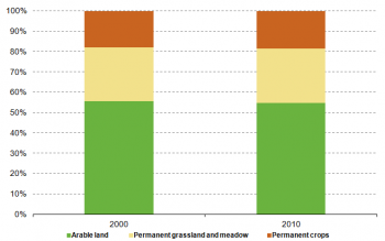
Source: Eurostat (ef_lu_ovcropaa) (ef_oluaareg)
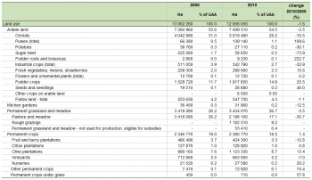
Source: Eurostat (ef_lu_ovcropaa) (ef_oluaareg)
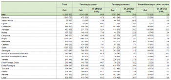
Source: Eurostat (ef_mptenure)

Source: Source: Eurostat (ef_pmhouscatlaa)
Main statistical findings
Key indicators
In 2010, there were 1 620 880 agricultural holdings in Italy (see Table 1); a value which was found to be the second highest within the EU-27, after the one recorded in Romania. Since the number of holdings recorded in 2000 was 2 396 274[1], after the year 2000 roughly one out of three farms ceased its activity in Italy.
Also in terms of utilised agricultural area (UAA), Italy recorded one of the highest values among the EU Member States: 12.9 million of hectares, accounting for 43 % of the whole territory. Nonetheless, compared to the FSS 2000 – when it reached 13 million hectares – the agricultural area decreased slightly (-1.6 %). As the number of holdings dropped faster than the agricultural area within the 2000-2010 time frame, the average size of the farms increased (+45 %), changing from 5 ha in 2000 to 8 ha in 2010, a value which remains among the smallest recorded within the EU-27.
An opposite tendency characterised the average agricultural area per inhabitant, which decreased moving from 0.23 ha in 2000 to 0.21 ha in 2010. Indeed, over the period under analysis, the Italian population grew (+6 %) while the UAA slightly decreased (-1.6 %).
The animal livestock – expressed in livestock units (LSU) – remained rather constant over the inter census decade: 10 million LSU were recorded in 2000 while 9.9 were surveyed in 2010 (-0.6 %). Accordingly, despite falling right below the 10 million threshold, Italy was among the EU Member States with the largest animal livestock in 2010.
Similarly to most of the EU Member States, also in Italy the number of persons working in agriculture dropped between 2000 and 2010 (-14 %), from 4 million to 3.4 million. Nonetheless, in 2010 the Italian agricultural labour force was one of the biggest within the EU-27 and still represented 14 % of the Italian economically active population.[2]
Regional key indicators
The regional analysis of the key indicators (see Table 2) allows to detail the structure of the Italian farms. In terms of agricultural area, Sicily recorded the highest share: in 2010, it recorded 1.4 million hectares, accounting for 10.8 % of the agricultural area of the whole country (+10.4 % compared to the value registered in 2000). Another southern region, the territory of Puglia, recorded the second highest share (10 %), corresponding to 1.3 million hectares of agricultural area: +5.1 % compared to the 2000 value. With an increase of 14 % over the 2000-2010 time frame, the island of Sardegna is the territory which recorded the highest growth in terms of agricultural area: it moved from 1 million hectares of UAA to 1.1 million, thus accounting for 9 % of the Italian UAA in 2010. Although both Piemonte (1 million ha) and Emilia-Romagna (1.1 million ha) recorded remarkable values in 2010, in both cases a reduction was reported in comparison with 2000: -5.4 % for the former region, -4.5 % for the latter one.
In terms of the animal livestock, the northern regions proved to be more important than the southern ones in Italy. Indeed, Piemonte, Lombardia, Veneto and Emilia-Romagna accounted together for 64 % of the country’s LSU in 2010. With 2.7 million LSU – a 28 % share over the total population – Lombardia proved to be the most important territory and recorded a +6.7 % growth compared to the FSS 2000. Despite the fact that it registered a -8.2 % drop over the 2000 figure, Veneto recorded the second highest value: 1.4 million LSU, accounting for about 14 % of the total LSU population. Within the 2000-2010 time frame, figures dropped also for Emilia-Romagna (-7.3 %); nonetheless 1.2 million LSU were recorded on its territory in 2010, a value corresponding to the 12 % of the whole national livestock. With a 10 % share of the livestock population, Piemonte recorded the smallest double digit percentage. In 2010, it accounted for 1 million LSU, a value which represented an increase of 2.3 % compared to 2000.
If the labour force is taken into account a very opposite tendency is observed, as the southern regions showed the highest number of persons working in the farms in 2010. With about 560 000 persons employed in agriculture, the south eastern territory of Puglia recorded the highest figure: a value which accounted for the 16.5 % of the total regular labour force and corresponded to a 6 % increase compared to 2000. Despite recording a decrease of 13 % compared to 2000, Sicily scored the second highest share (12.7 %), corresponding to about 430 000 units. Very similar were the values recorded for Calabria (280 110 persons; 8.3 % of the regular labour force) and Campania (279 670; 8.2 %), in the first case a 7.4 % increase was registered whereas values dropped by 31 % for the latter one.
Finally, although the employment of different thresholds in the two reference years biases the comparison between the respective holding populations, it can be suggested that all the regions were affected by the fall in the number of agricultural holdings.
Agricultural holdings
As already observed in most of the EU Member States, between 2000 and 2010 a tendency for the small farms to disappear in favour of the bigger ones was reported also in Italy. Accordingly, the population of agricultural holdings with less than 20 hectares of land decreased (-34.6 %). On the contrary, all the other classes of farms grew, with the highest growth recorded among the biggest class of farms, those with 100 hectares or more of UAA (+23 %). Agricultural holdings with 50 to 99.9 ha of agricultural land scored the second highest increase (+22 %), while farms with 30 to 49.9 hectares grew by 11.5 %. The only exception to this tendency was represented by farms with no agricultural area, as their number almost doubled over the decade under analysis, moving from 3 480 in 2000 to 5 290 in 2010.
As a result of this transformation more than half of the Italian UAA currently belongs to a very small number of farms (see Figure 1), those with 30 or more hectares of agricultural land, which accounts for only 5 % of the total population of farms. On the contrary, the majority (51 %) of agricultural holdings proved to belong to the smallest class of farms with UAA. Indeed, 819 360 farms were recorded as having between 0.1 ha and 1.9 ha of agricultural land.
The average size of the holdings proved to change largely depending on the region. Indeed, Sardegnia (19 ha), Lombarida (18.2 ha), Valle d’Aosta (15.7 ha) and Piemonte (15.1 ha) recorded values largely over the country’s average which indicated the value of 7.9 hectares in 2010. On the other hand, the regions of Liguria (2.2 ha), Campania (4 ha) and Calabria (4 ha) displayed values well below 7.9 hectares.
See detailed data at NUTS 2 level for 2010 (ef_olsaareg) and 2000 (ef_ov_kvaa)
Economic size of the farm
In terms of economic size, Italian agricultural holdings recorded the second highest value within the EU-27 in 2010: EUR 49 460 million (see Table 3). This figure – calculated by adding all the standard output (SO) per hectare of crop and per head of livestock of the farms – represents a 22 % increase compared to the FSS 2007 data (EUR 40 540 million).
The economic size of the farms seemed to vary largely depending on the region. Accordingly, the northern territory of Lombardia recorded the highest value: EUR 7 388 million of SO, corresponding to 15 % of the country’s total SO. Emilia-Romagna recorded the second highest figure – EUR 6 367 millions – accounting for 13 % of the SO of the Italian farms, whereas Veneto scored the third highest percentage (11.1 %), corresponding to EUR 5 505 million. Furthermore, the island of Sicily accounted for 8.8 % of the country’s SO, recording a value of EUR 4 335 million in 2010.
At the other end of the scale, with EUR 58 millions of SO, the mountainous region of Valle d’Aosta recorded the smallest share 0.1 %, while the neighbour territory of Liguria recorded the second smallest percentage (0.7 %), corresponding to EUR 369 million.
See detailed data at NUTS 2 level for 2010
Agricultural holding by main type of farming
In terms of the main area of production, in 2010 farms specialised in olives were found to be the most common in Italy (see Figure 2). According to the FSS 2010, they accounted for about 28 % of the total number of agricultural holdings. The second most common type of production proved to be cereals, oilseed and protein crops, which accounted for 13 % of the total population of farms in 2010. Furthermore, agricultural holdings specialised in vineyards shared another 13 %, a value slightly higher than the one recorded by holdings dedicated to general field cropping (11 %).
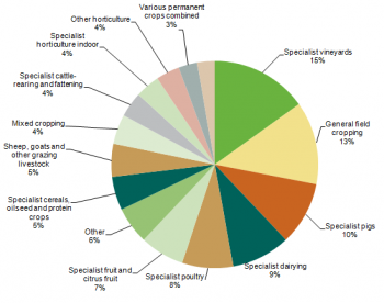
If the economic size of the farms is taken into account, the hierarchy of the holdings changes. Indeed, when using the standard output (SO) for measuring the main type of farming, only three categories of production reached a double digit percentage. In particular, holdings specialised in vineyard proved to be the most important (15 %); the second highest contributions came from holdings dedicated to general field cropping (13 %), while the farms dedicated to pigs accounted for 10 %. Furthermore, farms specialised in dairying accounted for 9 % of the total standard output, whereas those specialised in poultry shared another 8 %.
See detailed data at NUTS 2 level for 2010
Land use
The utilised agricultural area (UAA) is the total area taken up by arable land, permanent grassland and meadow, permanent crops and kitchen gardens used by the holding, regardless of the type of tenure or of whether it is used as a part of common land.
In Italy, the UAA decreased by 1.6 % over the 2000-2010 time frame – a fall of about 206 000 hectares in absolute terms – indicating the value of 13 million ha in 2010.
As already observed in most of the EU Member States, the relative importance of the main components of the Italian agricultural area did not change much over the decade under analysis. Accordingly, the arable land remained the most important element, accounting for more than half of the country’s UAA, even though its share decreased from 55.6 % in 2000 to 54.5 % in 2010 (-3.5 %). In 2010, permanent grassland and meadow accounted for about one fourth of the whole agricultural area, as it did in 2000, while the share of permanent crops moved from 18 % in 2000 to 18.5 % in 2010 (+ 34 000 hectares).
See detailed data at NUTS 2 level for 2010 and 2000
Arable land
In Italy, the land worked (ploughed or tilled) regularly, generally under a system of crop rotation, decreased by 3.5 % (- 251 650 hectares) within the 2000-2010 decade (see Table 4). Within the arable land, cereals and fodder crops were found to be the two main categories of production: in 2010 they accounted together for 43.1 % of the Italian UAA. Over the 2000-2010 decades, the production of cereals decreased its share over the total hectares of arable land, moving from 31 % in 2000 to 28.2 % in 2010 (-423 500 hectares). On the other hand, fodder crops gained importance over the years as their production moved from 11.7 % in 2000 to 14.9 % in 2010: +389 130 hectares in absolute terms.
See detailed data at NUTS 2 level for 2010 and 2000
Permanent grassland and meadow
The area of permanent grassland and meadow remained rather stable over the years, indicating the value of 3.4 million hectares in 2010. Nonetheless, it must be noted that due to a change in the methodology, in 2010 two additional categories – not employed in the FSS 2000 – were used for the classification of the permanent grassland and meadow. In particular, 1.2 million hectares of UAA (9.2 %) were classified as rough grazing in 2010.
See detailed data at NUTS 2 level for 2010 and 2000
Permanent crops
The structure of the area of permanent crops did not change considerably over the decade under analysis. Accordingly, olive plantations recorded the highest value over the total UAA both in 2010 (8.7 %) and 2000 (7.6 %), while vineyards confirmed their importance, as they recorded a share of 5.5 % in 2000 and one of 5.2 % in 2010.
See detailed data at NUTS 2 level for 2010 and 2000
Livestock
Statistics on livestock use two different units of measurement, the livestock units (LSU) and the number of heads (number of animals) – the former allows comparison between species.
According to the Agricultural census 2010 (see Table 5), there were about 9.9 million LSU in Italy, whereas there were roughly 10 million in 2000 (-0.6 %). Furthermore, 0.16 LSU per inhabitant were recorded in 2010. Since the year 2000, the Italian population increased (+6 %) while the animal livestock remained rather stable (-0.6 %), as a result the number of LSU per inhabitant recorded in 2000 was slightly higher (0.18).
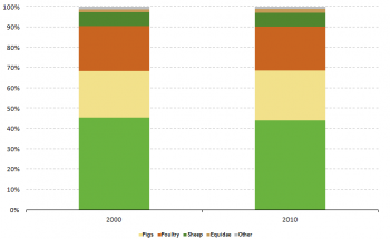
In 2010, 90 % of the Italian livestock population consisted of cattle (44 %), pigs (24.8 %) and poultry (21.6 %). In absolute terms, cattle accounted for 4.4 million LSU and recorded a decrease of 3.6 % over the FSS 2000 value; pigs indicated the value of 2.5 million LSU and a +6.7 % growth compared to 2000; poultry recorded 2.1 million LSU, and a fall of 2.5 % compared with 2000.
In relative terms, the territory of Lombardia proved to be the most important among the Italian regions, as it accounted for 28 % of the animal livestock in 2010: in terms of LSU, it contributed to 12.4 % of the total livestock of pigs and 11 % of the cattle population. According to the FSS 2010, Veneto was the second most important territory, accounting for 14 % of Italian LSU (1.4 million LSU), while Emilia-Romagna was the third one hosting 1.2 million LSU, corresponding to a share of 12 %.
Within the 2000-2010 time frame, the number of agricultural holdings with livestock decreased drastically (-65 %), from 627 200 to 217 330. Accordingly, the relative weight of the farms with livestock over the total population of agricultural holdings decreased, from 26.2 % in 2000 to 13.4 % in 2010. With the exception of the bigger class of farms – those with 500 or more LSU, which recorded a +9 % growth – all the categories of holdings with LSU registered drops, with the smallest size classes scoring the highest falls. The territory of Marche is the one which recorded the largest decrease (-83 %).
See detailed data at NUTS 2 level for 2010 and 2000
Labour force
In 2010, 3.4 million persons were employed in the agricultural holdings (see Table 6). This value, one of the highest recorded within the EU Member States, represents a 14.4 % decrease compared with 2000, when about 4 million persons were regularly employed. The decrease appears even sharper if the annual work unit (AWU) is taken into account; in this case the labour force fell by 30.3 %, from 1.2 million AWU in 2000 to about 842 000 AWU in 2010.
Among the sole holders, the gender distinction appeared to be marked and stable over the years as 77 % of sole holders proved to be male in both reference years.
See detailed data at NUTS 2 level on holders' age and gender for 2010 and 2000
See detailed data at NUTS 2 level on type of labour force for 2010 and 2000
Management practices
Type of tenure
According to the Agriculture census 2010, In Italy the majority of the agricultural area was owned by the farmers who actually worked on that land (see Table 7): 8.3 million hectares, corresponding to 65 % of the Italian UAA. The highest share was registered in Puglia, where about 83 % of the agricultural land (1.1 million ha) was farmed by the owner. On the other hand, Valle d’Aosta was the region which showed the smallest share of land under this category (18.6 %). Piemonte and Lombardia, two of the most important regions in terms of agricultural production, showed a different tendency as in both territories the category farming by the owner was not prevalent: in the first case it recorded the 47 %, whereas 46.3 % was the share of the latter one.
In Italy, the second most common type of tenure was farming by the tenant, it accounted for 29.5 % of the total agricultural area (3.8 million ha). Among the different regions, Valle d’Aosta showed the highest percentage (80.8 %), though the values recorded for Lombardia (49 %) and Piemonte (47.7 %) were also remarkable.
The agricultural area utilised in partnership by the landlord and the sharecropper under a written or oral share-farming contract, or the area utilised under other modes of tenure, was found to be relatively small (717 820 hectares) and accounted for 5.6 % of the whole UAA.
Irrigation
Within the 2000-2010 time frame, the total irrigable area decreased by 3.1 % in Italy – it moved from 3.8 million ha to 3.7 million ha. Hence, in 2010 it accounted for about 29.1 % of the total agricultural area, one of the highest shares among the EU Member States. Also the area irrigated at least once a year was found to be remarkable: it covered 19 % of the Italian agricultural area and indicated the value of 2.4 million hectares in 2010.
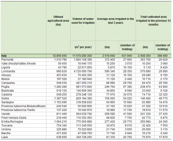
The analysis of the quantity of water used to irrigate one hectare of land gives further insight into the irrigation of the Italian UAA and provides a better understanding of the regional differences. The analysis is based on the total cultivated area irrigated in the 12 months prior to the Agricultural census and the quantity of water used in 2010 (see Table 8). It shows that the northern region of Lombardia is the most intensively irrigated, as on average 8 182 cubic metres of water were used for each hectare of its UAA. The southern region of Sicilia recorded the second highest value with 5 662 cubic metres per ha. At the other end of the scale, the region Valle d’Aosta recorded the lowest figure: 698 cubic metres per hectare of irrigated agricultural land. The Italian average could be established at 4 804 cubic metres per ha, a lower value than the one recorded in Spain (5 470).
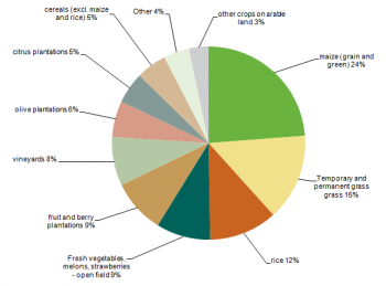
As shown in Figure 7, the harvest that had the largest share of irrigation water (24 %) was maize. Temporary and permanent grass accounted for another 15 % of irrigated area, followed by rice (12 %) and fresh vegetables, melons and strawberries (9 %), the latter having recorded the same percentage as fruit and berry plantations.
See detailed data at NUTS 2 level for 2010 and 2000
Animal housing
In 2010, there were 125 880 holdings raising 5 952 990 heads of cattle in Italy. Accordingly, the Mediterranean peninsula proved to be one of the EU Member State with the higher number of farms with cattle. As exhibited in Table 9, the majority of Italian farms (56.8 %) hosted cattle in loose housing with solid dung and liquid manure (2 943 770 places). In terms of number of holdings, the second most frequent type of animal housing was the one in which the animals are stanchion tied stable with solid dung and liquid manure (34.8 %): it accounted for 798 360 places and was recorded in 43 820 farms. When analysing the animal housing capacity, it must be noted that more than one type of housing could be recorded for a single holding.
Other gainful activities
According to the FSS 2010, 76 150 agricultural holdings proved to be involved in other gainful activities in Italy. These were farms which recorded activities other than farm work, directly related to the holding and having an economic impact on it. Although this figure represented a small portion of the Italian population of holdings (5 %), in absolute terms it was the second highest value recorded within the EU-27.
Information on other gainful activities was collected by eleven category types depending on their characteristics – each farm could be involved in more than one other gainful activity. The most common type surveyed was contractual work (21 320 farms), which was found to be mainly contractual agricultural work (19 820 holdings). Tourism was recorded for 19 300 farms, 3 490 of which (18 %) were registered in Toscana, while other 3 170 of them (16 %) proved to be located in the small territory of the Provincia Autonoma di Bolzano. In addition, processing of farms products was registered for 16 710 holdings, 2 500 of which (15 %) were located in Lombardia.
See detailed data at NUTS 2 level for 2010 and 2000
Organic farming
Organic agriculture is an ecological production management system that promotes and enhances biodiversity, biological cycles, and soil biological activity. It is based on the minimal use of off-farm inputs and on the management practices that restore, maintain or enhance ecological harmony.
In Italy, the agricultural area in which organic farming is practiced grew steadily between 2003 and 2010. On the other hand, the number of holdings practicing organic farming showed an irregular pattern (see Table 11). Nonetheless, among the EU Member States Italy displayed the highest number of farms employing this type of farming in 2010: 41 920 holdings, corresponding to 2.6 % of the national farms population. The Mediterranean peninsula also recorded the second largest UAA under organic farming: 754 530 hectares, accounting for 5.9 % of the national agricultural area.
See detailed data at NUTS 2 level for 2010, 2007, 2005, 2003 and 2000
Data sources and availability
Methodological notes
In Italy, six Agricultural censuses have been conducted since 1961: the 2010 wave was the last one. Istat, the Italian National Statistical Institute, was the responsible body.
Survey on agricultural production methods (SAPM)
In 2010 a unique survey was carried out together with the agricultural census, the Survey on agricultural productions methods (SAPM). This survey collected data at regional level needed to establish agri-environmental indicators as indicated in COM final 508/2006 and to evaluate the greening of the Common agricultural policy.
Data were collected according to specifications listed in Annex V of regulation 1166/2008, namely data on tillage methods, soil conservation, landscape features, animal grazing, animal housing, manure application, manure storage and treatment facilities and irrigation.
In Italy, no sampling was applied to the SAPM and the survey on other gainful activities – both were conducted exhaustively together with the FSS 2010.
Reference period
Data on the FSS 2010 were collected as of the 24th of October 2010. However, information on land use, agricultural and animal production methods, labour force and other gainful activities related to the farms refer to the November 2009-October 2010 time frame.
Threshold for agricultural holdings
In Italy, regional thresholds were applied for defining the coverage of the population in 2010: they ranged from 0.2 ha to 0.4 ha, depending on the region[3] .All the farms with agricultural area equal or bigger than the regional threshold were surveyed. Furthermore, because of their economic relevance, all the holdings with flowers and ornamental plants, vegetables, vineyards and fruit trees were included in the population.
Common land
Only common land used for animal grazing was included in the Agricultural census 2010. Therefore, common land classified as wood or non agricultural area was not surveyed.
Geo-reference of the holding
Information on the location of the agricultural holdings was collected directly through the questionnaire. Both questions on the residence of the holder and on the location of the holding headquarter were asked, though the latter was only asked if the holding headquarter differed from the holder’s residence.
Economic size
Since the FSS 2007, the standard output (SO), a new classification of the economic size of the holding has been implemented. The SO has replaced the standard gross margin (SGM) used before. Nonetheless, for comparability reasons, both classifications are available in the FSS 2007.
Volume of irrigation water
The volume of water used for irrigation was estimated through a model called MARSALA. It was developed by the National Institute of Agricultural Economics (INEA) and implemented with the cooperation of ISTAT. In order to get the appropriate variables for building the model, the questionnaire on the FSS 2010 was integrated with questions referring to irrigations. In particular, three main aspects were taken into account: the crops’ irrigation need, the irrigation system efficiency and the farmers’ irrigation strategy.
Other issues
Comparability with the FSS 2000
In 2000, all the agricultural holdings with 1 ha or more of UAA – or with an output of at least EUR 2 065.83 – were surveyed. In 2010, only a physical threshold was applied: it ranged from 0.2 ha to 0.4 ha depending on the region. The change in the threshold that occurred in the two reference years has an impact on the comparability between the FSS 2010 and the FSS 2000. Indeed, using the 2010 thresholds on the 2000 data, the number of holdings estimated for 2000 is 2 396 274, whereas the number calculated with the 2000 threshold was 2 153 720 (-11.3 %). Considering that the number of holdings not taken into account by the 2000 threshold is high, the 2010 threshold was applied to the FSS 2000 dataset, when possible, to compare the number of farms between the two reference years. On the contrary, as the holdings below the 2000 threshold are all very small – they are farms that recorded less than 1 hectares of agricultural area in 2000 – the FSS 2000 data on agricultural area were not recalculated using the 2010 threshold.
In addition, within the time frame under analysis a border shift occurred between Emilia-Romagna and Marche. Although this concerns mostly the towns of Rimini, Pesaro and Urbino, the time series of the two regions involved might have been biased.
Context
European Commission Rural development policy aims to improve competitiveness in agriculture and forestry, the environment and the countryside, as well as to improve the quality of life in rural areas and to encourage the diversification of rural economies.
As agriculture has modernised and the importance of industry and services within the economy has increased, agriculture has become much less important as a source of jobs. Consequently, increasing emphasis is placed on the role farmers can play in rural development, including forestry, biodiversity and the diversification of the rural economy, in order to create alternative jobs and provide environmental protection in rural areas.
The FSS continues to adapt in order to provide timely and relevant data to help analyse and follow these developments.
See also
- Agricultural census 2010
- All articles on Italy
- All farm structure articles by country (2007)
- Farm structure statistics
Further Eurostat information
Publications
- Agriculture, fishery and forestry statistics — Main results – 2010-11 - 2012 edition
- Farm Structure Survey in Italy - 2007 - Statistics in focus 84/2009
- Farm Structure Survey in Italy - 2005 - Statistics in focus 22/2007
- Structure of Agricultural Holdings in Italy - 2003 - Statistics in focus 12/2005
Main tables
- Agriculture, see:
- Farm structure: historical data (1990-2007) (t_ef)
Database
- Agriculture, see:
- Structure of agricultural holdings (ef)
Dedicated section
Methodology / Metadata
- Farm structure (ESMS metadata file — ef_esms)
- Methodological Report – FSS 2007 Italy
- Methodological Report – FSS 2010 Italy
Source data for tables and figures (MS Excel)
Other information
- Regulation 1166/2008 of 19 November 2008 on farm structure surveys and the survey on agricultural production methods and repealing Council Regulation 571/88
- Regulation 1200/2009 of 30 November 2009 implementing Regulation 1166/2008 on farm structure surveys and the survey on agricultural production methods, as regards livestock unit coefficients and definitions of the characteristics
External links
Notes
- ↑ This figure has been estimated using the 2010 threshold. If the 2000 threshold is used on the FSS 2000 dataset, the number of units recorded is 2 153 720.
- ↑ A value calculated over the total number of active people aged 15 to 64, as it is reported by the 4th quarter 2010 of the EU Labour force survey (LFS), see (lfsq_pganws) Population by sex, age, nationality and labour status (1 000).
- ↑ More information on the population covered by the FSS 2010 as well as a table detailing all the regional thresholds can be found in the National Methodological Report (NMR): pages 24 and 25


