
Increasing our understanding of volcanic eruptions
Related topics
Environment & climate action Innovation France Germany Ireland Italy Sweden United Kingdom Iceland Switzerland Environment Norwaydate: 20/09/2014
Project: A European volcanological supersite in I...
acronym: FUTUREVOLC
See also: CORDIS
Contact: Contact
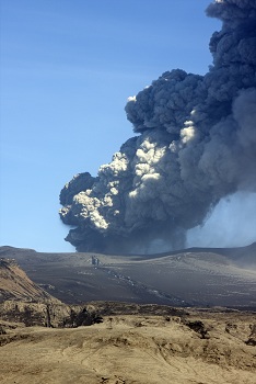
Volcanic eruptions are notoriously difficult to predict. With increased seismic activity at Iceland's Bárðarbunga volcano, and lava flowing at nearby Holuhraun, experts are carefully monitoring and analysing large amounts of data being collected from the area.
Many Icelandic volcanoes are ice-covered, a factor that often contributes to explosive, ash-rich eruptions similar to Eyjafjallajökull in April 2010. Eyjafjallajökull spewed large ash clouds across northern Europe, leading airlines to make costly flight cancellations and disrupting travel for some 10 million people. Financial damage is estimated at up to €3.9 billion.
But this time there is a difference. In response to Eyjafjallajökull’s eruption, the EU has been funding research to provide more accurate and timely warnings. The approaches being pioneered by such projects aim is to give civil protection authorities, and economically important commercial groups such as airlines, more time to react effectively – helping to protect lives and reduce damage to Europe’s economy.
One example is FUTUREVOLC. Since October 2012, when FUTUREVOLC started, the researchers have added volcanic gas detectors, infrasound sensors, high resolution cameras, seismometers and sensors to detect ground movements across the most active regions of Iceland to complement the existing network. Many of these additional sensors are part of mobile networks, allowing them to be deployed at active sites as needed and to support the permanent network.
New monitors, such as the seismometers, can detect minute movements (seismic tremors), a possible indication of the movement of magma up towards the Earth's surface or of flooding caused by the extrusion of magma under the ice. These floods are a significant threat to local inhabitants and infrastructure.
Additional GPS instruments and satellite data can help detect minute changes. At Bárðarbunga these have been used to estimate the volume of magma intruded into the Earth’s crust at up to 10 km below the surface.
The project is also focused on monitoring eruptions once they reach the surface – measuring dangerous gases and lava flow rates, for example. This information can indicate whether volcanic activity is likely to evolve into an eruption similar to that of 2010.
In July the team added three ground-based infrared cameras to Iceland’s network to detect silicate particles in volcanic ash. The project has also tested a plane-mounted sensor that was able to detect ash collected from one of Iceland’s volcanoes and dropped from the air over France's Bay of Biscay. The sensor, which uses multispectral cameras to distinguish silicate from ice particles, detected the ash from 60 kilometres away. If Bárðarbunga does erupt, the team could deploy the same sensor to monitor any release of ash.
When combined with meteorological data and advanced modelling techniques, FUTUREVOLC’s results will help to improve ash dispersal forecasting, said project coordinator Freysteinn Sigmundsson of the University of Iceland.
FUTUREVOLC’s research will feed into the Group on Earth Observations (GEO), part of Europe’s contribution to a global effort to improve forecasts on volcanic activity.
European Research, Innovation and Science Commissioner Máire Geoghegan-Quinn said: "Volcanic activity can affect thousands of Europeans, whether they live close to active volcanoes, or many kilometres away. Horizon 2020, the EU's new €80 billion research programme, will continue to support this type of research for the benefit of all Europeans."
Press Release in all EU languages
Related
International Day for Natural Disaster Reduction - 8 October 2014