
Researchers design a Mars rover that can choose its own paths
date: 05/08/2014
Project: Planetary Robotics Vision Scout
acronym: PROVISCOUT
See also: CORDIS
Contact: Contact
“We never know what a rover on another planet will encounter in terms of topography,” says Gerhard Paar of Joanneum Research company in Graz, Austria, coordinator of PRoViScout.
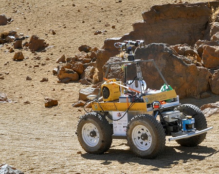
The PRoViScout team experimented with a rover called Idris on the Spanish island of Tenerife in September 2012. The test-run demonstrated that the vehicle’s on-board camera system could scan the terrain for hazards, pinpoint objects to study, decide which pictures to take and which to transmit back to Earth, as well as which trajectory to follow – all without receiving any instructions.
“We have assembled a complete new system in which the rover can decide where to go,” comments Paar.
Before taking a certain route, the PRoViScout rover would be able to consider the scientific value of a target, weigh the safety risks and factor in the depletion of its limited energy resources.
“One of the big challenges for a rover is simply not to get stuck,” adds Paar.
According to NASA, this is precisely what happened on 6th May 2009 to the rover Spirit, one of four vehicles that has explored Mars. More than five years into its mission, the 1.6-metre-long vehicle became trapped in soft sand and could not be freed. This sort of incident could become more likely as rovers in upcoming missions will have more range than current vehicles.
The difficulty in sending driving instructions from Earth to a rover on Mars stems from a simple matter of space and time. The average distance between the two planets is 228 million km, meaning that it takes about 10 minutes for radio signals from mission controllers on Earth to reach the red planet. If a rover is approaching either a hazard or something interesting to study, there may not be time for controllers on Earth to manoeuvre the rover away from danger or steer it towards an important scientific target.
Mars rovers carry a wide range of instruments. For example, various types of cameras can observe the landscape (including in 3D), zoom in on distant targets and examine the surface with close-up lenses and microscopes. Robotic arms have chemical sensors that analyse samples they collect. All these observations would be conducted more efficiently if a rover could choose its own path by using a system such as that developed by the PRoViScout team.
According to Paar, PRoViScout project’s navigation system is expected to be available for use for future missions such as Mars Sample Return in the 2020s, in which the European Space Agency (ESA) and the United States’ National Aeronautics and Space Administration (NASA) would send a vehicle to collect rock and dust samples on Mars and return them to Earth for study.
“In the future, rovers on Mars might travel a lot farther than they do today – up to tens of kilometres per day,” says Paar. “It is important they are able to decide on their own where to go and the system developed by the PRoViScout team is expected to support them in that task,” he concludes.