
A roadmap to help Africa’s cities adapt to climate change
Related topics
Environment & climate action Innovation International cooperation Societal Challenges Denmark Germany Italy United Kingdom Environment Norway Cameroon Ethiopia South Africa Burkina Faso Senegal Tanzania, United Republic Ofdate: 20/04/2015
Project: CLimate change and Urban Vulnerability i...
acronym: CLUVA
See also: CORDIS
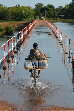
The risks from climate change – rising sea water levels, temperature increase and changing rainfall patterns – are challenging urban planners everywhere. But Africa’s cities are particularly vulnerable.
They mostly lack the skills and resources to reduce these risks, especially for the urban poor living in informal settlements typically located in or around many cities. Migration from rural areas and high fertility rates add to the challenges.
In response, the EU-funded CLUVA project developed approaches to help Africa’s communities adapt to climate change and reduce the risks posed by natural disasters.
These include techniques to create detailed climate change projections for Africa, new methods to assess susceptibility to flooding and desertification, software to help planners assess risks, and guidelines on steps cities could take to protect vulnerable infrastructure, housing and people.
CLUVA selected five sample cities as case studies to demonstrate the approach: Addis Ababa in Ethiopia, Dar es Salaam in Tanzania, Douala in Cameroun, Ouagadougou in Burkina Faso and St. Louis in Senegal.
The selection of such diverse locations – with variations in climate and geography – means other cities can easily adapt CLUVA’s approach to their specific situations, says project coordinator Paolo Gasparini of the Centre for the Analysis and Monitoring of Environmental Risk (AMRA), based in Italy.
“Among the key hazards, flooding appears to be the most devastating, as it is shared by all of the sample cities,” says Gasparini. “Other hazards include erosion, heat waves, drought and environmental degradation, such as desertification.”
Mapping climate change to Africa
CLUVA based its research on the Intergovernmental Panel on Climate Change’s projections of future emissions into the atmosphere of greenhouse gases, aerosols, and other pollutants.
The team developed techniques to downscale these global estimates to the regions in which the five cities are located. This resulted in the first local climate change maps for the continent.
The researchers used the data to simulate the effects climate change might have on local weather and to estimate the potential for extreme weather events.
“The project developed the first high-resolution climate change projections for Africa – providing scenarios up to 2050 of such factors as variations in temperature and precipitation for some of the most vulnerable regions,” says Gasparini.
These “high-resolution” climate change projections are available online free-of-charge.
In parallel, the project developed a new approach for assessing an urban area’s susceptibility to flooding and desertification, and an online analysis tool to help cities evaluate how to reduce risks with available resources.
Another software tool developed by CLUVA generates maps showing the number of buildings and people exposed to flood risk. The software identifies less-risky sites in or around a city that are suitable for future development.
CLUVA also demonstrated techniques for generating maps of areas exposed to high levels of risk – a city’s ‘hot-spots’. The maps aim to help local planners quickly identify areas where preventative actions need to be taken.
CLUVA’s researchers identified such actions, and others, in their guidelines for city authorities, which include advice on:
- engineering design and management of storm water systems;
- methods to analyse the reliability of roadways;
- procedures for emergency response;
- low-cost measures to strengthen houses in low-income settlements – for example, a layer of stones placed around the foundation of an adobe structure would help prevent flowing water from eroding its base;
- techniques to help low-income residents cope with and recover from the impacts of a natural disaster;
- strategies to get climate change policies adopted by city authorities.
CLUVA’s legacy – research and training
CLUVA’s achievements include roadmaps for further climate change research, and for training the next generation of African scientists, says Gasparini.
European and African researchers involved in the project teamed up to do the studies and involved African students completing PhD and post-doctoral training. The African partners included universities in all five case study cities.
Four training sessions held early on in the project supported this work. The researchers also developed six teaching modules for a Master’s course in climate change.
“The cooperation between African and European partners and the outcomes of the project have significantly advanced the research capacity in Africa with the potential for long lasting effects,” Gasparini adds.
CLUVA’s legacy even extends beyond Africa. A project funded by an arm of the World Bank has adapted the project’s guidelines to protect drinking water and sewage systems from disasters for use by cities in Ecuador.
The project’s tools could also be used in Europe. Civil protection authorities in Napoli, Italy, have adapted the project’s software to evaluate risks to the city from natural disasters such as earthquakes, volcanic activity, floods and landslides.
“In doing so, they have improved the software and shown that it can be adapted to local circumstances,” says Gasparini.
Below an example of CLUVA’s climate change projections indicating seasonal changes of temperature and precipitation for the time period 2021-2050 compared to 1971-2000.
@ AMRA S.c.a.r.l.