
An eye on Earth-shattering events
Related topics
Environment & climate action Innovation Space Germany Hungary Italy Netherlands Poland Spain Switzerlanddate: 09/10/2014
Project: Ground Deformations Risk Scenarios: an A...
acronym: DORIS
See also: CORDIS
Contact: Contact
We tend to take the ground we stand on as stable and immovable. But for the many thousands of Europeans living in mountainous regions, for example, there is a very different reality. Landslides and ground subsidence are serious problems across Europe and their costs are largely underestimated, according to Fausto Guzzetti of Italy’s National Research Council, which coordinated DORIS.
“In DORIS, we have observed entire mountain landscapes slowly moving over time – these regions are not as static as we thought.”
The project has developed systems for detecting, mapping, monitoring and forecasting ground deformations and movements caused by natural and human-induced phenomena. Examples include landslides, riverbank erosion and melting permafrost; and the human contribution can arise from activities such as mining, large construction works or water extraction for irrigation.
View from space
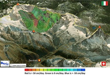
DORIS used the new mapping technologies offered by the Copernicus system of Earth observation satellites operated by the European Space Agency. These offer synthetic aperture radar (SAR) mapping, which involves taking images at different points in the satellite’s orbit and then combining them to detect sub-centimetre-scale height differences on the Earth’s surface. Using SAR, DORIS has proved it can record Earth movements and deformation over time.
“The ability to construct long time series, and the high spatial resolution provided by modern SAR sensors has meant that we could observe changes in urban and suburban areas with unprecedented accuracy,” says Guzzetti.
This is a significant result and “tipping point” for the services that the project’s small to medium-sized enterprise (SME) partners can now offer their customers now that the project has ended, he adds.
Indeed, the consortium brought together a diverse range of partners, researchers, SMEs, SAR data specialists, geologists and civil protection organisations who processed over 2000 SAR images from 13 areas in Europe, representing a wide range of environments and types of ground deformation.
They produced accurate deformation and rate-of-deformation maps revealing:
- slow-moving rock slides and ground subsidence owing to over-exploitation of aquifers in Italy and Spain;
- fast-moving rock glaciers and changes due to melting permafrost in Switzerland;
- human-induced subsidence caused by mining activities in Spain and Poland.
And the diversity of cases investigated showed that DORIS’s technology can be applied across Europe, according to the team.
Demand for DORIS
Landslides are natural events that shape landscapes. However, they come with a huge cost, both social and economic. In Italy alone, landslides have caused over 5000 deaths and displaced more than 150 000 people during the last 50 years, at an estimated economic cost of €2 billion annually.
In the UK, land subsidence has cost €3.6 billion during the last decade – making it the most damaging geohazard in the country. Insurance claims for subsidence in France and Germany run into hundreds of millions of euros annually, and they are rising.
Thanks to the project, civil protection authorities and landslide investigators have access to information that was simply not available previously, explains Guzzetti. The technology to come out of the project is state-of-the-art and there is growing demand for it in diverse fields, he says.
“Primary users are civil protection and planning authorities operating at a variety of scales, from urban to regional. But others are getting involved, such as mining companies, builders and developers, and utility and transport companies, and of course insurance companies.
“Our evaluation of potential markets, driven by our SME partners, makes us confident that DORIS’s technologies will have a long-term and sustainable impact across Europe,” concludes Guzzetti.