
Improved predictions to protect Europe’s coastlines
Related topics
Environment & climate action Innovation Belgium Bulgaria France Italy Netherlands Poland Portugal Spain United Kingdom Climate action Environmentdate: 26/09/2014
Project: Morphological impacts and coastal risks ...
acronym: MICORE
See also: CORDIS
Contact: Contact
In coastal areas in particular, the combination of rising sea levels, high population densities and the potential for higher intensity storms in the future means that the number of people at risk is likely to increase significantly. Given the current financial situation in Europe, it is not possible to invest in expensive disaster reduction infrastructure on national scales.
In response to these constraints, the European Union (EU)-funded MICORE (Morphological Impacts and COastal Risks induced by Extreme storm events) project started in June 2008. Involving 16 governmental, commercial and research institutions across the nine participating countries, each one with its case study site, the team’s main objective was to develop a prototype Early Warning System (EWS) for predicting coastal storm risk. The early stages of the project involved analysing historical storm events at the sites of interest, as well as collecting field measurements of storm impacts that occurred throughout the project.
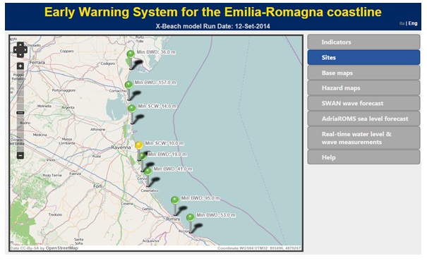
This information was then used to calibrate and further expand the numerical models, allowing them to more accurately simulate the hazards due to erosion of the coast or of defensive structures. The EWS is available online based on open source numerical models (X-Beach) and it works in real-time, providing information on general wave and tide conditions as well as more detailed morphological information for specific sites of interest within the study area. Using the software requires expert knowledge but the tools are available to anyone for consultation.
“One interesting thing we found is that there is no evidence of any increasing storm frequency,” says Professor Paolo Ciavola, coordinator of the MICORE project. “Obviously that does not mean that the risk is not going to increase because even if the storms remain the same we are increasing the pressure on the coastal zone with more people living there,” explains Ciavola.
With sites spanning from Gibraltar in the Mediterranean Sea to the Black Sea, and from the Baltic Sea to the North Sea, the chosen sites were representative of European coastlines with different exposures and coastal uses.
“We believe the approach we have developed is exportable. For example, in Italy we initially tested it on one beach but we are now applying it to the 130km coastline of the Emilia-Romagna region. We have been cooperating with the United States Geological Survey and they are applying a similar approach in California. We also have future potential applications in Bangladesh. So the format is widely applicable,” adds Ciavola.
The project was advertised at a local and national level, with newspaper and television interviews as well as open days to involve local communities and raise awareness. All of these developments will ultimately lead to the gradual improvement of disaster forecasting and response methods, which in turn will increase public safety. As technological advances in related areas such as satellite observation allow the creation of more accurate maps,
Projects such as MICORE contribute to the improvement of Disaster Reduction Strategies, while also establishing links between scientists, policy makers and emergency response managers.
Press Release in all EU languages available here