
Maps of Europe
date: 15/07/2016
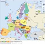
The most used map of the EU is designed to be viewed roughly in size 15*15 cm – within an A4 print page or a PC screen.
The multilingual version is the standard one. That means that the names of the countries are written in their own language. That makes it easier to use the maps across borders and it shows the real European spirit. It is a minor educational challenge to figure out what a word like' Deutschland" means, if you are from a country not used to see it.
However, we now also have these maps in uni-lingual versions in each of the 24 official EU languages. There are also maps showing the euro-area and the history of all EU enlargements. Furthermore, we have files for maps of Europe with more details.
If you want to tailor our maps for your own specific use, for example changing the colours, we can provide the original image files with a manual that gives all conditions and technical help.
You can download the most popular map images directly from the Commission audio-visual library. Get them here and here
Other formats and files of maps of Europe are available for reproduction, upon demand. Contact: Comm-Info-Publications@ec.europa.eu
Webmasters working in EU institutions might be interested in the corporate web-map project, which offers an easy way to get correct maps on your website. Read about it here (requires login by a Commission official)
A printed map measuring 43 x 47 cm can be found in the "Travelling in Europe 2016-17" leaflet.