This article forms part of Eurostat’s methodology manual on territorial typologies.

Coastal areas are local administrative units (LAUs) that are bordering or close to a coastline. A coastline is defined as the line where land and water surfaces meet (border each other). Due to the existence of several measures (eg, the mean or median tides, high- or low-tides), the European Commission has adopted the harmonised use of the mean high tide (EC, 1999) in order to delineate EU coastlines.
Classes for the typology and their conditions
Coastal areas are a classification based on the following two categories:
- coastal areas: LAUs that border the coastline or LAUs that have at least 50 % of their surface area within a distance of 10 km from the coastline;
- non-coastal areas: LAUs that are not ‘coastal areas’; in other words, LAUs that do not border the coastline and have less than 50 % of their surface area within a distance of 10 km from the coastline.
The main building blocks for the coastal areas classification are data for local administrative units (such as municipalities). Coastal areas and non-coastal areas are classified according to the distance of each LAU to the coastline. The coastal areas typology is therefore atypical, insofar as it is based exclusively on topographical information, while other local typologies are constructed from statistics on population grids. If an LAU borders the coastline, it is by default coastal. If an LAU does not border the coastline but it has at least 50 % of its surface area within a distance of 10 km from the coastline, then it is also considered to be a coastal area. All remaining LAUs are considered as non-coastal areas. An example showing how the methodology is applied to the coastline of Belgium is shown in Map 1.
The coastal areas typology is exhaustive, insofar as coastal and non-coastal areas together cover the whole of a territory. Note that among the European Union (EU) Member States, Czechia, Hungary, Luxembourg, Austria and Slovakia are landlocked and therefore do not have any coastal areas; the same is true for the European Free Trade Association (EFTA) countries of Liechtenstein and Switzerland and for the candidate countries of the former Yugoslav Republic of Macedonia and Serbia.
Further adjustments
There are a small number of special cases where the definition of a ‘coastline’ is treated on a case-by-case basis; for example, how to treat fjords, river estuaries or small islands. These country-specific exceptions to the underlying methodology have been agreed with the national statistical authorities of the EU Member States or EFTA countries in question.
Sea or inland water? An example for the Netherlands
In the Netherlands, the IJsselmeer is a closed area of inland water separated from the sea by a man-made dam (dyke). When applied rigorously the line marking the buffer zone that is 10 km from the coastline should be drawn with reference to the dam (as shown and as applied in the classification). An alternative would be to draw the buffer with reference to the inland coastline around the IJsselmeer (not shown), the result would be quite different.
Fjords? An example for Norway
The municipality of Årdal (shown by the green line) is located at the end of Sognefjord, which is the deepest and longest fjord in Norway. It is a major tourist destination due to the spectacular scenery along this stretch of water. Årdal, together with other LAUs along the fjord, is considered as a coastal area (despite being approximately 200 km from the open sea).
Estuary? An example for the United Kingdom
In the United Kingdom, the estuary of the river Humber begins at Trent Falls which marks the confluence of the river Ouse and the river Trent. All three of these rivers are tidal and hence there are a relatively large number of LAUs that are considered to be coastal areas. An all-encompassing definition (as shown above, but not applied for the classification) would include all of the LAUs along the estuary up to and including the city of Hamburg as coastal areas.
Small islands? An example for Germany
In Germany, the estuary of the Elbe river provides an alternative example for an estuary. Contrary to the all-encompassing definition applied for the river Humber in the United Kingdom, a stricter definition was applied for the river Elbe, whereby a majority of the estuary is excluded from being classified as a coastal area although the city of Hamburg (shown by the green line) is considered as a coastal area. This may be attributed to Hamburg’s strong maritime influence (with easy access its ports), while some small islands off the German coast (Neuwerk, Nigehörn and Scharhörn) are administratively part of the city of Hamburg and, as such, the LAU of Hamburg borders the coastline.
Links to other spatial concepts/typologies
Coastal areas are a subgroup of coastal regions (see Chapter 7).
Within this context, it also worthwhile noting that the EU’s outermost regions — principally islands and archipelagos in the Caribbean, the Western Atlantic and Indian Ocean — are largely composed of coastal areas (except Guyane). Furthermore, to address an ad-hoc request from the Directorate-General for Maritime Affairs and Fisheries, Eurostat identified 255 coastal cities/maritime ports and produced some basic statistics on these; for more information, see here.
Results
Using the above definition, and on the basis of data for reference year 2016, there were 6 838 LAUs in the EU-28 that were bordering the sea and a further 6 985 LAUs that were not bordering the sea but had at least 50 % of their surface area within 10 km of the sea. As such, more than 12 % of all LAUs in the EU-28 were coastal areas, a share that ranged — among those EU Member States with a coastline — from 0.7 % in Romania to 100.0 % in Denmark and in Malta (see Figure 1).
A correspondence table between coastal/non-coastal areas and LAUs is available on Eurostat’s classification server, RAMON.
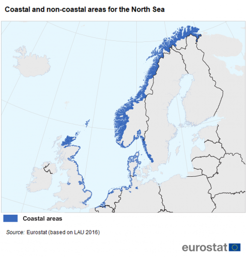
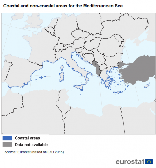
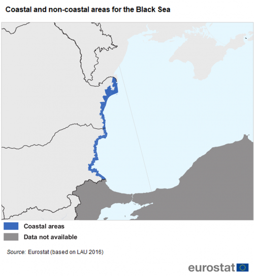
Maps 3-8 provide an overview of the final classification of coastal and non-coastal areas for the six sea basins that border the EU: the Baltic Sea, the North Sea, the North-East Atlantic Ocean, the Mediterranean Sea, the Black Sea and the EU’s outermost regions.
Changes to the typology over time
The coastal areas classification should be updated to reflect any changes in LAU boundaries. The list of LAUs is updated on an annual basis:
- information relating to any changes to the boundaries or structure of LAUs should be communicated by EU Member States to the European Commission (Eurostat) within the first six months of each calendar year, with reference to 31 December of the previous year;
- Eurostat publishes a revised list of LAUs before the end of the same year.
Once geodata for the new LAU breakdowns become available in late autumn of each year, Eurostat updates the coastal area typology in the LAU list.
Further information
Glossary entry:
Detailed methodology:
Dedicated section:
Coastal, island and outermost regions
Published indicators
Tourism statistics for coastal and non-coastal areas have been collected by Eurostat since the 2012 reference year. The legal basis for the collection of this data is Regulation (EU) No 692/2011.
Database:
Eurostat’s website presents statistics for coastal and non-coastal areas. They are available here.
Examples

(% share of total number of tourist accommodation establishments)
Source: Eurostat (tour_cap_natc)
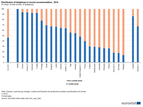
(% share of total number of bedplaces)
Source: Eurostat (tour_cap_natc)
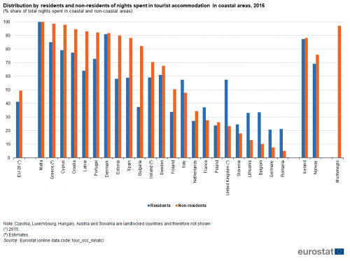
(% share of total nights spent in coastal and non-coastal areas)
Source: Eurostat (tour_occ_ninatc)
Explore further
Thematic section
Methodology
Legislation
- Regulation (EU) No 692/2011 - European statistics on tourism


