Territorial typologies manual - coastal regions
This article forms part of Eurostat’s methodology manual on territorial typologies.

Full article
Classes for the typology and their conditions
Details of the typology
The basic coastal typology is a classification based on the following two categories:
- coastal regions;
- non-coastal regions (those regions that are not defined as coastal regions).
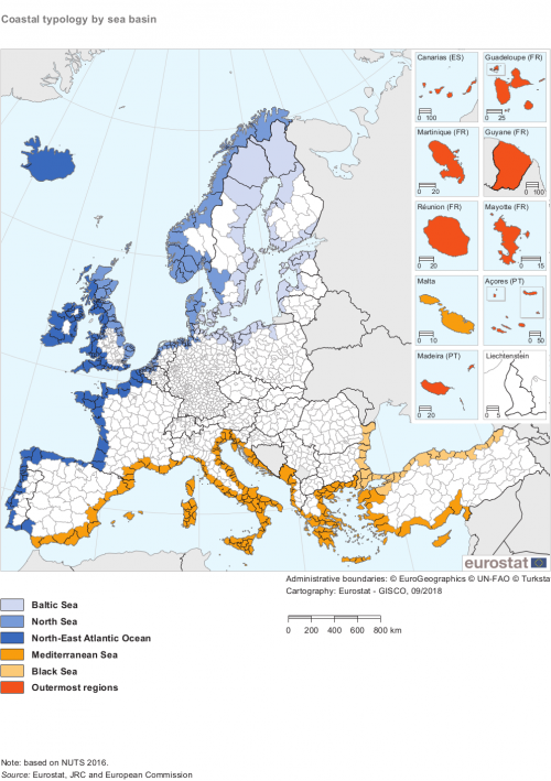
Coastal regions can also be classified according to the sea basin in which they are located. A sea basin is a geographical entity composed of a sea/ocean and the coastal region (land basin) that borders the sea/ocean/coastline. At an aggregated level of detail the following sea basins may be identified for EU regions:
- Baltic Sea;
- North Sea;
- North-East Atlantic Ocean;
- Mediterranean Sea;
- Black Sea;
- outermost regions.
Methodology for the typology
Coastal regions are NUTS level 3 regions in the EU, defined according to one of the following three criteria:
- any NUTS level 3 region with a sea border (coastline);
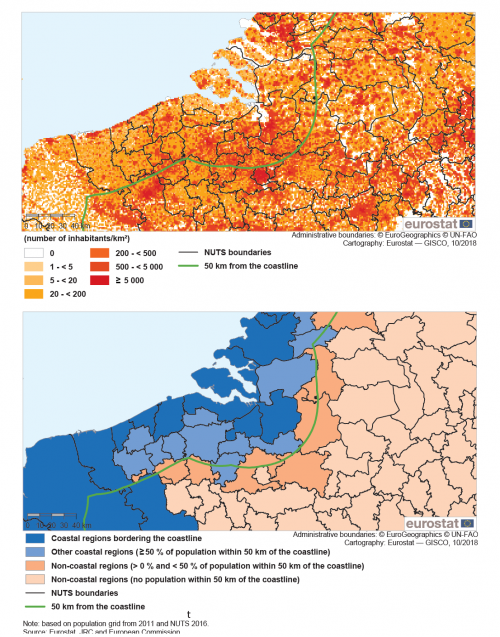
- any NUTS level 3 region that has more than half of its population within 50 km of the coastline, based on population data for 1 km² grid cells;
- the NUTS level 3 region for Hamburg in Germany.
Case 1: regions with a sea border (coastline)
The first of these criteria is self-explanatory. There are 23 EU Member States that have a coastline and therefore also have coastal regions, while Czechia, Luxembourg, Hungary, Austria and Slovakia are landlocked countries and are therefore exclusively composed of non-coastal regions.
Case 2: regions with more than 50 % of their population within 50 km of the coastline
This criterion requires two sources of information:
- the number of inhabitants living in 1 km² grid cells that are within 50 km of the coastline (A) — more information on population grid statistics is provided in the introductory chapter;
- the number of inhabitants living in each NUTS level 3 region (B);
Use this information to compute the share of the total population in each NUTS level 3 region that lives within 50 km of the coastline ((A/B)*100). Classify all regions that have shares that are greater than 50 % as coastal regions.
Case 3: the region is Hamburg
Although Hamburg (NUTS level 3 code DE600) is a significant distance from the sea, it is also considered as a coastal region given its strong maritime influence (with easy access for large ships down the river Elbe to its ports) and the fact that some small islands off the German coast — Neuwerk, Nigehörn and Scharhörn — are administratively part of the city of Hamburg and so it may said to border directly onto the coastline.
Links to other spatial concepts/typologies
There is a close link between the typologies for coastal regions and coastal areas (see Chapter 4). The latter are considered to be a subgroup of coastal regions: as such, any NUTS level 3 region that is classified as a non-coastal region cannot (by definition) have any coastal areas.
Results
Based on the above definitions, there are 491 NUTS 2016 level 3 coastal regions in the EU-28. Of these, 396 regions have a coastline, 95 regions have no coastline but more than 50 % of their population living within 50 km of the sea. For all EU Member States, Iceland, Norway, Montenegro, Albania and Turkey, a list of coastal regions is available here.
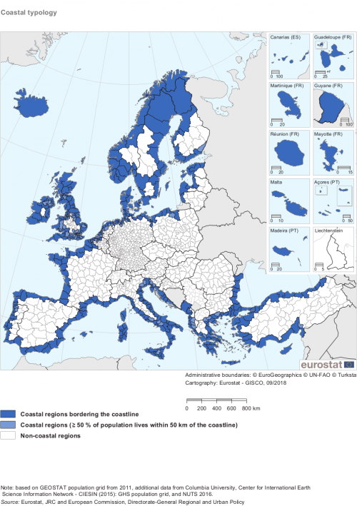
Map 1 provides an overview of the final classification for the coastal typology (with a division between coastal and non-coastal regions, with the former being split between those regions that have a coastline and those which have more than 50 % of their population within 50 km of the sea).
As noted above, each coastal region can be assigned to a sea basin. Map 2 provides an overview of the main sea basins within the EU, EFTA and candidate countries.
Changes to the typology over time
The coastal typology was developed by Eurostat in consultation with other services of the European Commission.
Changes over time that impact on the classification
The coastal regions classification should be updated to reflect any changes to the underlying sources of information that are used in its compilation. As such, the classification may be updated to reflect: changes to population distributions for 1 km² grid cells, or changes in the NUTS classification. The frequency of such updates varies according to the source of information.
The NUTS Regulation specifies that the classification of regions should remain stable for a period of at least three years; the most recent updates were for NUTS 2010, NUTS 2013 and NUTS 2016. After each revision of the NUTS classification, population grid statistics should be re-assessed in order to (re-)compute the share of each NUTS level 3 region living within 50 km of the sea. Changes to the coastal regions classification resulting from a revision of population distributions for 1 km² grid cells are less common and these may be expected every 10 years. The next major update of the population grid is foreseen to take place for the 2021 reference year.
Future developments
The next update of the NUTS classification is foreseen to take place in 2019.
At the time of writing, a 2021 population and housing census implementing regulation is in the process of being adopted by the European Commission. It includes an article for 1 km² population grid statistics. As well as information for annual counts of populations, it also foresees more detailed analyses: population by sex, population by age, number of employed persons, population by place of birth, population by usual place of residence one year prior to the census.
Eurostat are also discussing post-2021 census developments with national statistical authorities. It is hoped that the European statistical system (ESS) will agree to produce — from the mid-2020s onwards — annual counts of populations (based on usual place of residence) for a 1 km² grid, with data to be made available within 12 months of the reference period.
The European Commission’s Directorate-General for Maritime Affairs and Fisheries intends to incorporate a coastal/non-coastal layer into the European Atlas of the Seas showing the most important socioeconomic indicators that are related to the blue economy.
Further information
Glossary entry:
Detailed methodology:
Coastal, island and outermost-regions
Correspondence for NUTS regions:
Correspondence table for coastal, island and outermost regions
Published indicators
A variety of different statistical surveys collect data for NUTS level 3 regions and this information may be used to calculate data for coastal and non-coastal regions. This process involves aggregating the data for NUTS level 3 regions to compute a total or an average for all coastal (and non-coastal) regions within a territory (for example a Member State, or the EU as a whole).
Visualisation tools:
Eurostat publishes data for the coastal typology through Regions and cities illustrated.
Database:
Eurostat’s website provides information for a wide variety of indicators for the coastal typology. These statistics are available for the following statistical domains: demography, population projections, the labour market, crimes recorded by the police, economic accounts, business demography, intellectual property rights and transport. They are available here.
Example

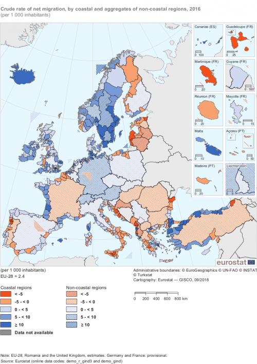
(per 1 000 inhabitants)
Source: Eurostat (demo_r_gind3) and (demo_gind)
Direct access to


