An EU-funded project in Malta will simplify data management and use real-time systems to make government information for town planning more accessible to external users. By consolidating spatial data and sharing it widely, this project contributes to Malta’s economic growth, sustainability and wellbeing.
- 03 February 2020
The development of a strategy to inform the use of spatial information for social wellbeing serves as the project’s foundation stone. In total, 40 government entities were involved in this collaborative process to ensuring that the data is gathered only once, but can be used by any citizen for years to come.
Malta is a geographically small country, yet it has undergone many years of urban development. Around 95 % of its 316 km2 surface area is urbanised. Unfortunately, Maltese government entities have not always had access to the same information for town planning, which has led to inefficient decision-making.
Using hi-tech mapping equipment, the SIntegraM project is providing policy makers, academics, citizens and the business community with a complete picture of the nation’s geography and infrastructure. The projects return on investment is estimated to be around 3.5 times its cost.
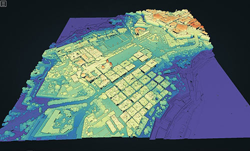
Rendering real-time 3D maps
Updated maps of Malta have been long overdue. There is a lack of alignment and much disparate information between decision-makers. ICT is deemed essential for Malta’s economic growth and the nation’s digital strategy sets out that government services need to be designed around people’s needs.
SIntegraM stands for Developing Spatial Data Integration for the Maltese Islands and will update Malta’s maps with an evidence-based approach that freely shares the information.
Drones and car-mounted cameras are used to map the islands’ topography and surrounding sea waters. Underwater objects are studied and experts measure the depth of water in Malta’s oceans, rivers and lakes. Urban planning is being analysed so that sewer networks and other underground features can be integrated into the data sets.
Once gathered, the data is processed by software capable of rendering real-time 3D maps. This approach is known as geographic information systems (GIS). The data and maps are being made available online via the project’s geoportal.
In case of emergency
These new maps will be invaluable in the case of a disaster like an earthquake or tsunami, where the data could be used to respond effectively to emergencies or to rebuild afterwards. All the information gathered is stored securely so it can be accessed in the event of a breakdown in communication networks.
New departments of Malta’s government are now using GIS that have never done so before. The project will end in 2020, but has long-term impact and value. For instance, it has created a specialised career stream in the Maltese Government based on spatial qualifications.
The net economic benefit has been estimated to be EUR 24 168 600 due to the large number of users that could benefit from the GIS. Policy makers and businesses now have the tools to plan and implement projects that fit the needs of the region and its communities.
Total investment and EU funding
Total investment for the project “SIntegraM - Developing Spatial Data Integration for the Maltese Islands” is EUR 7 000 000, with the EU’s European Regional Development Fund contributing EUR 4 000 000 through the “Fostering a competitive and sustainable economy to meet our challenges” Operational Programme for the 2014-2020 programming period. The investment falls under the priority “sustainable urban development”.