
First operational activation of the Aerial Component of the Copernicus Emergency Management Service (CEMS)
date: 12/12/2022
During the night of 25 November 2022 and the early morning of the 26th, a deep cyclone brought heavy rains to central and southern Italy, particularly over the Campania region. The heavy rains triggered landslides on the slopes above the hamlet of Casamicciola, in the island of Ischia. At least ten houses were destroyed and several cars along the roads were swept away by the mudflow into the sea.
CEMS Rapid Mapping was immediately activated by the Italian Civil Protection to support rescue operations and evaluate the damage. A first delineation product was delivered using Pleiades satellite imagery acquired on 27 November 2022.
Contextually, the CEMS activated its Aerial Component, manned (airplanes) module, for the first time, on the evening of 26 November; the actual flight of the aircraft was executed the next morning. The products were ready to be downloaded by the morning of 29 November; they consisted of an ortho-mosaic at 15cm/pixel and Lidar data 8-10 points/m2, covering the entire Ischia Island territory.
The imagery, in addition to the digital surface model derived from the Lidar data, was used by the Rapid Mapping service provider as a complement to the satellite data, to deliver a Grading Product (i.e. map providing information about the damage grade, its spatial distribution and extent).
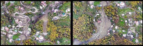
Moreover, the unmanned module (drones) of the Aerial Component was promptly activated but was unable to fly over the area in the aftermath of the landslide, as emergency response helicopters were involved in Search and Rescue operations. Drone flights were completed in the afternoon of 1 December, for a subset of the area of interest covering the town of Casamicciola, with a spatial resolution of 5 cm.
Thanks to the amount of data generated by the CEMS Aerial Component, a complementary Risk and Recovery Mapping activation is being considered by the Civil Protection, with a number of products that could be developed and delivered in a relatively short timeframe, including:
- Landslide risk assessment on the entire island of Ischia
- Exposure of property and population in the areas subject to landslide risk
- Estimation of potential economic consequences
- Estimates of the volume of the landslides that affected the area during this event
- Detailed damage assessment using ground truth information from Civil Protection units
- Updated reference mapping
- Survey of ground movement using Sentinel-1 on the island between 2012 and 2022 every two years
- Coastal erosion assessment
Links: https://emergency.copernicus.eu/EMSR643

Figure: Details from the ortho-mosaic produced by the drone flight of the CEMS Aerial Component over the landslide area of Casamicciola, Ischia, Italy