
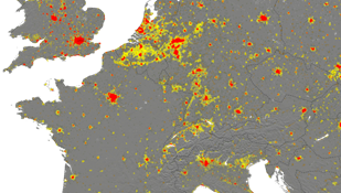
A map layer showing urban settlements worldwide
date: 05/10/2022
Information about the exposure of populations and human settlements is fundamental to managing crises and assessing disaster risk and the Global Human Settlement Layer (GHSL) helps find answers.
This project delivers global spatial information on the human presence on the planet over time by combining Earth observation data with census data and other socio-economic variables. The result is a suite of datasets mapping built-up surfaces, population density and settlement typology maps taking the shape of global layers.
These layers/data, which are integrated into CEMS components like Rapid Mapping, EFFIS, GloFAS, EFAS, EDO and GDO, among others. Applications include population estimation for the United Nations Convention to Combat Desertification (UNCCD) toolbox and burnable area information for the Global Wildfire Information System.
 |
||
|
||