
New tool to provide a harmonised fire risk assessment across the Pan-European region

date: 05/10/2022
To mitigate the damaging effects of wildfires, harmonised procedures for wildfire risk assessment are needed at the Pan-European scale, enhancing planning and coordination of prevention, preparedness, and cross-border firefighting actions.
A report stemming from the collaboration between the European Commission and fire specialists from 43 countries was published earlier, this summer. The report focuses on wildfire risk assessment and provides harmonised data in the Pan-European region. This is of special interest in fire-prone regions, where coherent strategies are needed to prevent wildfire damages.
As fires rage across the EU and the globe, there is a widespread consensus that firefighting, only, is not the answer when it comes to mitigating the damage caused by wildfires. To face the forthcoming wildfire danger situations under climate change, a focus on wildfire prevention with a specific attention on proper planning of the landscape is required, to avoid the profusion and continuity of fuel materials on the ground, and to protect human lives and assets in fire-prone areas. For this purpose, the assessment of wildfire risk is essential.
The first Pan-European wildfire risk assessment (WRA) conciliates previous approaches used by different countries, making a comparable assessment of wildfire risk across countries and regions in Europe possible. This harmonised method will support the EU and its Member States protect lives and their natural environment.
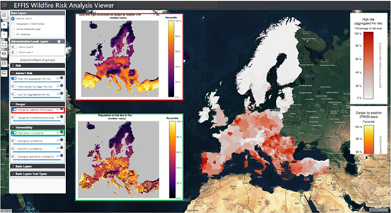 |
| A preliminary version of the pan-European Wildfire risk map viewer. Values displayed in the map correspond to the high-risk class at administrative levels, based on GADM. As an example of some of the layers included on the viewer, the inside boxes display the Danger by Weather (red frame) and the aggregated index of population vulnerability (green frame). |