Archive:Agricultural census in Spain
This article is part of a series of country-specific essays on the results of the European Union (EU) Farm structure survey (FSS) 2010. The FSS collects information on the structural characteristics of the agricultural holdings (land use, livestock and labour force) and is carried out by all European Union Member States every 10 years as an Agricultural census, with two or three additional, intermediate sample surveys carried out in-between. In Spain, the present analysis of the farm structure includes a comparison with the previous (2000) Agricultural census. Although the reference years of the Agricultural census in Spain were 1999 and 2009 respectively, the common designation is Agricultural census 2000 and 2010.

Source: Eurostat (ef_kvaareg) (ef_ov_kvaa) (demo_pjan) and FSS 2000 and 2010

Source: Eurostat (ef_kvaareg) (ef_ov_kvaa) and FSS 2000 and 2010

Source: Eurostat (ef_kvaareg) (ef_ov_kvaa)

Source: Eurostat (ef_lu_ovcropaa) (ef_oluaareg)
Source: Eurostat (ef_lu_ovcropaa) (ef_oluaareg)

Source: Eurostat (ef_mptenure)

Source: Source: Eurostat (ef_pmhouscatlaa)
Main statistical findings
Key indicators
In 2010 there were 989 800 agricultural holdings in Spain. After the year 2000 the number of agricultural holdings decreased by 23.1 %, following the general pattern of the European agriculture.
In 2010 the utilised agricultural area (UAA) in Spain represented 47 % of the whole territory; a decrease of 9.2 % was reported as compared to the previous census. In terms of the average size of the agricultural holdings, positive developments were observed as the size increased from 20 ha in 2000 to 24 ha in 2010. When looking at the animal livestock expressed in livestock units (LSU), it can be observed that in 2010 14.8 million LSU were recorded in Spain, which represented only 1 % decrease when compared to 2000.
Between 2000 and 2010, the number of persons working in agriculture dropped by 8.7%, from 2.4 million to 2.2 million. However, the population working in agriculture still represented 9.8 % of the economically active population of Spain in 2010.[1]
According to the FSS 2010 data, there were on average 0.52 hectares of UAA per inhabitant in Spain. This figure indicates a decrease (-21 %) from the one recorded during the Agricultural census in 2000, when the UAA per inhabitant was 0.66 hectares.
Regional key indicators
When comparing the 2000 data with the 2010 data, at regional level the decline in the structure of Spanish farms appears to be generalised. Accordingly, every region of Spain shows negative values in terms of both the number of holdings and the utilised agriculture area (UAA). Nevertheless, between 2000 and 2010 most of the regions recorded an increase in the average UAA per holding.
In particular, ‘Comunidad de Madrid’ was the territory with the largest decrease in the number of holdings (-33.5%), while ‘Cataluña’ was the one showing the smallest drop (-9.5%). Also in terms of the agricultural area, ‘Cataluña’ was the region displaying the smallest fall (0.5%), while ‘Pais Vasco’ was the one recording the highest decrease (-25.4%). As regards the LSU data, five regions recorded a positive trend: ‘Aragón’ (+18.1 %), ‘Comunidad Foral de Navarra’ (+11.7 %), ‘Castillia-La Manchia’ (+5.2%),‘Region de Murcia’ (+2.9 %) and ‘Andalucia’ (+1 %).
Agricultural holdings
Between 2000 and 2010, in terms of the size of agricultural holdings, there was a tendency for the small holdings to disappear in favour of the bigger ones. According to the FSS 2010 data, the number of farms with less than 2 ha of UAA dropped from 396.570 to 270.280 (-31.8 %), while the number of holdings with 100 ha or more increased from 48 540 to 51 190 (+5.5%).
Currently, more than half of the agricultural holdings in Spain have less than 5 ha of UAA. On the contrary, the farms with 100 ha or more of UAA represent 55% of the total UAA and only 5% of all the agricultural holdings.
For 2010 data at NUTS 2 level click here
For 2000 data at NUTS 2 level click here
Economic size of the farm
In 2010, the economic size of all the Spanish agricultural holdings was 34 173 million Euro, a value calculated by adding all the standard output (SO) per hectare of crop and head of livestock of the farms. Compared to the 2007 FSS (33 363 million Euro), the 2010 data show an increase of 2.4%, which is mainly attributable to the big holdings with an average monetary value of over 100 000 Euro per year. In 2010, all these big agricultural holdings put together accounted for 63 % of the total standard output.
For NUTS 2 data click here
Agricultural holding by main type of farming
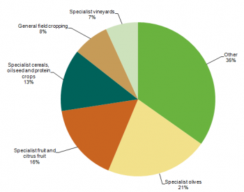
In terms of the main area of production, holdings specialised in olives production are the most common in Spain. According to the Agricultural census 2010, they represent about 21 % of the total number of holdings. The second most common type of production is fruits and citrus fruits, which is produced by 16 % of the total number of holdings. The holdings specialised in the production of cereals, oilseed and protein crops represent 13 % of the total number of holdings.
In terms of the economic size, the hierarchy of the holdings changes slightly. Indeed, when using the standard output (SO) for measuring the main type of farming, the holdings specialised in the production of fruits and citrus fruits have the biggest share (10 %). The second highest contributions came from holdings dedicated to the production of cereals, oilseed and protein crops (8 %), while the holdings producing olives are accounting for almost 7%. Farms specialised in general field cropping account for about 6 % of the total standard output, whereas those specialised in vineyards share 3 % of the country’s SO.
For 2010 data at NUTS 2 level click here
Land use
Utilised agricultural area (UAA) is the total area taken up by arable land, permanent grassland and meadow, permanent crops and kitchen gardens used by the holding, regardless of the type of tenure or of whether it is used as a part of common land.
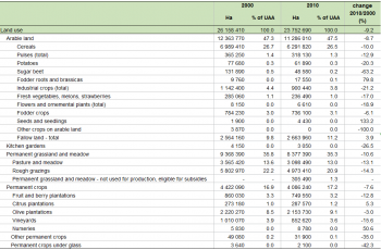
In Spain the UAA decreased by more than 2.4 million hectares after the year 2000 (9.2%), currently standing at 23.7 million hectares. According to the 2010 Agricultural census data, this general fall in the UAA did not change the nature of the land use in Spain, so that the shares of the area occupied by arable land, permanent grassland and meadow, permanent crops and kitchen gardens remained almost at the same level as in 2000. Accordingly, the arable land is still the most representative category of land in the total UAA, having a share of more that 47% in both reference years.
For 2010 data at NUTS 2 level click here
For 2000 data at NUTS 2 level click here
Arable land
In Spain, the land worked (ploughed or tilled) regularly, generally under a system of crop rotation, decreased by 8.7 % in 2010 as compared to 2000. This fall was the result of the reduction in the area of most of the agricultural crops, such as industrial crops (-21 %), potatoes (-20 %), pulses total (-13 %) and cereals (-10 %).
The total number of agricultural holdings with arable land also registered a decrease, from 663 530 in 2000 to 463 420 (-30 %) holdings in 2010. Overall, the number of farms with less than 10 ha arable land decreased by more than 40 % in 2010 as compared to 2000. The number of holdings with arable land increased only for the farms with more than 100 hectares; 51 190 of those farms were registered in 2010, 2 100 more than in 2000.
For 2010 data at NUTS 2 level click here
For 2000 data at NUTS 2 level click here
Permanent crops
In 2010 the area under permanent crops represented 17 % of the UAA, which was the same as the share that this area represented in total UAA in 2000. However, a decrease of 8% of the area under permanent crops was observed in 2010 as compared to 2000, as well as a decrease of -28% in the number of agricultural holdings. The most important permanent crops, olive plantations and vineyards, registered a noticeable reduction in the number of farms (-19.5 % and -43.1 % respectively).
For 2010 data at NUTS 2 level click here
For 2000 data at NUTS 2 level click here
Permanent grassland
Between 2000 and 2010, the area of permanent grassland decreased by 11 %. This was the result of the decrease of both the rough gazing area and the area dedicated to pasture and meadow.
Three different types of permanent grassland are identified in the Agricultural Census: the permanent pasture generally used for intensive grazing; the rough (extensive) grazing with a low density of livestock; and the permanent grassland used not for production but rather for keeping the land in good agricultural and environmental conditions (GAEC). In 2010, 37 % of the permanent grassland was intensive grazing, 59 % was rough grazing and only 4 % was used for keeping land in GAEC.
For 2010 data at NUTS 2 level click here
For 2000 data at NUTS 2 level click here
Livestock
Statistics on livestock use two different units of measurement: the number of heads (number of animals) and the livestock units (LSU). The latter makes the comparison between different types of livestock possible.
In Spain, according to the 2010 data, there were 0.32 LSU per inhabitant (in 2000 there were 0.38). Indeed, the population of livestock decreased by 1.1% LSU over the period 2000-2010. This small fall is the combined effect of the increase in LSU for certain species and the drop which characterised others. Poultry (10.6 %), equidea (8.7 %) and pigs (6.7 %) were the species which showed positive values when compared with the 2000 data. On the contrary, the figures for rabbits (-27.1 %), sheep (-20.8 %), goats (-13.3 %), and cattle (-7.1 %) all decreased.
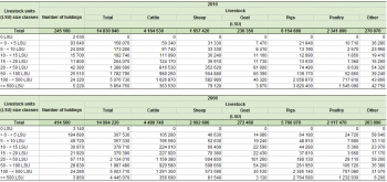
The number of agricultural holdings with livestock decreased by 40.9 % over the 2000-2010 period, from 414 500 to 245 160. Related figures decreased for all the Spanish regions; they halved for La Rioja (-55.2%), Comunidad Valenciana (-55.1%), Castillia y Leon (-51.2 %) and the islands of Canarias (-51 %). As regards the number of LSU, the largest decreases were recorded by the islands of Baleares and Principado de Asturias: -31.2 % for the former, -20.6 % for the latter.
Overall, the farms which suffered the largest decrease in terms of livestock unit were the ones with a small number of LSU. Indeed, the biggest decreases were observed on the farms with 5 to 9 LSU (-51.5 %). On the contrary, the ones with 500 LSU or more showed a large increase (+31.7 %).
For NUTS 2 data click here
Labour force
In 2010, 2.2 million persons were employed in the agricultural holdings, indicating a decrease of 7.1 % in comparison with the 2000 data when roughly 2.4 million persons were working in the agriculture sector. If the annual work unit (AWU) is used, this decrease duplicates reaching 15.5 %. Indeed, in absolute terms the labour force fall from 852 720 AWU of the 2000 to 720 860 AWU of the 2010.
When comparing the 2010 data with the 2000 data a decrease in the AWU directly employed in the agricultural sector is observed (-17.5 %). This decrease concerns both the direct labour force employed on a non-regular basis (-25.3 %) and the regular labour force (-15.5%). A slight increase was recorded for the labour force not directly employed by the agricultural holdings; figures increased by 0.6 % in 2010 as compared to 2000, moving from 32 790 AWU to 33 000 AWU.
For NUTS 2 data on holders' age and sex click here
For NUTS 2 data on type of labour force click here
Management practices
Type of tenure
In Spain, according to the 2010 data, roughly 14.5 million hectares of UAA (61%) belonged to the farmers who actually worked on that land. The highest amount of owned land was recorded in ‘Andalucía’ (3.1 million hectares) and the territories of ‘Castillia-La Mancha’ and ‘Castillia y Leon’, both recording roughly 2.6 million hectares of land farmed by the owners.
The shared-farming agricultural area, which is agricultural area utilised in partnership by the landlord and the sharecropper under a written or oral share-farming contract, or area utilised under other modes of tenure, was relatively small (1.7 million hectares). It characterised 92 540 holdings, 17.980 of which were located in Andalucía.
Irrigation
Between 2000 and 2010, the total irrigable area increased by 3.2 %, from 3 478 050 to 3 587 770 ha. On the contrary, the irrigated area – which does not include kitchen gardens and any area under glass – dropped in 2010 by 5.9 % as compared to 2000. However, when analysing data on irrigation, it should be kept in mind that the extent of the irrigated area varied over the years according to the weather conditions.
In terms of the type of crops, the harvest that had the largest share of irrigation water in Spain was cereals (excluding maize and rise). According to the 2010 data, cereals covered 630 350 ha of irrigated area, a share of 20.7 % of the total irrigated area of the country. With 480 430 ha of irrigated area, the olive plantation was the second most irrigated crop (15.8 %), followed by maize (grain and green): 313 830 ha and 10.3 % of the total irrigated area.
For 2010 data at NUTS 2 level click here
For 2000 data at NUTS 2 level click here
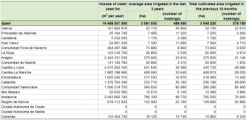
In terms of the volume of water, 16.658 millions of cubic metres of water were used to irrigate the UUA in Spain in 2010. The volume of water includes the water used for the kitchen gardens and area under glass. The estimated value takes into account several factors and was calculated for the first time with the 2010 FSS. Clearly, the amount of water used in agriculture strongly depends on the region and its peculiarities. Not surprisingly, the region of Cantabria in 2010 was used by the smallest volume of irrigation water (5 232 050 metre cubes), whereas Andalucia was the one which recorded the highest value (3.443 millions).
For NUTS 2 data click here
Animal housing
According to the 2010 data, there were 111 840 holdings raising 5 840 800 heads of cattle. Only, 24 800 among them (22.2%) proved to host cattle in stanchion tied stables with solid dung and manure for a total of 1 229 170 places. Moreover, 20 700 holdings were recorded as hosting cattle in stanchion tied stables with slurry, for a total amount of 644 960 places. In addition, 12 410 holdings hosted cattle in loose housing with solid dung and liquid manure (1 060 390 places), while 13 730 holdings (12.3 %) were characterized by cattle in loose housing with slurry (832 770 places).
Other gainful activities
According to the data of the Agricultural census 2010, there were 20 790 holdings with other gainful activities in Spain. Representing 2.1% of the total number of holdings, these farms recorded activities other than farm work, directly related to the holding and having an economic impact on the holding.
Information on other gainful activities was collected by eleven category types depending on their characteristics. The most common one was processing of farm products, which involved 5 120 holdings according to FSS 2010 data. When analysing data on other gainful activities it must be noted that holdings involved in more than one other gainful activity were counted more than once.
For NUTS 2 data click here
Organic farming
Organic agriculture is an ecological production management system that promotes and enhances biodiversity, biological cycles, and soil biological activity. It is based on the minimal use of off-farm inputs and on management practices that restore, maintain or enhance ecological harmony.
In Spain the number of agricultural holdings practicing organic farming grew after 2003, from 10 270 farms to 14 630 farms registered during the last Agricultural census. Accordingly, the UAA with organic farming grew, from 301 570 ha in 2003 to 342 950 ha in 2010.
For 2007 and 2010 data at NUTS 2 level click here
For 2000, 2003 and 2005 data at NUTS 2 level click here
Data sources and availability
Methodological notes Spain – Agricultural census 2010
The Agricultural Census 2010 was the third Agricultural census harmonised with the European legislation to be carried out in Spain. The editions of the census prior to the 2010 one were in 1989 and 1999. The Farm Structure Survey (FSS) was also held in 1993, 1995, 1997, 2003, 2005 and 2007; these intermediate surveys were sample surveys. The Spanish Statistical Institute (INE) in coordination with its regional agencies implemented the FSS 2010, which, as mentioned, was carried out as an Agricultural Census.
Survey on agricultural production methods (SAPM)
In 2010 a unique survey was carried out together with the Agricultural census: the Survey on agricultural productions methods (SAPM). This survey collected data at regional level needed to establish agri-environmental indicators as indicated in COM final 508/2006 and to evaluate the greening of the Common agricultural policy.
Data were collected according to specifications listed in Annex V of the above mentioned regulation, namely data on tillage methods, soil conservation, landscape features, animal grazing, animal housing, manure application, manure storage and treatment facilities and irrigation.
The Survey on Agricultural Production Methods (SAPM 2009) was carried out using stratified random sampling. Firstly, the series of holdings subject to exhaustive investigation was calculated. And secondly, the population was distributed into strata formed by cross-referencing Autonomous Communities, two-digit types of farming (TF2) and five size groups. The sample size was calculated by applying optimal allocation, meeting the accuracy requirements set down in Annex IV to Regulation (EC) No1166/2008. The sample was randomly obtained in each stratum. Lastly, the calibrated estimators of the variable totals and the sampling errors were calculated.
Reference period
For the information related to land and labour force (including OGA), the reference period is the agricultural year 2009, the agricultural campaign from 1 October 2008 to 30 September 2009.
For the information related to livestock, the reference date is 30 September 2009. To measure the rural development and for the section on landscape elements, the reference period is the three years prior to the survey, i.e., 1 January 2007 until 31 December 2009.
Threshold for agricultural holdings
With reference to size, different thresholds are applied in the EU Member States to define the population of holdings eligible for the FSS and the Agricultural census. In the case of Spain, agricultural holdings were considered eligible when falling within one of the following independent criteria:
- Agricultural holdings with at least 1 ha of utilised agricultural area (UAA).
- Agricultural holdings with at least 0.2 ha of UAA used for fresh vegetables, melons and strawberries (2.01.07), flowers and ornamental plants (outdoors or under low protective cover)(2.01.08.01) or irrigated fruit and berry plantations and citrus plantations (2.01.08.01) nurseries (8.01.02.13+8.01.02.14) or nurseries (2.04.05) or under glass crops (2.02.07.02+2.01.08.02+2.04.07).
- Agricultural holdings with at least 0.1 ha of UAA used for under-glass fresh vegetables, melons and strawberries (2.01.07.02).
- Agricultural holdings with at least 0.1 ha of UAA used for under-glass flowers and ornamental plants (2.01.08.02).
- Agricultural holdings with at least 0.5 ha of UAA used for tobacco (2.01.06.01).
- Agricultural holdings with at least 0.5 ha of UAA used for hops (2.01.06.02).
- Agricultural holdings with at least 0.5 ha of UAA used for cotton (2.01.06.03).
- Agricultural holdings with one or more livestock units (LSU) and a total standard output (TSO) equal to or above 0.75 of the economic size of holdings (ES).
Common land
Common land is the land that does not directly belong to any agricultural holding but on which common rights apply. It can consist of pasture, horticultural or other land. The treatment of the common land used by an agricultural holding might differ from country to country.
Common land area in Spain is only accounted once and usually represents permanent grassland used as pasture for cattle and land not forming part of the UAA, e.g. wooded area and other lands. In most cases, arable land and permanent crops are not part of common land.
In the case of common land used jointly by several holdings, since it is not possible to assign a specific section to each farmer, the common land is considered a separate holding and all the land (without the cattle grazing on it) is counted in that holding, as with any other. The relevant common or local authority (State, Autonomous community, neighbourhood community, parish, etc.) is listed as the owner of the holding. If, during the agricultural production year, the owner leases or freely assigns all or part of the land to a single holding, the transferred/leased part is allocated to the holding that individually works this land.
Geo-reference of the holding
To determine the location of each holding, each holding must be included in an area not exceeding that determined by a radius of five geographical minutes. To determine the location of each holding in one of these areas, the province and municipality to which the holding is allocated is used, which is the one in which most of the holding is located or where its livestock is declared.
Economic size
Since the FSS 2007, the Standard output (SO), a new classification of the economic size of the holding, has been implemented. The SO has replaced the Standard gross margin (SGM) used before. Nonetheless, for comparability reasons, in the FSS 2007 both classifications are available.
Volume of irrigation water
During the first half of 2010, INE (Spain) carried out the second phase of the Agricultural Census 2009 by collecting additional data on production methods through the statistical operation Survey of Agriculture Production Methods (SAPM 2009).
Preliminary studies demonstrated the non-feasibility of including direct questions about amounts of water consumed by the holding in the questionnaires, mainly because of the risk of incurring high observation and measurement errors.
Consequently, a decision was taken to launch a project of model-assisted estimation in several stages, combining direct data with additional information available from external sources.
Other methodological issues
For budgetary reasons, the characteristics examined in the FSS 2010 were chiefly confined to the list presented in the regulation 1166/2008, except for the following three characteristics:
- 1.02.01.02 referring to “one or more natural persons who is/are partner, where the holding is a group holding”. This is an insignificant characteristic.
- 2.01.06.09 “flax” and 2.01.06.10 “hemp”. These are non-existent crops as verified in the FSS 2007 and the data from the Ministry of the Environment and Rural and Marine Affairs.
Context
European Commission Rural development policy aims to improve competitiveness in agriculture and forestry, improve the environment and the countryside, improve the quality of life in rural areas and encourage the diversification of rural economies.
As agriculture has been modernised and the importance of industry and services within the economy has increased, so agriculture has become much less important as a source of jobs. Consequently, increasing emphasis is placed on the role farmers can play in rural development, including forestry, biodiversity and the diversification of the rural economy, in order to create alternative jobs and environmental protection in rural areas.
The FSS continues to adapt in order to provide timely and relevant data to help analyse and follow these developments.
Further Eurostat information
Publications
- Farm Structure Survey in Spain - 2007 - Statistics in focus 90/2009
- Farm Structure Survey in Spain - 2005 - Statistics in focus 24/2007
Main tables
- Agriculture, see:
- Structure of agricultural holdings (t_ef)
Database
- Agriculture, see:
- Structure of agricultural holdings (ef)
Dedicated section
Methodology / Metadata
- Structure of agricultural holdings (ESMS metadata file - ef_esms)
- Methodological Report – FSS 2010 Spain
- Methodological Report – FSS 2007 Spain
Other information
- Regulation 1166/2008 of 19 November 2008 on farm structure surveys and the survey on agricultural production methods and repealing Council Regulation 571/88
- Regulation 1200/2009 of 30 November 2009 implementing Regulation 1166/2008 on farm structure surveys and the survey on agricultural production methods, as regards livestock unit coefficients and definitions of the characteristics
See also
External links
Notes
- ↑ A value calculated over the total number of active people aged 15 to 64, as it is reported by the 4th quarter 2009 of the EU Labour force survey (LFS) Population by sex, age, nationality and labour status (1 000) (lfsq_pganws).
[[Category:<Agriculture>|Agricultural census in Portugal]] [[Category:<Statistical article>|Agricultural census in Spain]]

