EU Grassland watch
Understand to protect
Exploring the evolution of grasslands in Natura 2000 sites
Based on satellite data, EU Grassland Watch provides grassland information in 3689 Natura 2000 sites in 27 EU Member States. Covering the period from 1994 until present, the information in this portal exploits Landsat and, since 2016 Copernicus Sentinel 1 and 2, images. Users can explore grassland cover changes at land parcel, Natura 2000 site or regional levels.
At present, the portal covers Natura 2000 sites that were previously mapped in the frame of the Copernicus Land Monitoring Service.
The development of this portal is a pilot project financed by the European Parliament. Further updates and improvements of the contents of this portal, including an increase in the number of Natura 2000 sites to be covered, will take place in the near future.
Start exploring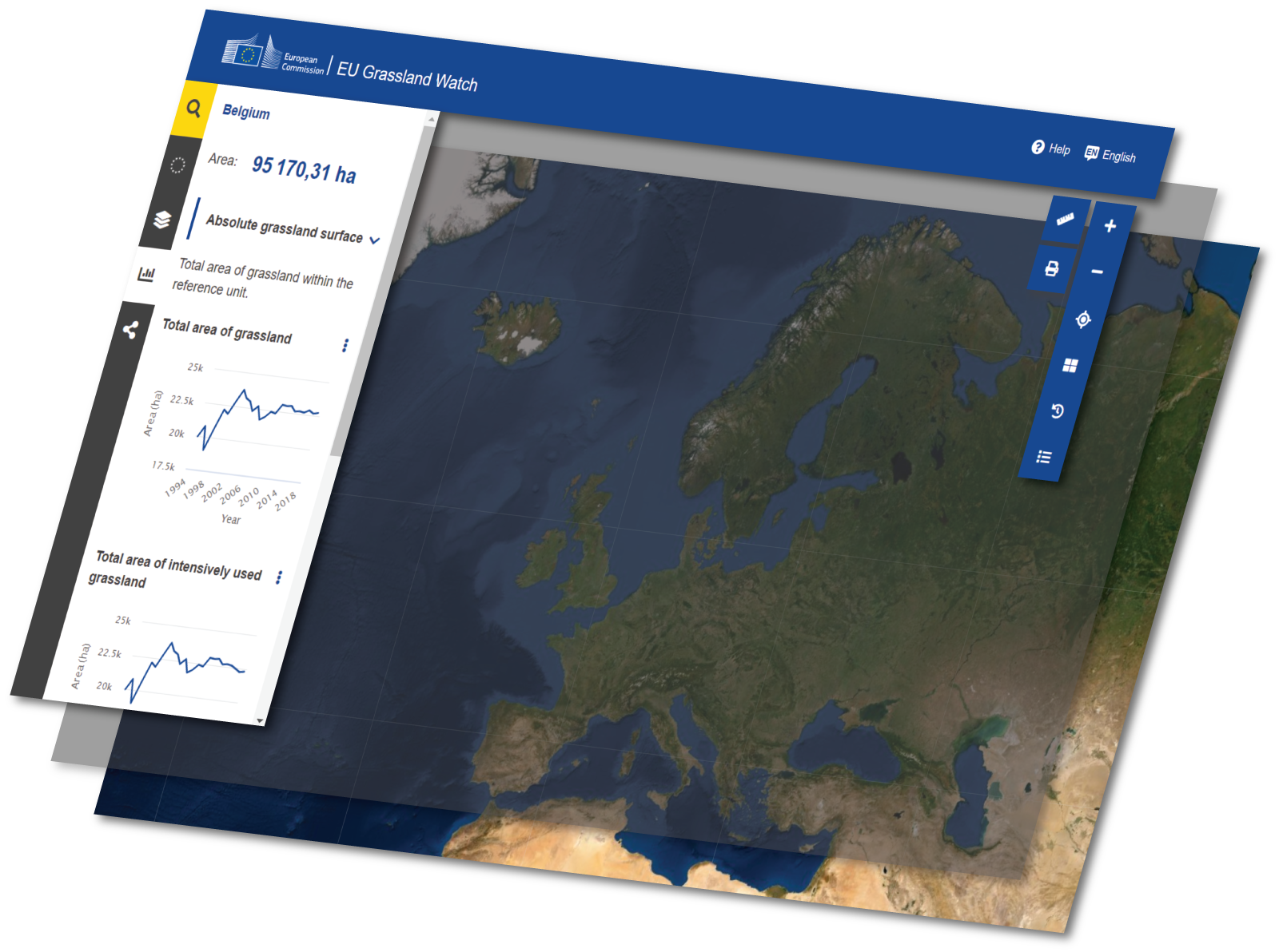


About
Natura 2000 is a network of protected sites in the 27 European Union (EU) Member States, designated under the legal regime of the EU Birds and Habitats Directives.
Its overall aim is to contribute to the conservation of biodiversity in the EU, and more specifically to enable the maintenance, or recovery to a favourable conservation status, of the species and habitats for which the sites are designated. Member States must ensure that the sites do not deteriorate. They must also put in place conservation objectives and carry out the necessary conservation measures, to ensure that these objectives can be achieved.
There are currently over 27 000 Natura 2000 sites across the EU. Information on the locations, their boundaries and the lists of species and habitats present in the sites can be explored in an interactive webtool: the Natura 2000 viewer [https://natura2000.eea.europa.eu/]. Furthermore, a dashboard (the Natura 2000 barometer [https://www.eea.europa.eu/data-and-maps/dashboards/natura-2000-barometer]) keeps track of the evolution of the Natura 2000 network in terms of area covered and number of sites per EU Member State, both on land and at sea.
Grasslands are natural or semi-naturals habitats comprising grasses, sedges, herbs and rushes. Traditionally managed as hay meadows or grazed pastures with a low fertiliser input, grasslands are key habitats for many rare and threatened species in Europe, including birds, butterflies and plants. About 12 000 Natura 2000 sites in Europe include an area of at least 1 of the 32 types of grassland habitats protected under the Habitats directive.
In addition to their outstanding value for biodiversity, well-managed grasslands provide many important ecosystem services, including carbon storage, ground water replenishment and protection against erosion.
Unfortunately, the biodiversity value of grasslands is declining as a result of farmland intensification (fertilisation, drainage, conversion to arable, etc.), rural abandonment and various other land use changes. Even within some of the Natura 2000 sites, species-rich grasslands continue to be lost despite their legal protection!
To ensure that grasslands within the Natura 2000 network are maintained, it is necessary to track their area and quality in near-real time at the patch level within each of the sites.
Images collected from satellites have long been used for observing land transformations, but it is only for less than a decade that there has been sufficient capacity to map field-scale inter annual changes, management practices and phenology reliably across the EU.
This service uses satellite images to produce annual land cover / land use maps and biophysical property and management information for each the selected Natura 2000 sites. The available images for a whole year are combined into monthly (or quarterly pre-Sentinel) composites which minimise cloud in optical data and reduce noise in SAR data. The composites are then processed to give the required products to characterise the Natura 2000 sites.
Key to this is Copernicus [https://www.copernicus.eu/en], the European Union’s programme for monitoring the Earth from space. Data is collected from a range of different sources, including a fleet of Sentinel satellites and in-situ sensors, with plans to maintain the programme into the foreseeable future. All data are made freely and openly available to any users. The data are also processed by Copernicus services to provide reliable and up-to-date information products to support a broad range of end user and downstream services. However, for the service to provide information back to 1994 it has been necessary to use data from the US Landsat system even though its observing capacity was not equivalent to that available today when combining Sentinel and Copernicus data.