Archive:LUCAS — a multi-purpose land use survey
This Statistics Explained article is outdated and has been archived - for recent articles on soil, land cover and land use see here.
- Published in Sigma - The Bulletin of European Statistics, 2010/01
The Land use/cover area frame survey (LUCAS) was initially developed to deliver, on a yearly basis, European crop estimates for the European Commission. With time, the survey has become essential in providing policymakers and statisticians alike with increasing amounts of data on different forms of land use in Europe and proved to be a useful tool in the area of environmental monitoring. Sigma asked Marjo Kasanko from Eurostat’s Farms, Agro-environment and Rural Development Unit to explain the origins, purpose and the future development of LUCAS.
Introduction
‘The LUCAS project was put into operation following the decision of the European Parliament and the Council in May 2000,’ said Ms Kasanko. ‘From the start, it aimed to develop a standard survey methodology (including sampling plans, nomenclature and data collection processes) that would allow us to obtain harmonised estimates of the land cover and land use at European Union (EU) level.’
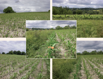
‘Perhaps one of the most interesting things about LUCAS is the fact that while conducting the survey, the surveyors do not ask any questions of the local residents, land owners and users. Instead, while visiting their assigned geographical spots, the surveyors record, also by taking photographs, what they encounter. This way we see whether the place is a town, field, forest or grassland. What is more, we can then differentiate whether the grass is a field, a lawn or a golf course,’ said Ms Kasanko. ‘This approach means that we create a minimum disturbance to land owners and farmers.’
New LUCAS survey

Based on the experience gained during the pilot phase (2000–07), initially involving 13 to 15 EU Member States (the first survey was held in 2001), a new LUCAS survey is currently under way. It is the largest LUCAS survey ever carried out, with 25 EU countries involved (Cyprus and Malta are not included because of their size) and over 230 000 survey points to be visited by the surveyors in the years 2008 and 2009.
‘The 2008 and 2009 survey points, designed by Eurostat, include many survey points from the previous LUCAS 2006 pilot survey, so that we can track the changes in land cover and land use over time,’ said Ms Kasanko. ‘The results will be reliable at EU level down to regions and provinces (so-called NUTS 2 and NUTS 3 levels), depending on the country.’
Ms Kasanko explained that as far as resulting statistics were concerned, the dataset would be unique. ‘The data are fully harmonised because the same definitions and the same methodology are used across Europe. Additionally, thousands of photos taken by our surveyors will create a separate, invaluable database.’
Flexible surveying methods
According to Ms Kasanko, the future of the survey looks very promising. LUCAS is fast becoming a multi-purpose platform with land cover and use data as its core activity. Flexible modules dealing with more specific themes, such as soil and biodiversity, would increasingly be integrated into the survey.
‘In 2009, for the first time, an ad hoc exercise called “LUCAS Soil 2009” was conducted. It will result in approximately 20 000 random soil samples being collected by the LUCAS surveyors at points of their visit and later analysed in a soil laboratory. The data will be used for assessing the quantity of organic carbon in soil and for updating the European soil map. This exercise is jointly organised by some of the main LUCAS data users — Eurostat, the Commission’s Directorate-General for the Environment and the Commission’s Joint Research Centre,’ explained Ms Kasanko.
‘The demand for national and particularly regional land cover/use statistics is growing fast,’ said Ms Kasanko. ‘In addition, data on land cover and land use are needed for various essential environmental and economic projects. Many of these are linked to the sustainable use of resources and to climate change.’
Further Eurostat information
Publications
- From farm to fork - Focus on sustainable agriculture and fisheries statistics - SIGMA - The Bulletin of European Statistics, 01/2010
- New insight into land cover and land use in Europe - Statistics in focus 33/2008
