
On seabed mapping
XVIII International Hydrographic Conference
Monaco, 23 April 2012
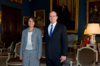
At the International Hydrographic Organisation ![]() , in Monaco, Commissioner Maria Damanaki presented the initiative that the European Commission is putting in place for the mapping of the seabed. To this aim, Commissioner Damanaki signed a Memorandum of understanding with the President of the IHO. In Monaco, the Commissioner also met Prince Albert II of Monaco, to hear about the work of the Monaco Foundation in its search for concrete and modern solutions to problems related to biodiversity and climate changes.
, in Monaco, Commissioner Maria Damanaki presented the initiative that the European Commission is putting in place for the mapping of the seabed. To this aim, Commissioner Damanaki signed a Memorandum of understanding with the President of the IHO. In Monaco, the Commissioner also met Prince Albert II of Monaco, to hear about the work of the Monaco Foundation in its search for concrete and modern solutions to problems related to biodiversity and climate changes.
Your Serene Highness, President, Secretary General of the Sea,
The world's maritime community has reasons to be grateful to Monaco's long-standing and leading worldwide role in the field of maritime affairs. Your Serene Highness, this is not only because of your well-known, well-appreciated and very effective efforts to protect the marine environment, but also because of the legacy of your great great grandfather, the first Prince Albert.
In inviting the International Hydrographic Office here to Monaco ninety one years ago, Prince Albert the First provided a service to humanity. We now have names and boundaries for all the seas, oceans and bays in the world. We have agreed standards for nautical charts. Who knows how many accidents have been avoided, lives saved and coastlines protected through the work of this organisation.
We are all aware that the marine economy is growing and has the potential to grow even further. All of us know that the sea-bottom is not only a hazard to navigation. It is a new frontier. It is crossed by cables and pipelines. It lies above reserves of gas and oil. It provides the foundations for the wind energy platforms that are springing up around our coasts. It hosts ecosystems such as cold water corals whose extent we only learned about recently. It cools hydrothermal vents where organisms thrive, that can withstand extreme heat or pressure, that grow without sunlight and whose potential as biocatalysts is only now beginning to be understood.
All of this represents an opportunity to make this the century of the sea. The oceans can contribute towards the clean energy we need if we are to avoid a climate catastrophe. They can deliver the protein we need for healthy diets. They can provide the stimulus we need to get our economies moving, challenging and rewarding jobs that meet the expectations of our young people.
To some extent this is already happening. Already 10% of wind platforms in Europe are being built offshore. The European Wind Energy Association reckon that by 2020 this will be 30% and 60% by 2030. The European Ocean Energy believe that there will be 314,000 direct jobs from other types of offshore energy - tide and wave - by 2050.
But, we need to make it easier for companies to invest in the sea. We need to lower costs, reduce risks and stimulate innovation. And of course we need to ensure that this expansion of the blue economy is sustainable. The resources are large but not infinite. The sea is a resource that has to be at the disposal of future generations. Not just ours.
And this is where marine knowledge comes in. Potential investors need to know whether the ocean floor is sand or rock, or what the ecosystem is like in order to assess any potential impact. They need to know for example the likelihood and severity of potentially damaging storms or tsunamis.
But, as you know, it can be very difficult to find who holds these data. It can take much time and effort to negotiate access to them and it can be a nightmare to create a coherent picture of a particular area out of observations with different baselines, units and formats. We have estimated that unlocking this patrimony of data would increase the competiveness of the European offshore activities by three hundred million euro each year.
This is why we embarked on our SEABED MAPPING INITIATIVE. We have now made a low resolution map of water depth in most European waters available to all – private companies, public authorities and researchers – who need it. This was patched together and processed from twenty different data providers who themselves processed surveys from a hundred and thirteen different surveying bodies.
Based on this experience we aim to go much further. By the end of 2014 we should have covered all European waters at double this resolution. This digital map will show the depth of water, the type of sediments, the whereabouts of minerals, the zones of human activity and the type of habitat. It will be accompanied by observations of temperature, salinity, chemical pollution and marine life.
The EU's new research programme Horizon 2020 can also contribute. We are aiming to lower the cost of monitoring and mapping, by encouraging the development of new sensors with automatic observations from boats or platforms, and of new technologies that can speed up the interpretation of video images of marine life.
An independent study performed on behalf of the Irish Government estimated that the economic benefits of mapping the seabed bring benefits four or five times the cost of the mapping.
A more recent United States study has estimated that every dollar invested in the US coastal mapping programme brings economic opportunities of 35 dollars.
And this is why we are signing this Memorandum of Understanding with your Organisation. To move to a more operational process where observations are assembled and maps maintained on a continuous and sustainable basis. To develop a structure where priorities are based on needs, expressed by industry, scientists and public authorities.
You have the technical expertise and I know that you too want to use this expertise for a wider scope than navigation.
Ladies and gentlemen, I look forward to working with you.
Thank you.
