Merging statistics and geospatial information, 2016 projects - Finland
Spatial statistics on Web2. Further development of the Oskari application and the Finnish national geoportal Paikkatietoikkuna from the viewpoint of statistical services; 2016 project; final report 30 January 2019
This article forms part of Eurostat’s statistical report on the Integration of statistical and geospatial information.
Full article
Problem
Staff of the national statistical authority had identified functionalities that they would like to have but which were not available in the existing application (Oskari) and portal (Paikkatietoikkuna).
Objectives
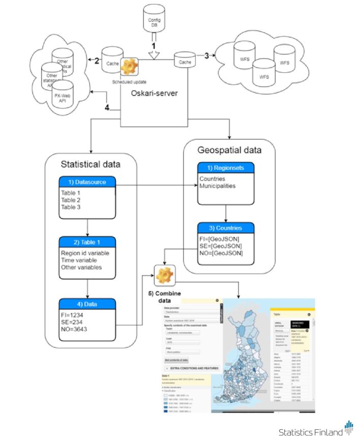
At the beginning of the project, the thematic map functions in Oskari were able to read only one specific data source (Sotkanet REST API). One of the principal objectives was to refactor the thematic map functions to be more general through the use of adapters so that any kind of statistical interface service could be used. For each type of interface service, a specific adaptor is required to read and interpret the statistical data and combine it with the geospatial data.
Otherwise, the action concentrated on the development of thematic map functions and other new functionalities of the existing application. The new functionalities were proportional symbols for area features, graphs, visualisation of time series and reporting as an embedded map.
The action also aimed to improve the user interface.
Method
The National Land Survey of Finland (Maanmittauslaitos) was responsible for designing the user interface and implementing the required changes in the Oskari application framework. The developments were made by user interface experts of the National Land Survey of Finland and of Statistics Finland.
The municipal key figures (Kuntien avainluvut) dataset was chosen for testing. An adaptor was developed that was specific for these data in order to combine them with geospatial data.
Results
The Oskari application was extended to use Statistics Finland’s API service for statistical tables. This was done by way of developing an adaptor which converts the data from the source (Kuntien avainluvut) into the structure/coding used by Oskari.
By the end of the project, the Oskari application included statistical data adapters for SDMX REST, Sotkanet and PX-Web API interface services.
The metadata from Kuntien avainluvut were translated into Swedish and English. Adaptations were made to the application such that all of the tables used by the thematic mapping application can be used in Finnish, Swedish and English.
The developments of the interface were fully completed by the end of the project. The developments were constrained to some extent because of the existing parts of the Paikkatietoikkuna geoportal, leading to many compromises.
Statistics Finland started its own pilot Oskari application that included the thematic mapping application.
Direct access to
