|
|

|
|
|
| |
28 February 2025
|
|
|
|
European Marine Observation and Data Network | EMODnet
|
|
|
|
|
|
|
|
|
|
|
|
|
Highlight
|
|
|
EMODnet for the European Oceans Pact
|
|
As a key EU pillar for Marine Knowledge and in situ marine data service of the European Commission (EC), DG MARE, EMODnet welcomes the European Ocean Pact and submitted an EMODnet response to the recent call for evidence which closed on 17 February 2025. The resulting EMODnet response is a collective response by the EMODnet Steering Committee, including the Secretariat, Central Portal and thematic and data ingestion coordinators and SC representatives. EMODnet was also a co-author to a response submitted by the European Ocean Observing System (EOOS) Steering Group.
|
|
|
|
|
|
|
|
|
|
|
|
EMODnet Service Updates
|
|
|
Technical Blog #4: Update on EMODnet’s progress on the 2nd anniversary of the launch of the unified EMODnet Portal
|
|
Just over two years ago, in January 2023, EMODnet took a bold step by transforming from seven distinct Thematic Portals—covering Bathymetry, Biology, Chemistry, Geology, Human Activities, Physics, and Seabed Habitats—into a single, unified web portal. Spearheaded by the EMODnet Central Portal Technical Team and thematic coordinators, this transition consolidated marine data access, simplifying user experience and enhancing efficiency.
|
|
|
|
|
|
|
|
|
|
|
|
EUSeaMap Evolution: 2012 to 2023 - A Storymap
|
|
A detailed map of the seabed and its associated habitats is essential for the sustainable management of our oceans. One of EMODnet Seabed Habitats main products is EUSeaMap, which is a broad-scale habitat map for all European sea basins, as well as the Caribbean. It represents a comprehensive, free and ready-to-use classified map of physical seabed habitats. There is an ongoing requirement to update this map with new and revised input data, in order to improve spatial coverage and resolution, thereby enhancing its usefulness. This storymap illustrates the different phases of EUSeaMap from the first iteration in 2012 to the most recently published version - EUSeaMap 2023.
|
|
|
|
|
|
|
|
|
|
|
|
EMODnet Bathymetry Contributing to Seabed 2030 Arctic Seabed Mapping
|
|
EMODnet Bathymetry has consistently served as a key regional centre and significant contributor to the Nippon Foundation – GEBCO Seabed 2030 Project. Now, EMODnet Bathymetry has contributed its harmonized Digital Terrain Model (DTM) to a recently released, updated, Seabed 2030 map of the Arctic Seabed.
|
|
|
|
|
|
|
|
|
|
|
|
Extensive wreck data set now available on EMODnet
|
|
A new data set containing over 67,000 charted, uncharted, wrecks from around the world is now available on EMODnet. The data set is maintained by the UK Hydrographic Office and receives regular quarterly updates.
|
|
|
|
|
|
|
|
|
|
|
|
Contaminant data and maps: How to make the most of the Map viewer
|
|
New maps for contaminants are accessible on the EMODnet Map Viewer. The main purpose of these visualisations is to show the spatial and temporal variability of the data in the water column, in biota and in sediment. Currently, maps are available for 12 contaminants in all European sea basins and beyond. These contaminants belong to the following groups of variables: Heavy metals, hydrocarbons, pesticides and biocides, and antifouling agents. To learn more about EMODnet Chemistry's maps and data collections, follow us on this guided tour to explore the features of the Map Viewer.
|
|
|
|
|
|
|
|
|
|
|
|
New EMODnet Geology coastal resilience/vulnerability data product
|
|
Improved knowledge of coastal response to marine processes (resilience) and risk of coastal change (vulnerability) is crucial for coastal management in response to climate change. The new EMODnet Geology coastal resilience/vulnerability data product is a pan-European visualization, at variable scales, derived from a database of > 900 studies. Lower, intermediate and higher levels of coastline resilience/vulnerability are shown, with information on the wide range of methodological approaches used in their assessment indicating that geology and coastline shape (geomorphology) are key factors.
|
|
|
|
|
|
|
|
|
|
|
|
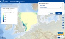
New EMODnet Biology product: Habitat suitability of reef-forming species in the North Sea
|
|
This new product, developed by Deltares in cooperation with the Dutch Ministry of Infrastructure and Transport, identifies areas suitable for reef habitats in the North Sea based on four key species occurrences and environmental variables such as bathymetry, grain size distribution, temperature and salinity.
|
|
|
|
|
|
|
|
|
|
|
|
EMODnet Biology is wrapping up two years of Phase V and preparing for the next phase
|
|
EMODnet Biology is 3 months away from ending the two years of work planned for Phase V. During the next few weeks, the final deliverables will be published.
|
|
|
|
|
|
|
|
|
|
|
|
|
European Atlas of the Seas
|
|
|
Monthly dive into the European Atlas of the Seas
|
|
The Atlas team released a new tool – ‘My Notes’ – that allows users to annotate maps. Twelve new map stories are now available in the Atlas. A new quiz and a recently developed poster were added to the Atlas’ Teachers Corner. Four Maps of the Week’ were published in February: ‘Marine Natura 2000 Sites - Blue Carbon’, ‘Large Marine Ecosystems (LMEs)’, ‘Plastic pollution’ and ‘Mission Actions and European Ocean Days 2025’.
|
|
|
|
|
|
|
|
|
|
|
|
|
EMODnet and the European Digital Twin Ocean
|
|
|
EMODnet and the European Digital Twin Ocean (EU DTO) at EU Ocean Days 2025: Advancing Digital Ocean Innovation
|
|
EMODnet and the EU DTO will be showcased at European Ocean Days 2025, a week-long event organized by the European Commission for marine and maritime stakeholders to convene, exchange and advance marine knowledge, sustainability, and innovation. As part of this broader initiative, EMODnet and EU DTO (underpinned by the EDITO initiative) will be showcased during Mission Restore Our Ocean and Waters Forum, taking place on 4 March 2025. EDITO will host an interactive booth, highlighting its critical role in digital ocean research and data accessibility. Multiple EMODnet Coordinators, Secretariat and wider experts will also represent EMODnet and EMODnet’s role in EU DTO at the Marine Knowledge for the Ocean Pact event on 7 March 2025.
Visit the EU Ocean Days 2025 website for more information: https://research-and-innovation.ec.europa.eu/events/upcoming-events/mission-ocean-and-waters-forum-and-related-events-2025-03-03_en
|
|
|
|
|
|
|
|
|
|
|
EMODnet and the UN Ocean Decade
|
|
|
Open Call for Side Events at the 2025 UN Ocean Conference
|
|
The 2025 UN Ocean Conference invites Member States, UN entities, Intergovernmental Organizations, and accredited non-governmental stakeholders to organize side events—either in-person or virtually. These events offer a platform to share knowledge, showcase solutions, and accelerate action toward achieving SDG 14: Life Below Water.
Side events should align with the conference theme: “Accelerating action and mobilizing all actors to conserve and sustainably use the ocean” and should explore innovative approaches to ocean sustainability. For more information visit: https://sdgs.un.org/conferences/ocean2025/side-events
|
|
|
|
|
|
|
|
|
|
|
|
|
EMODnet at recent events
|
|
|
Pollutant maps: Consultation of EMODnet Chemistry board of experts on the Marine Strategy Framework Directive (MSFD)
|
|
In February 2025, Athanasia (Sissy) Iona, Head of the Hellenic National Oceanographic Data Centre and EMODnet Data Ingestion Scientific Coordinator presented the pollutant maps in the EMODnet Map Viewer to the EMODnet Chemistry Board of experts on the EU Marine Strategy Framework Directive (MSFD). She highlighted the recent improvements and new visualisations. EMODnet Chemistry has been interacting with stakeholders involved in the Regional Seas Conventions and the MSFD since its launch in 2009. In 2017, this contact was formalised with the establishment of the Board of experts on the MSFD. The role of the panel is to advise the Consortium on the scope and definition of data products and services from the perspective of their use in the MSFD assessments. Find out more about the work of the MSFD board on the EMODnet Portal.
|
|
|
|
|
|
|
|
|
|
|
|
|
Upcoming events
|
|
|
|
|
|
|
Surveys and Consultations
|
|
|
EMODnet Survey
|
|
Your Feedback Matters! EMODnet continues to evolve to better serve your needs. Our survey is designed to gather your valuable feedback on our services. Whether you have spotted a technical bug, or you visited to search for the latest data products or use cases, we want to hear from you! Your input is crucial in enhancing our website's user-friendliness and usability. Share your thoughts and help us improve your EMODnet experience by filling out our survey!
|
|
|
|
|
|
|
|
|
|
Prepared and published by the EMODnet Secretariat.
Privacy Statement
The European Marine Observation and Data Network (EMODnet) is financed by the European Union under Regulation (EU) 2021/1139 of the European Parliament and of the Council of 7 July 2021 establishing the European Maritime, Fisheries and Aquaculture Fund.
Subscribe | Unsubscribe | Legal notice
|
|
 |
|