,_2010,_BE,_BG,_DE,_EE,_IE,_IT,_NL,_AT,_PL,_SK_and_NO.jpg)
, 2010, BE, BG, DE, EE, IE, IT, NL, AT, PL, SK and NO.jpg&body=Statistics Explained - Soil erosion maps as collected through the EIONET-SOIL network (tonnes per ha per year), 2010, BE, BG, DE, EE, IE, IT, NL, AT, PL, SK and NO.jpg %0A https%3A%2F%2Fec.europa.eu%2Feurostat%2Fstatistics-explained%2Findex.php%3Ftitle%3DFile%3ASoil_erosion_maps_as_collected_through_the_EIONET-SOIL_network_%28tonnes_per_ha_per_year%29%2C_2010%2C_BE%2C_BG%2C_DE%2C_EE%2C_IE%2C_IT%2C_NL%2C_AT%2C_PL%2C_SK_and_NO.jpg)
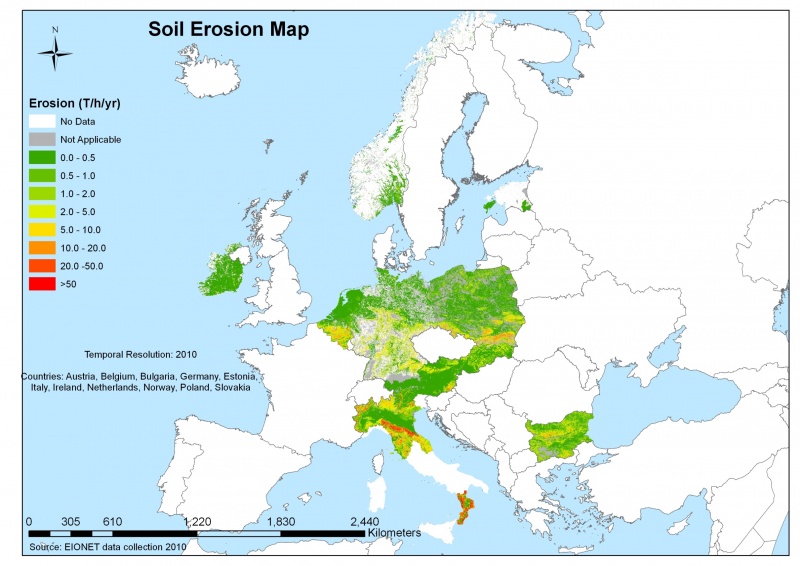
File:Soil erosion maps as collected through the EIONET-SOIL network (tonnes per ha per year), 2010, BE, BG, DE, EE, IE, IT, NL, AT, PL, SK and NO.jpg

Size of this preview: 800 × 566 pixels. Other resolutions: 320 × 226 pixels | 2,420 × 1,711 pixels.
Original file (2,420 × 1,711 pixels, file size: 675 KB, MIME type: image/jpeg)
File usage
The following page uses this file:
,_2010,_BE,_BG,_DE,_EE,_IE,_IT,_NL,_AT,_PL,_SK_and_NO.jpg&oldid=239235)
,_2010,_BE,_BG,_DE,_EE,_IE,_IT,_NL,_AT,_PL,_SK_and_NO.jpg)
,_2010,_BE,_BG,_DE,_EE,_IE,_IT,_NL,_AT,_PL,_SK_and_NO.jpg&action=edit&redlink=1)
,_2010,_BE,_BG,_DE,_EE,_IE,_IT,_NL,_AT,_PL,_SK_and_NO.jpg&action=history)