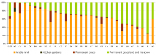
File:Cropping patterns EU-27, 2007.png

Size of this preview: 799 × 284 pixels. Other resolutions: 320 × 114 pixels | 886 × 315 pixels.
Original file (886 × 315 pixels, file size: 6 KB, MIME type: image/png)
Cropping patterns in the EU-27, 2007
Graph created with data from July 2010
Most recent data available now, see:
Farmland: Number of farms and areas by size of farm (UAA) and region
File usage
The following page uses this file: