,_2000,_2006,_2007,_EU-27,_NUTS_2.png)
, 2000, 2006, 2007, EU-27, NUTS 2.png&body=Statistics Explained - Share of UAA in LAU 2 with low population density and remote from urban centre (%), 2000, 2006, 2007, EU-27, NUTS 2.png %0A https%3A%2F%2Fec.europa.eu%2Feurostat%2Fstatistics-explained%2Findex.php%3Ftitle%3DFile%3AShare_of_UAA_in_LAU_2_with_low_population_density_and_remote_from_urban_centre_%28%2525%29%2C_2000%2C_2006%2C_2007%2C_EU-27%2C_NUTS_2.png)
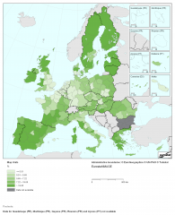
File:Share of UAA in LAU 2 with low population density and remote from urban centre (%), 2000, 2006, 2007, EU-27, NUTS 2.png
,_2000,_2006,_2007,_EU-27,_NUTS_2.png&diff=prev&oldid=132560)
,_2000,_2006,_2007,_EU-27,_NUTS_2.png&direction=prev&oldid=132560)

Size of this preview: 487 × 600 pixels. Other resolutions: 195 × 240 pixels | 2,056 × 2,533 pixels.
Original file (2,056 × 2,533 pixels, file size: 310 KB, MIME type: image/png)
Map created with data from 2006-2008.
Data extracted in March 2013. Source:
EuroRegionalMap 2.2 (EuroGeographics)
Urban morphological zones 2000 (EEA)
Urban Audit 2007 (DG Regio)
SRTM mosaic Europe (JRC)
CORINE Land Cover 2006 (2000 for Greece) (EEA)
File usage
The following file is a duplicate of this file (more details):
,_2000,_2006,_2007,_EU-27,_NUTS_2.png)
,_2001,_2006,_2007,_EU-27,_NUTS_2.png)
There are no pages that use this file.
,_2000,_2006,_2007,_EU-27,_NUTS_2.png&oldid=132560)
,_2000,_2006,_2007,_EU-27,_NUTS_2.png)
,_2000,_2006,_2007,_EU-27,_NUTS_2.png&action=edit&redlink=1)
,_2000,_2006,_2007,_EU-27,_NUTS_2.png&action=history)