Farm structure (ef)

National Reference Metadata in ESS Standard for Quality Reports Structure (ESQRS)

Compiling agency: Hellenic Statistical Authority (ELSTAT) 


Eurostat metadata
Reference metadata
1. Contact
2. Statistical presentation
3. Statistical processing
4. Quality management
5. Relevance
6. Accuracy and reliability
7. Timeliness and punctuality
8. Coherence and comparability
9. Accessibility and clarity
10. Cost and Burden
11. Confidentiality
12. Comment
Related Metadata
Annexes (including footnotes)


For any question on data and metadata, please contact: Eurostat user support

Download


1. Contact Top
1.1. Contact organisation
Hellenic Statistical Authority (ELSTAT) 
1.2. Contact organisation unit
Primary Sector Statistics Division / Structure of Agricultural and Livestock Holdings Section 
1.5. Contact mail address
Pireos 46 & Eponiton Str.,18510 – Piraeus, P.O.Box 80847 


2. Statistical presentation Top
2.1. Data description
1. Brief history of the national survey 
The Farm Structure Survey (FSS) is a wide range, periodic statistical survey carried out in two forms:

•  A basic survey (Agricultural-Livestock Census), conducted every ten years

•  A sample survey conducted on a two-year basis till 2010 and on a three-year basis since, in the period between Agricultural-Livestock Censuses.


Census surveys were carried out in the years: 1921, 1929, 1950, 1961 and every 10 years since. Sample surveys were carried out in: 1966/67, 1977/1978, 1983 and since then, every 2 years until 2010. From 2010 onward the sample survey is carried out every 3 years.

The purpose of the FSS is to determine the basic structural features of the agricultural and livestock holdings. Data are collected, according to Community legislation, on:

•  General characteristics

•  Utilized agricultural area

•  Livestock

•  Variables of special interest, such as labour force, rural development issues, management and cultivation methods.


The development of the agricultural holdings’ structure constitutes the main element upon which the National and Community policies in the Agricultural Sector are based.

The unit of the survey is the agricultural and/or livestock holding. The sampling frame, which was used for the 2016 FSS, was the updated Register of Agricultural and Livestock Holdings compiled by ELSTAT. The sampling method used is the single random stratified sampling, according to a stratification scheme based on the Regional Unit, the Typology and the Economic size, expressed through the Standard Output, of the holdings.

Aggregated data are tabulated and published online at the NUTS 1 (Large Geographical Area), NUTS 2 (Region) and Regional Unit level.


2. Legal framework of the national survey 
- the national legal framework Act no 6184/Γ2-492/Government Gazette (GG) no 2193/B/15-07-2016 on the “Approval, proclamation, assignment and distribution of costs for conducting the farm survey structure for the year 2016, as well as approval of using statistical representatives and determination of their fee for the year 2016” as corrected by the Government Gazette (GG) no 716/B/08-03-2017. The above-mentioned national legislation deals with the scope and the coverage of FSS, assigns ELSTAT the responsibility for the surveys, and determines the obligations of the respondents with respect to the survey and identification, as well as the protection and the obligations of enumerators. In addition, it includes administrative and financial provisions and provisions relevant to the right of access to administrative data.
- the obligations of the respondents with respect to the survey Private sector legal entities, associations of persons as well as natural persons entities are obliged to secure access for the ELSS representatives, to all data sources or records kept either in written or digital, magnetic or other similar form, and to provide timely and accurately any data or raw information requested by those representatives within their competence. 
- the identification, protection and obligations of survey enumerators The enumerators were (a) private short-term contractors and (b) employees of Municipalities and other public services.

a) The private short-term contractors were selected from the Enumerators Register of ELSTAT that is built up every 8 months, after a public invitation launched through the mass media. The selection takes place in compliance with a pre-defined system of rules. The applicants fill in and submit their applications online and are ranked through a computerized system, on the basis of clear and objective criteria (e.g. availability/employment, previous experience in statistical works, level of education, etc). The applicants are selected on the basis of the ranking lists.

b) The employees of Municipalities and other public services were selected on the basis of their experience on statistical surveys in the agricultural sector, their knowledge of the territory and the local situation in agriculture as well as their agronomic background.

Upon signing of a contract, both categories of selected enumerators were bound to fulfill their obligations (to complete the questionnaires and to check their quality) within the defined time frame and in the best possible manner. They were also bound to observe the statistical confidentiality procedures of ELSTAT, for all collected data.

ELSTAT provided each enumerator with an “Associate” identification card issued by the Administrative Support Division of ELSTAT. 

2.2. Classification system

[Not requested]

2.3. Coverage - sector

[Not requested]

2.4. Statistical concepts and definitions
List of abbreviations
ELSTAT     Hellenic Statistical Authority

GG            Government Gazette

EU             European Union

EC             European Commission

FSS           Farm Structure Survey

UAA          Utilised Agricultural Area

LSU           Livestock Units

OPEKEPE    Payment and Control Agency for Guidance and Guarantee Community Aid

IACS          Integrated Administration and Control System

OCR          Optical Character Recognition

ELSS          Hellenic Statistical System

SCC           Statistical Confidentiality Committee

2.5. Statistical unit
The national definition of the agricultural holding
The agricultural holding is a single unit, both technically and economically, which has a single management and which undertakes the following agricultural activities, within the economic territory of Greece, either as its primary or secondary activity:

-    Growing of non-perennial crops

-    Growing of perennial crops

-    Plant propagation

-    Animal production

-    Mixed farming

-    Support activities to agriculture and post-harvest crop activities

2.6. Statistical population
1. The number of holdings forming the entire universe of agricultural holdings in the country
The total number of holdings in the Agricultural Register of ELSTAT is 731,182 holdings. 


2. The national survey coverage: the thresholds applied in the national survey and the geographical coverage
The survey was conducted in all districts of Greece and the target population is all the agricultural, livestock or mixed holdings, which satisfy the following thresholds:

a) At least 0.1 ha of utilized land (A_3_1) or at least 0.05 ha of greenhouses (B_1_7_2+B_1_8_2+B_4_7), regardless of the production type, ownership, or the location of the holding, or

b) At least:

- 1 cow (C_2_6+C_2_99) or

- 2 other "large animals" of any type and age (oxen, horses, donkeys, mules) (C_1+C_2_1+C_2_2+C_2_3+C_2_4+C_2_5), or

- 5 "small animals" (sheep (C_3_1), goats (C_3_2), pigs (C_4)) of any age and type, or

- 50 poultry birds (C_5), or

- 50 female rabbits (C_6), or

- 20 hives of “domestic” or “European” bees (C_7) or

- 5 ostriches (C_5_3_4).

c) Cultivates mushrooms (B_6_1)


3. The number of holdings in the national survey coverage 
The number of holdings in the population covered by FSS 2016 is 684,954. 


4. The survey coverage of the records sent to Eurostat
The coverage of the records sent to Eurostat is the same as the national survey coverage. 


5. The number of holdings in the population covered by the records transferred to Eurostat
The number of holdings in the population covered by the records transferred to Eurostat for the FSS 2016 is 684,954. 


6. Holdings with standard output equal to zero included in the records sent to Eurostat
The number of records with standard output equal to zero for the FSS 2016 is 516 holdings.

These holdings which are eligible to be included in the survey are:

- 512 holdings with fallow land and/or permanent grassland no longer in production purposes which is kept in good agricultural and environmental conditions,

- 2 holdings with only "other livestock" not economically valued. These are holdings with hares, deers and wild boars recorded under "other livestock".

- 2 holdings with no agricultural activities. These are two of the 52 ‘special common land units’ (see 8.1.4), namely the units corresponding to the predominantly urbanized NUTS 3 Regional Units: Kentrikos Tomeas Athinon (EL303), Notios Tomeas Athinon (EL304).” 


7. Proofs that the requirements stipulated in art. 3.2 the Regulation 1166/2008 are met in the data transmitted to Eurostat
The threshold for utilised agricultural area is lower than 1 hectare,  therefore art. 3.2 is not applicable.


8. Proofs that the requirements stipulated in art. 3.3 the Regulation 1166/2008 are met in the data transmitted to Eurostat
The national physical thresholds regarding crops and animals for the FSS 2016, as well as all previous FSS, are lower than the ones in Annex II of the Regulation (EC) 1166/2008, therefore the relevant data transferred to Eurostat meet the requirements of art. 3.3 of the Regulation. 
2.7. Reference area
Location of the holding. The criteria used to determine the NUTS3 region of the holding
The most important parcel of the holding (in terms of production value) is used to determine the NUTS3 region of the holding. 
2.8. Coverage - Time
Reference periods/dates of all main groups of characteristics (both included in the EU Regulation 1166/2008 and surveyed only for national purposes)
The reference period for the 2016 Farm Structure Survey, as regards crops, labour force and other characteristics was the cultivation period form 1st October 2015 until 30th September 2016. The reference date as regards animal capital of the holding was 1st November 2016.The reference period for the rural development measures was the 3-year period 2014-2016. 
2.9. Base period

[Not requested]


3. Statistical processing Top
1.Survey process and timetable
See annex 3-1.


2. The bodies involved and the share of responsibilities among bodies
ELSTAT had the full responsibility for carrying out FSS 2016. Appropriate assignments were delivered among the various Divisions of the Central Office and the Regional Offices.

More specifically:

-  the Structure of Agricultural and Livestock Holdings Section/ Primary Sector Statistics Division had the overall responsibility for the survey and was directly responsible for every step except the ones mentioned below.

-  the Methodology, Analysis and Research Section/ Organization, Methodology and International Relations Division was responsible for steps 1b, 2a, 4e.

-  the Regional Offices carried the burden for step 2f, 3a, 4a.

-  the Applications Development Section/ Informatics Division was responsible for step 5a, 5c. 


3. Serious deviations from the established timetable (if any)
No deviations from the established calendar were observed.


Annexes:
3-1.Survey timetable
3.1. Source data
1. Source of data
The data were collected through a sample survey covering about 12% of the target population using one-stage stratified sampling, except for the data on common land which were obtained from an administrative source (IACS register from OPEKEPE).


2. (Sampling) frame
The Sampling Frame, which was used in this survey, was the updated Register of Agricultural Holdings of ELSTAT (Farm Register) as this resulted from the Agricultural Census of 2009-2010 and the relevant updating procedures hence.

The Farm Register is a statistical register generated and updated periodically during the Agricultural Censuses. Furthermore, the Farm Register is updated from administrative sources (OPEKEPE), as well as other surveys conducted by ELSTAT such as the FSS (conducted every three years) and the specialized national annual agricultural surveys.

The Farm Register is a list frame.

The sampling frame for the 2016 FSS was based on the latest available version of the Farm Register. Data from specialized national annual agricultural surveys were compared and crosschecked to those of the Farm Register based on the identification data of the holder.

In total 3,467 holdings were added from OPEKEPE and 515 from the specialized national annual agricultural surveys.


3. Sampling design
3.1 The sampling design
The sampling method used by ELSTAT is the one-stage stratified random sampling (probability design), where the sampling unit is the agricultural, livestock or mixed holding.

The sampling units were drawn randomly from the sampling frame. In detail, in each stratum the sample has been selected with equal probabilities by systematic random sampling from the population of holdings belonging to this stratum. The holdings were ordered within strata according to the total Standard Output (SO, in esu) of the holding.

3.2 The stratification variables
According to this sampling scheme and for holdings included in the Register of ELSTAT, the strata were created by the combination of the following stratification criteria:
  • The Regional Unit of the holdings (74 Regional Units in Greece). The 74 regional units are a national level, in the most part equivalent to, but in some cases more detailed than NUTS 3. For the transition to NUTS 3 (52 regional units) some regional units are merged.
  • The particular type of farming according to the technical and economic orientation of holdings
  • The economic size of holdings was divided into 6 classes. The economic size has been defined by the total Standard Output (SO) calculated in ESU (1 ESU=1,200 Euro)


Table 1: Classes of holdings’ size determined by their total standard output (SO)

Classes Area with crops in hectares
 01   Less than 2 ESU
02  From 2 to less than 6 ESU
03  From 6 to less than 14 ESU
04  From 14 to less than 29 ESU
05  From 29 to less than 65 ESU
06  Equal to or greater than 65 ESU


4,878 holdings included in the Register of ELSTAT, whose total SO is equal to zero, were stratified as follows:

  • By Regional Unit by size class of holdings: In each Unit the crop holdings were stratified into 9 size classes, according to their size, determined by their area with crops, as follows:


Table 2: Classes of holdings’ size determined by their area with crops

Classes  Area with crops in hectares
11  Less than 1 hectare
12  From 1 to less than 2 hectares
13  From 2 to less than 3 hectares
14  From 3 to less than 5 hectares
15  From 5 to less than 10 hectares
16  From 10 to less than 20 hectares
17  From 20 to less than 30 hectares
18  From 30 to less than 50 hectares
19  Equal to or greater than 50 hectares
3.3 The full coverage strata
The following categories of holdings have been surveyed exhaustively:
  • Holdings with economic size more than 65 ESU (6,084 holdings).
  • Holdings breeding ostriches, included in the Register of the ELSTAT (27 holdings).
  • Livestock and crop holdings that were included in the Register of Agricultural Holdings of  ELSTAT that had been enriched by OPEKEPE and other  ELSTAT surveys (3,982=3,467 holdings from OPEKEPE + 515 holdings from other ELSTAT surveys) for which their economic size and type of farming were unknown.
3.4 The method for the determination of the overall sample size
From the total population of holdings, an initial sample of 83,170 holdings was selected from the Register of Agricultural Holding of ELSTAT, plus 3,982 holdings from the Register of OPEKEPE and other ELSTAT surveys. In addition, 12,988 reserve holdings were selected from the Register of ELSTAT as reserve sample and 1718 new holdings were added. In total, the gross sample size amounts to 101,858 holdings. The decision for determining the sample size was based on financial criteria and on several precision criteria (EC. Regulation 1166/2008) as follows:

a)  At regional level (NUTS II), the relative standard error of the size of the arable land of a certain crop characteristic should be less than 5%, when the size of the land of this certain characteristic is greater than 7.5% of the Region’s utilized agricultural area.

b) At regional level (NUTS II), the relative standard error of the capital livestock units of a certain kind of livestock should be less than 5%, when the livestock units of this certain kind of livestock exceeds 7.5% of the total livestock units in the region, under the condition that the certain kind of livestock in the region exceeds 5% of the certain kind of livestock at country level.

3.5 The method for the allocation of the overall sample size
In each separate Geographical Region (NUTS II), the sample belonging to sampling strata was distributed into the strata based on the Neyman allocation. In detail, the following formula was used for the distribution of the sampling units in each separate stratum:

where is the overall sample size in each region (NUTS II), nh is the sample size at stratum Nh is the population (number of holdings) of the stratum  h  and Sh is the standard deviation of the standard output (SO) of the holdings in the stratum h.

For the crop holdings belonging to the Register of the ELSTAT and of the Greek Ministry of Rural Development and Food, in the above formula, the value of Sh is the standard deviation of the arable land of the holdings belonging to the stratum h.

3.6 Sampling across time
A new sample is drawn for every new survey conducted.

A complementary (reserve) sample was also drawn in order to replace holdings in the following cases:

  • When the holding was sold/rented and merged with other holding
  • When the holding had been temporarily or permanently closed down
  • When the holding changed location and the new location is in a different Municipality.
  • When the holder is unknown, could not be reached and/or the sampling unit has been misclassified in the agricultural sector.
  • When the holder refused to give the required information (Unit non-response).
3.7 The software tool used in the sample selection
Microsoft Excel 
3.8 Other relevant information, if any
None.


4. Use of administrative data sources
4.1 Name, time reference and updating
Common land: Payment and Control Agency for Guidance and Guarantee Community Aid (OPEKEPE), Ministry of Rural Development and Food. OPEKEPE is the body responsible for the administration and maintenance of IACS for Greece. Data are collected on an annual basis through applications submitted by the beneficiaries. 
4.2 Organisational setting on the use of administrative sources
All public services and entities of the public sector are obliged to allow access to all administrative data sources, public registers and records, kept by them either in hardcopy, electronic, magnetic or other media. ELSTAT is provided access to the raw data and information.

All data and information referred herein are used by ELSTAT and the other members of ELSS for the production of official statistics as specified in the Regulation of Statistical Obligations. 

Administrative data specifications are determined by the needs of the pertinent agency. ELSS members are not customarily able to intervene in these procedures; however there is the possibility to do so, usually within the frame of special interagency collaborations. Even in these cases, though, differences in the data characteristics imposed by legal requirements (national and/or EU) are not easy to bridge.

4.3 The purpose of the use of administrative sources
Common land data collected from OPEKEPE were used to replace the survey on this characteristic. Special common land units were created to accommodate these data.


4.4 Quality assessment of the administrative sources
  Method  Shortcoming detected Measure taken
- coherence of the reporting unit (holding)   Given the nature of the variable for which administrative data were used (common lands) as well as the way these were introduced in the FSS data (as special units) differences in population coverage, and problems related to the incoherence of the statistical units and the linking of the two databases were not considered significant.   
- coherence of definitions of characteristics   The main problem was to ascertain the correspondence between the definitions used by the administrative source and those of FSS.  Considering the key difference in the definition of the reporting unit between OPEKEPE and FSS, aggregation up to the NUTS 3 level, into special common land units, was the only way to obtain common land data useful within the FSS context.
- coverage:      
  over-coverage      
  under-coverage      
  misclassification      
  multiple listings      
- missing data      
- errors in data      
- processing errors      
- comparability      
- other (if any)      


4.5 Management of metadata
Access to the OPEKEPE data is restricted. Metadata are available to external users (such as ELSTAT) upon request only.
4.6 Reporting units and matching procedures
The reporting unit for OPEKEPE is the farmer/holder that is the physical or legal person or group of physical or legal persons, regardless of the legal status assigned to that group and its members by national law, who practice agricultural production and whose agricultural production units are located in Greece. 

As mentioned in point 4.4 above, direct record matching was not feasible so common land is aggregated at NUTS 3 regional level into special common land units.

4.7 Difficulties using additional administrative sources not currently used
None.
3.2. Frequency of data collection
Frequency of data collection
The data of the Farm Structure Survey are collected every three years. 
3.3. Data collection
1. Data collection modes
The data of the FSS2016 were collected by means of face-to-face interviews with the owners of the agricultural holdings, based on a specially designed questionnaire.

The survey questionnaire was designed in such a way so as to satisfy both national and Community needs for statistical information. It covered all variables stipulated in Regulation 1166/2008 which must be analyzed, thus helping drawing the Hellenic agricultural policy.

The questionnaire was designed taking into consideration comments and observations made by the main data users (Ministry of Rural Development and Food, Ministry of Environments and Climate Change), as well as by other Divisions of ELSTAT (Division of Methodology and Organization, Division of Informatics, Division of Statistical Information and Publication, Division of National Accounts).


2. Data entry modes
After the collection of the questionnaires, the data, by means of OCR (optical character reading), were entered into the electronic database. Data entry was followed by a primary visual validation in order to identify and dully correct any OCR errors. 


3. Measures taken to increase response rates
Methods employed towards reducing the non-response rate were:
  • Updating the Farm Register so as to have valid contact information
  • Contacting the interviewees prior to the actual interview to ensure their presence.
  • Training of the enumerators on the personal interview procedure
  • Contacting non-respondents by telephone at a later date, and if possible completing the interview, especially for large holdings and holdings belonging to exhaustively surveyed strata.

For cases where the holder refused to provide information, the interviewer had instructions to insist and inform the holder about the Greek Statistical Law that obliges the surveyed person to provide the required statistical information. If the holder continued to refuse to cooperate then the interviewer had to inform the Supervisor in order to decide the proper action to be taken against the holder.

In cases in which it was impossible to collect statistical information from certain sampling units, units included in the complementary sample replaced these cases.


4. Monitoring of response and non-response*
1 Number of holdings in the survey frame plus possible (new) holdings added afterwards

In case of a census 1=3+4+5

706,575
2 Number of holdings in the gross sample plus possible (new) holdings added to the sample

Only for sample survey, in which case 2=3+4+5

101,858
3 Number of ineligible holdings

6,104

3.1 Number of ineligible holdings with ceased activities

This item is a subset of 3.

5,741
4 Number of holdings with unknown eligibility status

4>4.1+4.2

2,269
4.1 Number of holdings with unknown eligibility status – re-weighted 0
4.2 Number of holdings with unknown eligibility status – imputed 0
5 Number of eligible holdings

5=5.1+5.2

93,485
5.1 Number of eligible non-responding holdings

5.1>=5.1.1+5.1.2

7,862
5.1.1 Number of eligible non-responding holdings – re-weighted 7,739
5.1.2 Number of eligible non-responding holdings – imputed 123
5.2 Number of eligible responding holdings 85,623
6 Number of the records in the dataset 

6=5.2+5.1.2+4.2

85,746

 * the figures exclude the 52 common land units

5. Questionnaire(s) - in annex
 See two annexes.


Annexes:
3.3-5. FSS 2016 English Questionnaire
3.3-5. FSS 2016 Greek Questionnaire
3.4. Data validation
Data validation
Errors in individual observations were identified and corrected during the two main phases of Processing:
  • Data Processing and Validation by the Regional Statistical Offices
  • Quality Controls at Regional Unit level by the Central Service

During the Validation phase all values were checked for acceptability and consistency. The estimated gross error rate was 5 errors per questionnaire, including all types of errors from simple misspelling of a postal code or omission to fill-in a total to erroneous values being entered. The data were validated according to the following procedure:

1. Logical and completeness checks of the questionnaires in the Regional Statistical Office, in order to check their correctness and to correct any errors, if necessary. It should be noted that the external enumerators themselves had already performed such kind of checks before submitting the filled in questionnaires to the employees of the Regional Statistical Office.

2. Data entry by means of OCR and correction of the errors due to erroneous reading.

3. Validation of data after a series of checks which identified errors or notifications.

4. Checks for identifying double recordings. The questionnaires were checked in order to identify the holdings that had been enumerated twice.

During the Quality Control phase, even though performed at the Regional Unit level, corrections were attempted at the holding level mostly by identifying abnormally high or low values. Such corrections were relatively seldom. At this stage, some follow-up interviews were also considered necessary, resulting in a number of questionnaires being completed by phone interviews. More specifically the survey data were compared with the results of previous Censuses and previous Structure surveys, as well as with the results of the annual statistical surveys and with data from administrative sources. (Ministry of Rural Development and Food, etc). In case where major inconsistencies were identified for a specific variable, an in-depth study and analysis were carried out in cooperation with the respective Regional Statistical Office and the Ministry of Rural Development and Food.

The ABBYY FlexiCapture 11 software was used for OCR and the preliminary validation of the data. Then the data were exported for further validation in ELSTAT’s database where all software tools used are developed within the Oracle system and are custom made either by the staff of ELSTAT or by external contractors.

Data validation has been performed at all levels, according to the respective time frame. Assistant supervisors and interviewers performed data quality control and initial validation during the data collection period. Supervisors and experienced personnel at the Regional and Central Offices performed the final validation of the data after all data were collected and digitized, whereas specialised staff of the Central Office performed the final quality checks before the data were submitted to Eurostat.

3.5. Data compilation
Methodology for determination of weights (extrapolation factors)
1. Design weights
Design weights are defined as the inverse of the units’ selection probabilities. 

In the design phase of the survey an initial weight (design weight) was given to each sampling unit (holding). This initial weight was estimated as the inverse of the probability of selection. More precisely, for the holding i that belongs to stratum h the initial weight is:

Wh  = Nh / nh   

where,

Nh: population size according to the data of the Register of Agricultural Holdings

nh: number of the respondent holdings in stratum h, excluding the extra holdings derived from splitting of other holdings

2. Adjustment of weights for non-response
Weights have been adjusted to account for non-response by updating the unit’s selection probabilities.

For the non-response cases, the initial weights were corrected by a factor that takes into account the response rates in each separate stratum. The essence of this correction is to increase the initial weights of the respondents, so that they represent the non-respondents. More specifically, the initial weight  in each stratum h is multiplied by the inverse of the response rate:

rh = mh / nh

where,

mh: is the number of respondents.

 
3. Adjustment of weights to external data sources
Non existent 
4. Any other applied adjustment of weights
None.
3.6. Adjustment

[Not requested]


4. Quality management Top
4.1. Quality assurance

[Not requested]

4.2. Quality management - assessment

[Not requested]


5. Relevance Top
5.1. Relevance - User Needs
Main groups of characteristics surveyed only for national purposes 
There are no characteristics that are surveyed only for national purposes.
5.2. Relevance - User Satisfaction

[Not requested]

5.3. Completeness
Non-existent (NE) and non-significant (NS) characteristics - link to the file. Characteristics possibly not collected for other reasons
Please find the information in the file at the link (link available as soon as possible).
5.3.1. Data completeness - rate

[Not requested]


6. Accuracy and reliability Top
6.1. Accuracy - overall
Main sources of error
The main types of errors are the following:

Sampling errors that derive from the application of the one-stage stratified random sampling, and were estimated through the calculation of the coefficients of variation.

Non-sampling errors that derive from any other reasons except sampling and arise during the planning, conducting, processing and final stages of estimation, in all surveys. Non-sampling errors cannot be estimated through the sampled data.

The main sources of errors are:

1. Cases of new holdings that had not been included in the Register of Agricultural and Livestock Holdings, thus creating under-coverage errors.

2. Cases where the Register of Agricultural and Livestock Holdings included holdings that were closed or holdings which had merged and which were identified during the conduct of the survey.

3. Counting errors that were identified and corrected by means of logical checks.

4. Non-response errors, which were addressed by imputation. Non-response results in bias, the importance of which is not possible to be measured through the sampling data. However, comparisons of the survey results with the corresponding data from administrative sources (Greek Ministry of Rural Development and Food), annual agricultural statistical surveys, as well the livestock and the crop production statistics surveys were taken place for gaining knowledge of biases and other non-sampling errors. As a result, biases and other non-sampling errors are approximately negligible.
6.2. Sampling error
Method used for estimation of relative standard errors (RSEs)
See annex 


Annexes:
6.2. Method used for estimation of relative standard errors (RSEs)
6.2.1. Sampling error - indicators

1. Relative standard errors (RSEs) - in annexes


2. Reasons for possible cases where precision requirements are applicable and estimated RSEs are above the thresholds
In some cases the estimated RSEs are above the thresholds due to the following reasons:

1)  For some holdings (mainly livestock holdings) there seems to be an inconsistency between the SO (provided from Eurostat) based on the Register's data and the SO based on the observed LSU from the survey’s results.

2) The RSEs in some regions are above thresholds, as during the design of the survey based on those regions’ characteristics it was not necessary for them to comply with the precision criteria, based on the Register's data.


Annexes:
6.2.1-1. Relative standard errors 2016
6.3. Non-sampling error

See below.

6.3.1. Coverage error
1. Under-coverage errors
Corrections and weighting for under-coverage is difficult, because it cannot be obtained from the sample itself, but only from external sources. Due to refusals and the rest of the not surveyed holdings, from the sample data, about 10.4% of holdings were not covered by field enumeration: 

Undercoverage (%) = {(Refusals+Rest of not surveyed holdings)/(Respondents+Refusals+Rest of not surveyed holdings)}*100

Respondents = 85,746 holdings (includes also holdings that derived from splitting of other holdings and holdings that were used from the reserve sample)

Refusals = 2,338 holdings

Rest of not surveyed holdings (holders were unknown, temporarily absent, etc) = 7,670 holdings


2. Over-coverage errors
Over-coverage stems from the fact that there are units accessible via the frame but they do not belong to the target population. In agricultural surveys, the over-coverage mainly has to do with holdings that were included in the farm register, they were selected in the sample, but they did not actually exist at the time of the survey (holdings out of operation, permanently or temporarily, holdings fully turned over and merged with another holding etc.). These holdings actually reduce the initial sample size and inflate the variance of the survey characteristics.
2.1 Multiple listings 
From the sample data, about 0.15% of the initial sample were found to be multiple listings. 


3. Misclassification errors
There was no change in the allocation of units to strata between the moment of the sampling design and the reference period. 
For cases where the result of the survey indicated that a holding had changed stratum, the holding retained the initial weight assigned to it during the design stage of the survey.


4. Contact errors
Units with incomplete or incorrect contact data that could, therefore, not be surveyed amount to 2.2% of the gross sample (101,858). Contact errors were not treated since there are no suitable external data sources to be used for this reason. It should be noted that these are remainder errors after applying the unit replacement procedure described in 6.3.3 involving the ‘additional sample’


5. Other relevant information, if any
None.
6.3.1.1. Over-coverage - rate
Over-coverage - rate
By using the sample data, the over-coverage rate (%) of closed and merged holdings amounts to 5.99%, based on the following formula:

Overcoverage rate (%)=100*(Closed holdings+Merged holdings+Duplicates)/Gross sample size

Where,

Gross sample size =  101,858 holdings (Holdings in Register + New holdings + Holdings arisen from the division of holdings + Reserve sample)

Closed holdings = 3,226 holdings (Holdings that do not operate permanently + Holdings that do not operate temporarily + out-of-scope holdings)

Merged holdings = 2,725 holdings

Duplicates in the Register =153 holdings
6.3.1.2. Common units - proportion

[Not requested]

6.3.2. Measurement error
Characteristics that caused high measurement errors
The interview was conducted with the owner or the manager of the holding. However, if the owner or the manager was found temporarily absent then the required information could be retrieved by interviewing another member of the holder’s family or from an employee with knowledge (e.g. foreman) of the holding.

The most common problematic questions/characteristics identified during the quality control of the data were the following:

  • Household consumption (item A_3_3_1), sometimes reported as "yes" for large holdings,  
  • Kitchen gardens vs outdoor fresh vegetables (items B_2 and B_1_7_1_2),
  • Permanent grassland vs common land, in some cases difficult to discern.
6.3.3. Non response error
1. Unit non-response: reasons, analysis and treatment
In case of difficulties (no response, permanent absence of the holder etc.) the original sample holding was replaced by a holding from the “additional sample” according to the relevant rules that were given to interviewers.

In the design phase of the survey an initial weight (design weight) was given to each sampling unit (holding), estimated as the inverse probability of selection. The initial weights were corrected by a factor that takes into account the change in sample size imposed by the holders that refused to respond. The essence of this correction is to increase the initial weights of the respondents, so that they represent the non-respondents.

Corrections of this type were not applied to exhaustively surveyed strata. 

Non-response results in bias, the importance of which is not possible to be measured through the sampling data. However, comparisons of the survey results with the corresponding data from administrative sources (Greek Ministry of Rural Development and Food, OPEKEPE), the annual agricultural statistical survey, as well the livestock and the crop production statistics surveys were performed for gaining knowledge of biases and other non-sampling errors. As a result, biases and other non-sampling errors are approximately negligible.


2. Item non-response: characteristics, reasons and treatment
There was no item non-response, because even in some very rare cases where a field in the questionnaire was not filled in, the personnel of ELSTAT contacted the farm owner in order to eliminate item non-response. 
6.3.3.1. Unit non-response - rate
Unit non-response - rate
The unit non-response rate is estimated to be 8.4%.
6.3.3.2. Item non-response - rate
Item non-response - rate
No item non-response.
6.3.4. Processing error
1. Imputation methods
No item imputation was performed; hence, no imputation method was applied. There was unit imputation for 123 holdings based on cold deck imputation method.


2. Other sources of processing errors
During data processing that followed the data collection phase, errors were identified due both to the Optical Character Recognition (OCR) and erroneous or incomplete filling-in of the questionnaires.

During this validation phase all errors identified were corrected using as reference the Agricultural Register, the experience of ELSTAT's personnel and common sense. The estimated gross error rate was 5 errors per questionnaire, including all types of errors from simple misspelling of a postal code or omission to fill-in a total to erroneous values being entered.

During both the Validation and Quality control phases, corrections and/or completions deemed necessary were performed, in order of preference, according to:

  •  the data already in the questionnaire (i.e. completion of missing totals),
  •  logical conjecture based on the experience of the handler (mostly for minor errors),
  •  telephone contact with the interviewee (mostly for holdings of a significant size).


3. Tools used and people/organisations authorised to make corrections
As stated in section 3.4. Data validation, data validation and quality control is handled by software tools developed within the Oracle system and are custom made either by the staff of ELSTAT or by external contractors.

There are detailed manuals describing the various tests and control procedures and only ELSTAT employees with sufficient experience are authorised to participate in the data Validation and Quality control process.

6.3.4.1. Imputation - rate
Imputation - rate
The unit imputation rate is 0.12%.
6.3.5. Model assumption error

[Not requested]

6.4. Seasonal adjustment

[Not requested]

6.5. Data revision - policy
Data revision - policy
The revision policy of the Hellenic Statistical Authority (ELSTAT) defines standard rules and principles for data revisions, in accordance with the European Statistics Code of Practice and the principles for a common revision policy for European Statistics contained in the Annex of the European Statistical System (ESS) guidelines on revision policy. For more details: ELSTAT Revision Policy
6.6. Data revision - practice
Data revision - practice
No data revisions. 
6.6.1. Data revision - average size

[Not requested]


7. Timeliness and punctuality Top
7.1. Timeliness

See below.

7.1.1. Time lag - first result
Time lag - first result
The first results will be published on the 26th April 2018. The time lag will be 18 months compared to 1 November 2016 (reference date for animal capital) and 16 months compared to the end of the reference year 2016.
7.1.2. Time lag - final result
Time lag - final result
not yet available.
7.2. Punctuality

See below.

7.2.1. Punctuality - delivery and publication
Punctuality - delivery and publication
Data were delivered to Eurostat on time, on 29th of December 2017.


8. Coherence and comparability Top
8.1. Comparability - geographical
1. National vs. EU definition of the agricultural holding
The results of the FSS 2016 are based on common definition of the statistical unit as stipulated by Article 2.a and Annex I (concerning the agricultural activities) of Regulation 1166/2008 of the European Parliament and of the Council. 


2.National survey coverage vs. coverage of the records sent to Eurostat
The data reported to Eurostat refer to the same population covered by the national survey. 


3. National vs. EU characteristics
The FSS characteristics of the FSS 2016 were based on Commission Regulation No 715/2014/EU of 26 June 2014. The definitions of the FSS characteristics and the livestock unit coefficients used for the FSS 2016 were based on Commission Regulation No 2015/1391/EU of 13 August 2015.  In addition, the Handbook on implementing the FSS definitions was used.

There are no differences between the national and EU definitions.

An Annual Working Unit is equivalent to 275 days/2200 hours per year for a full-time employee.


4. Common land
4.1 Current methodology for collecting information on the common land
Common Lands in Greece are permanent grassland and meadow used as pasture for cattle, sheep and goats. Arable land and permanent crops are not part of common lands. In line with the decision of the 21-23 September 2009 FSS WG meeting, common land should be recorded using one of three recommended methods (Handbook on implementing the FSS and SAMP definitions, FSS-Rev 10).

ELSTAT adopted the 3rd method as it has been converted into the 2nd one. So, according to the method used common land is reported as assigned to 52 special 'common land units' which represent the 52 NUTS 3 regions of the country. 

In the FSS data transmitted to Eurostat records referring to this type of units were marked as 'common land units'  in the field on the legal personality of the holding (A_2$holdingtype) and as 'common land' in the type of tenure for the utilised agricultural area (A_3_1_4$ha).

Field A08 of these holdings (holding identification number) begins with “99999” followed with the corresponding NUTS3 code.

The common land data were obtained from the Payment and Control Agency for Guidance and Guarantee Community Aid (OPEKEPE) which, in turn, has collected the data from the applicants for the Community Aid (farm holders), under its competence as the Integrated Administration and Control System (IACS) operator.

4.2 Possible problems encountered in relation to the collection of information on common land and possible solutions for future FSS surveys
no problems.
4.3 Total area of common land in the reference year
Common land area 1,401,252 ha. 
4.4 Number of agricultural holdings making use of the common land or Number of (especially created) common land holdings in the reference year
A total of 52 special units have been created to accommodate common lands.


5. Differences across regions within the country
There are no differences in the implementation of the FSS 2016 survey across regions within the country.


6. Organic farming. Possible differences between national standards and rules for certification of organic products and the ones set out in Council Regulation No.834/2007
Council Regulations No 834/2007 and No 889/2008 have been fully incorporated into national legislation on organic agricultural and livestock products, whereas additional legislative documents (Common Ministerial Decision No 295191/22-04-2009, Circular No 970/59453/17-05-2013) were also fully adapted to Council Regulation No 834/2007. 
8.1.1. Asymmetry for mirror flow statistics - coefficient

[Not requested]

8.2. Comparability - over time
1. Possible changes of the definition of the agricultural holding
All the variables of the Farm Structure Surveys can be compared longitudinally because the results are produced on the basis of common definitions of the statistical unit and common procedures for data processing. 


2. Possible changes in the coverage of holdings for which records are sent to Eurostat
Compared to 2013, the threshold '50 female rabbits' was added in 2016 in order to investigate whether there are holdings with only this characteristic which would otherwise not be surveyed. After the conduction of the survey, 3 holdings were recorded with only this characteristic, so the impact on the data comparability is considered negligible.


3. Changes of definitions and/or reference time and/or measurements of characteristics
No changes have been made in the definitions and/or reference time and/or measurements of characteristics. 


4. Changes over time in the results as compared to previous FSS, which may be attributed to sampling variability
The estimation of changes over time in the results concerning specific attributes of agricultural holdings are directly related to their frequency in the population. Thus in cases were the attribute is rare the relevant estimations will not be expected to be of high accuracy. 


5.Common land
5.1 Possible changes in the decision or in the methodology to collect common land
No changes have been made in the decision or in the methodology to collect common land.
5.2 Change of the total area of common land and of the number of agricultural holdings making use of the common land / number of common land holdings
The total area of common land reported for the FSS 2013 was 1,475,268 ha whereas for the FSS 2016 the respective figure is 1,401,252 ha.

In both cases common land was reported using 52 special units, one for each NUTS 3 region of the country.

The observed differences are partly due to the high inter-annual variability of this parameter, depending on whether farmers rent the area for exclusive use by their animals – in which case it is reported in the questionnaire of this holding as pasture and meadow- or not. Also, there is a dependence on the changes in the number of grazing animals.


6. Major trends on the main characteristics compared with the previous FSS survey
Main characteristic Current FSS survey Previous FSS survey Difference in % Comments
Number of holdings 684,954 709,501  -3.46  
Utilised agricultural area (ha) 4,553,834 4,856,782 -6.24  
Arable land (ha) 1,762,254 1,816,799 -3.00  
Cereals (ha) 906,380 1,001,811 -9.53  
Industrial plants (ha) 342,644 344,169 -0.44  
Plants harvested green (ha) 289,680 233,623 +23.99 The increase recorded in plants harvested green (forage plants) is offset by the reduction of permanent grassland. Plants harvested green and permanent grassland together record a reduction of 8.01% in 2016 compared to 2013.
Fallow land (ha) 126,926 140,389 -9.59  
Permanent grassland (ha) 1,859,253 2,102,380 -11.56  
Permanent crops (ha) 925,297 929,076 -0.41  
Livestock units (LSU) 2,102,869 2,142,977 -1.87  
Cattle (heads) 619,702 620,470  -0.12  
Sheep (heads) 8,227,631 8,686,117 -5.28  
Goats (heads) 3,541,675 3,654,793 -3.10  
Pigs (heads) 769,127 767,958 +0.15  
Poultry (heads) 30,385,557 27,882,413 +8.98  
Family labour force (persons) 1,164,560 1,213,421 -4.03  
Family labour force (AWU) 369,206 395,304 -6.60  
Non family labour force regularly employed (persons) 33,826 25,014 +35.23 Concerning employment figures, in FSS 2016 the work provided by the family members was partially substituted by work provided by non family workers. However, ‘Family labour force’ (AWU) plus ‘Non family labour force regularly employed’ (AWU) still record a reduction of 4.50% in 2016 compared to 2013.
Non family labour force regularly employed (AWU) 24,694 17,139 +44.08  
8.2.1. Length of comparable time series

[Not requested]

8.3. Coherence - cross domain
1. Coherence at micro level with other data collections
No comparisons at micro level were performed. 


2. Coherence at macro level with other data collections
The FSS 2016 results were compared with data from the FSS 2013 and the 2009 Agricultural Census, as well as other special annual agricultural surveys and data from administrative sources (Ministry of Rural Development and Food, OPEKEPE etc.).

In cases where large variations –depending on the variable– were detected, an in-depth analysis was carried out in close cooperation with the regional offices and the Ministry of Rural Development and Food.

The results exhibit partial coherence at the NUTS3 level, with the Livestock and the Crop Production Statistical Surveys.

Concerning Crop Production Statistics (ACS) the following general remarks need to be considered:

ACS is conducted by the Ministry of Rural Development and Food (MRDF) according to Regulation (EC) No 543/2009. The methodology described in the Regulation differs from that of FSS. Examples of methodological differences include:

-    ACS data are not collected through a survey, but are obtained primarily from the regional Directorates of Agricultural Economy and Veterinary, of the country and are based on experts’ opinions. This raises the issue of accuracy/subjectivity of the estimations.

-    In ACS, utilized agricultural area (UAA) is counted more than once in the case of successive crops, leading to higher values of the related variables being reported by the ACS compared to the FSS.

-    Data validation and cross-checking with external sources, namely ELSTAT-FSS and OPEKEPE-IACS, is reported by the MRDF, however the relevant procedures are not documented and the results are not provided in the metadata.

-    In the FSS survey there is threshold of 0.1 hectare for crops, as opposed to the ACS where there is no threshold.

The definitions of the examined variables, according to the respective EC regulations, differ between the ACS and the FSS. Some examples are:

-    The FSS includes communal pastures in the UAA whereas ACS doesn’t.

-    The FSS includes Fallow land in the Arable Land, whilst ACS does not.

-    The ACS includes fodder plants in Pulses, while FSS considers these plants as a separate category

-    Areas reported in ACS do not include young cultivations that are not yet productive, whereas in FSS all cultivated land is reported.

-    Minor differences can be noted in many sectors such as Pistachio trees not being included in ACS, mushroom cultivations being included in UAA whereas FSS treats them as a separate category, etc.

Concerning Livestock Statistics conducted also by ELSTAT, the design of both surveys, FSS and Livestock Statistics, was based on the total number of animals, in each main animal category, and not on the subcategories within the main categories of animals. Therefore, the total number of animals is more or less consistent in the two surveys (bovine 11,9% more in FSS, sheep 5,8% less in FSS, goats 8,9% less in FSS, and pigs 3,5% more in FSS), while larger differences are only observed in the subcategories . In addition,FSS 2016 has covered a number of holdings coming from OPEKEPE which have not been covered by the Livestock Statistics.  In the case of bovine, for example, half of the difference in total bovine animals is due to these OPEKEPE holdings, with the overall difference falling to 5%, should these be removed.

8.4. Coherence - sub annual and annual statistics

[Not requested]

8.5. Coherence - National Accounts

[Not requested]

8.6. Coherence - internal

[Not requested]


9. Accessibility and clarity Top
9.1. Dissemination format - News release

[Not requested]

9.2. Dissemination format - Publications
1. The nature of publications
From the database of the FSS 2016, the Eurofarm file has been compiled, with individual data for each holding, and dispatched to Eurostat.

Results were published on the website of ELSTAT (free of charge) in the form of detailed tables (national series of tables) accompanied by the relevant metadata files.

A news release was published on the 26th of April 2018.

Access to microdata for individual users is not possible.


2. Date of issuing (actual or planned)
The Eurofarm file was sent to Eurostat in December 2017.

The results were released in the second half of 2018 (free of charge). 


3. References for on-line publications
A Press release was published on the 26th of April 2018.
9.3. Dissemination format - online database
Dissemination format - online database
Tabulated data are available through the websites of ELSTAT http://www.statistics.gr/en/statistics/agr and Eurostat.
9.3.1. Data tables - consultations
Data tables - consultations
377 consultations in 2018, including consultations of metadata
9.4. Dissemination format - microdata access
Dissemination format - microdata access
ELSTAT may grant researchers conducting statistical analyses for scientific purposes access to data that enable the indirect identification of the statistical units concerned, but only after a favorable recommendation by the Statistical Confidentiality Committee (SCC) operating within the ELSS.  The access is granted provided the following conditions are satisfied:

a) an appropriate request together with a detailed research proposal in conformity with current scientific standards have been submitted;

b) the research proposal indicates in sufficient detail the set of data to be accessed, the methods of analyzing them, and the time needed for the research;

c) a contract specifying the conditions for access, the obligations of the researchers, the measures for respecting the confidentiality of statistical data and the sanctions in case of breach of these obligations has been signed by the individual researcher, by his/her institution, or by the organization commissioning the research, as the case may be, and by ELSTAT.

Users can request access to microdata by submitting an application to the Hellenic Statistical Authority, Statistical Information and Publications Division, 46, Pireos & Eponiton Str, P.O.Box 80847, GR-18510, Piraeus (tel (30)213-1352022, FAX: (30)213-1352312, e-mail: data.dissem@statistics.gr.

9.5. Dissemination format - other

[Not requested]

9.6. Documentation on methodology
1. Available documentation on methodology
The principles of the documentation on the methodology of data collection and dissemination are laid down by ELSTAT, taking into consideration international practices, guidelines and rules set out by Eurostat on the specific statistical theme:


2. Main scientific references
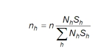
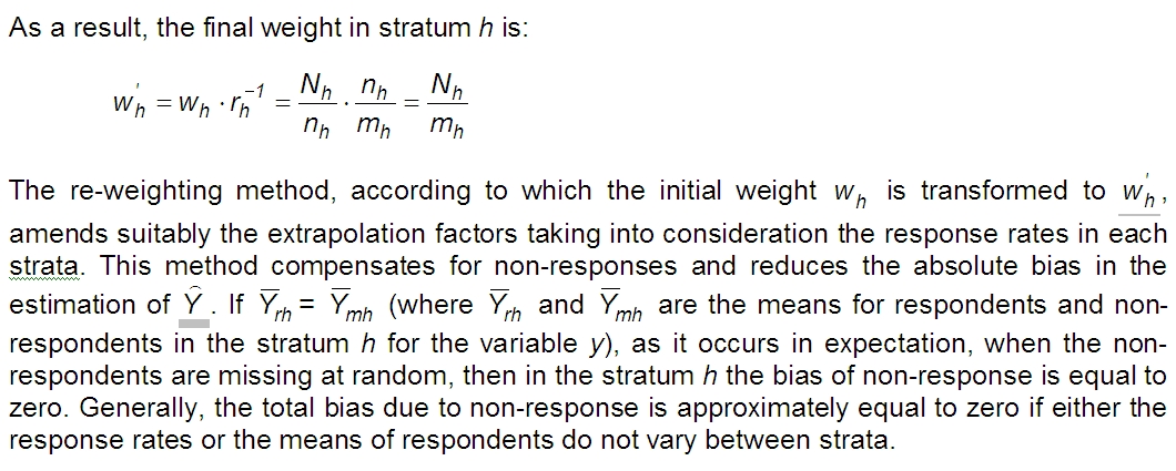
1.      Bellhouse (1988). Systematic sampling. In Handbook of Statistics, Vol. 6, (Eds. P.R. Krishnaiah and C.R. Rao). Amsterdam: Elsevier Science, 125-145   

2.      Cochran, W.G. (1977). Sampling Techniques, New York: John Wiley and Sons

3.      Dalenious T., and Hodges, J.L (1959). Minimum variance stratification. JASA, 54,88-101

4.      Deming, W.E. (1953). On a probability mechanism and the bias of non-response. JASA, 48, 743-772 

5.      Evans, W.D. (1951). On stratification and optimum allocation. JASA, 46, 95-104

6.      Hansen, M.H., Hurwitz, W.N., Madow, W.G. (1953). Sample Survey Methods and Theory. Vol. I, New York: John Wiley and Sons

7.      Hess, I, Sethi, V.K., and Balakrishnan,T.R (1966). Stratification: A practical investigation. JASA, 61, 74-90

8.      Holt, D., and Elliot, D. (1991). Methods of weighting for unit non-response. The Statistician, 40, 333-342

9.      Kalton, G (1983). Models in the Practice of Survey Sampling. International Statistical Review, 51, 175-188  

10.   Kalton, G. and Kasprzyk, D. (1986). The Treatment of Missing Survey Data. Survey Methodology, 12, 1-16.

11.   Kalton, G. and Flores – Gervantes, I. (2003). Weighting Methods. Journal of Official Statistics, 19, 81-97.

12.   Kish, L., (1965). Survey Sampling, New York: John Wiley and Sons

13.   Kish, L., and Frankel, M.R. (1974). Inference from complex samples. Journal of the Royal Statistical Society, A, 139,80-95

14.   Kish, L., and Anderson, D.W. (1978). Multivariate and multipurpose stratification. JASA, 73, 24-34

15.   Kish, L., (1987). Statistical Design and Research, New York: John Wiley and Sons

16.   Kish, L., (1988). Multipurpose Sample Designs. Survey Methodology, 14, 19-32

17.   Kish, L., (1989). Sampling Methods for Agricultural Surveys, Rome: Food and Agricultural Organization of the United Nations

18.   Kish, L., (1992). Weighting for Unequal Pj. Journal of Official Statistics, 8, 183-200

19.   Kish, L (1995).Questions/Answers (1978-1994), Paris: INSEE, International Association of Survey Statisticians 

20.   Little, R.J.A. (1982). Models for non-response in sample surveys. JASA, 77, 237-250

21.   Little, R.J.A. (1986). Survey non-response adjustments for estimates of means. International Statistical Review, 54, 139-157 

22.   Madow, L. H (1946). Systematic sampling and its relation to other sampling designs. JASA, 41, 207-214

23.   Murthy, M.N. and Rao, J.T.(1988). Systematic sampling with illustrative examples. In Handbook of Statistics, Vol. 6, (Eds. P.R. Krishnaiah and C.R. Rao). Amsterdam: Elsevier Science, 147-185

24.   Royall, R.M and Herson, H.J. (1973). Robust Estimation in Finite Populations I.  JASA, 68, 880-889 

25.   Royall, R.M and Herson, H.J. (1973). Robust Estimation in Finite Populations II: Stratification on a Size Variable. JASA, 68, 890-893 

26.   Sarndal, Swensson, and Wretman (1992). Model Assisted Survey Sampling. New York: Springer-Verlag

27.   Thomsen, I. (1977). On the effect of stratification when two stratifying variables are used. JASA, 72, 149-153 

9.7. Quality management - documentation
Quality management - documentation
The following quality reports were made available:

SIMS is the format in which metadata are made available through the ELSTAT web page. It is quite similar to the present NMR (in ESQRS format). The Summary quality report is a 2-page summary of the basic points in the SIMS report.

The NMR is not made directly available to the public through the ELSTAT web page (the SIMS report is provided instead). However, the NMR, after validation, could also be made available after submitting an application to: http://www.statistics.gr/en/provision-of-statistical-data

9.7.1. Metadata completeness - rate

[Not requested]

9.7.2. Metadata - consultations

[Not requested]


10. Cost and Burden Top
Co-ordination with other surveys: burden on respondents
There was no co-ordination with other surveys. 


11. Confidentiality Top
11.1. Confidentiality - policy
Confidentiality - policy
The issues concerning the observance of statistical confidentiality by the Hellenic Statistical Authority (ELSTAT) are arranged by articles 7, 8 and 9 of the Law 3832/2010 as in force, by Articles 8, 10 and 11(2) of the Regulation on Statistical Obligations of the agencies of the Hellenic Statistical System and by Articles 10 and 15 of the Regulation on the Operation and Administration of ELSTAT.

More precisely ELSTAT disseminates the statistics in compliance with the statistical principles of the European Statistics Code of Practice and in particular with the principle of statistical confidentiality: http://www.statistics.gr/en/statistical-confidentiality?inheritRedirect=true

11.2. Confidentiality - data treatment
Confidentiality - data treatment
To ensure adherence to the confidentiality provisions set out in section 11.1 Confidentiality - policy, prior to their publication FSS data are subject to the following procedures:
  • for sample survey data, aggregation of micro-data to a minimum level of NUTS3,
  • primary cell suppression on the aggregated data, using minimum frequency rules, according to the recommendations of the SCC, and
  • secondary cell suppression with full singleton handling.

The above procedures are implemented using the τ-argus software. 


12. Comment Top
1. Possible improvements in the future
Not available.


2. Other annexes
Not available.


Related metadata Top


Annexes Top