European Atlas of the Seas help
About the European Atlas of the Seas, Atlas basics and how to create and share your map
Atlas introduction
The European Atlas of the Seas (hereafter ‘the Atlas’) is an easy to use and interactive web-based geographic application, providing general marine data and maritime information along with statistics on the European seas and coasts. The Atlas catalogue of maps covers various natural and socio-economic aspects and features in the marine and coastal regions of Europe.
The Atlas is a public window to access information and maps based data originating primarily from the EC and its agencies and from the European Marine Observation and Data Network (EMODnet). Its aim is to bring statistical data in a comprehensive visual way to a broad public and at the same time serve as a support for the marine policy and blue economy.
Access the help, legal notice and feedback form
Discover all the data available: you can search for map layers in the search box, select a predefined map or create your own map.
On the map viewer, you can study and compare the data and extract and manage the content details.
Share the map, download the map or share it via social networks.
* The Atlas is available in the 24 official EU languages.
Create and share your map
You can start to create your own map from the homepage pop-up when you first access the Atlas or from the pop-up window that appears when clicking on the magnifying glass icon.
Your map consists of the individual map layers that you have chosen to display in the map viewer. To select or add a map layer to the map viewer, you can either scroll the Atlas catalogue page (a) or search for map layers (b). You can zoom in on a region of interest or a particular location and share (c) your map with friends or colleagues (i.e. Facebook, etc.). You can export your map to print it or to include it in your presentations (d). You also have the possibility to embed your map (e) in a blog or a website.
a) Scroll the Atlas catalogue and add map layers to the map viewer

Click on the tab “Create a map” or “Layers” from the pop-up windows to display the list of maps, which is organised by themes. Explore and select the map layers you want to show on the map viewer.
b) Search and add map layers to the map viewer

Select the map layers by searching them in the search tool. Type one or more characters and the search tool will show you a list of possible map layers which match with the typed text. Click the check box on the left to add the layer to the map viewer.

Close the pop-up window by clicking on the "Close button". The map viewer displays a map with the map layers that you have selected.
Share your map
Click on the “Share” icon to access a pop-up window with different sharing options, divided in three tabs:
- c) Share the access to your map sending an email or share your map on social networks.
- d) Export: generate a pdf document or a jpeg image that you can save or print.
- e) Embed: embed your map in another website by copying the provided code and pasting it in the website html source code.
Atlas catalogue
The data available in the European Atlas of the Seas is spatial marine data classified by different topics or thematic areas (tourism, transport, fisheries, sea bottom…). The catalogue comprises more than 150 map layers and is constantly updated and upgraded.
Predefined maps
The Atlas proposes a collection of predefined maps covering various thematic as EUROPE, NATURE, TOURISM, etc…, which you can also customize to create your own map.
Layer info and get feature info
You can extract and manage the data details at different levels:
 At a layer level: by clicking on the "information” button from the layer widget, you access the content and data defined by the source provider.
- At a feature or element level: by clicking on the map you can see the details of the element or the feature selected (depending on the zoom scale, the result will be one or more elements).

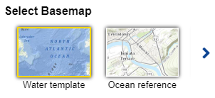
Base map layers
You can change the base map. You find this option at the bottom of the layer widget where different options are available: water template, ocean reference, base template and civil template.

Atlas functionalities
Layers and legends
Expand the layers and legends panel by clicking on the icon. There you can see all the map layers that you have loaded on the map.

By clicking the layer settings icon, you access several parameters attached to each layer:
a slider to adapt the transparency of the layer,
a hide / show layer button,
2 arrows to alternate the order of the layers,
a bin icon to remove the map layer from the map viewer.
By clicking the legend link, you display all legends. All layers have a different symbology to represent its elements.
Zoom in and zoom out
You can perform basic operations on the map:
Zoom in to close in on the map in order to examine a specific area in greater detail.
You can see the initial full geographical extent of the map (or default map view).
Zoom out is the opposite action. You can see a bigger portion of the map with less detail level.
Measurement tool
You can take a measure by drawing on the map. The area or length of the polygon/line drawn is calculated. You can also display the coordinates (latitude and longitude) of a selected point on the map.
Expand the measurement panel and select one of the 3 following operations:

Area

Distance

Coordinates
By clicking on the icon you activate the tool. Click on the map to start measuring.

the flag shows you the spot you selected for your measurement.
Double click to finalize the measurement.

Change the measurements (e.g. from kilometers to miles) by clicking on the dropdown list and the result is automatically recalculated.
Video tutorials
* EU official languages
The European Atlas of the Seas uses translation software powered by EC eTranslation. Translations are provided as a service to users of European Atlas of the Seas, and are provided "as is." No warranty of any kind, either expressed or implied, is made as to the accuracy, reliability, or correctness of any translations made from the source language (English) into any other language. Some content (such as images, feature info, etc.) may not be accurately translated due to the limitations of the translation software.
Copyright © European Union, 1995-2018