Merging statistics and geospatial information, 2014 projects - Hungary
This article forms part of Eurostat’s statistical report on Merging statistics and geospatial information: 2019 edition.
Final report 21 December 2017
Full article
Problem
After successfully identifying and joining the business register to an address register/directory, thereby integrating registers and geodata systems, two further economic registers were chosen for the same treatment — the register of public accommodation establishments and that for non-profit collective accommodation establishments. The Hungarian Central Statistical Office also identified a need to develop an interactive mapping application that could be used to disseminate its most important statistical indicators and their spatial distribution in a harmonised manner.
Objectives
Action 1: continue work on the preparation of the integration of various registers and a geodata-based system through the address register and address directory [1], thereby widening the scope of statistical data that can be merged with geospatial information. The two registers that were the subject of the work were the register of public accommodation establishments and the register of non-profit collective accommodation establishments.
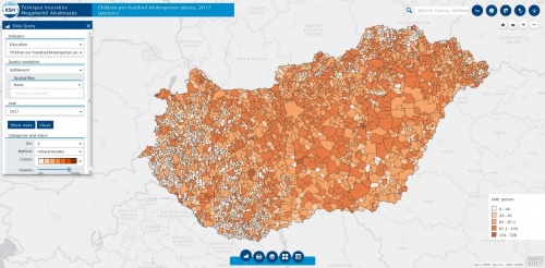
Action 2: ensure public access to geocoded statistical data. The existing interactive mapping application on the statistical office’s website had a number of disadvantages. In order to give more attention to geocoded data (grid-based information), the statistical office committed to develop a new interactive application to give supplementary information to users and offer solutions for user complaints that were identified.
Method
Action 1: addresses for a registry of public and non-profit accommodation establishments (as well as those from some other registers) were stored and managed in a registry of public areas (known as the F054_KÖZTER table).
The first step of the work was to establish a connection between this registry of public areas and an address register and address directory.
An existing address maintenance application was updated. The addresses in the register of public places were checked and corrected automatically by making use of this application. To help the manual checking of questionable addresses a detailed guide was compiled. Possibly erroneous addresses were identified and checked using various alternate address databases, as well as Google maps and other sources of information. Remaining non-identifiable addresses were verified by more than 1 000 local government authorities.
The statistical registers to be linked to geocoded data were prepared for linking by adding new fields and modifying maintenance procedures.
Once the checking of addresses had been completed the registers were connected to the address register and address directory.
Action 2: best practices were identified and studied and a report was compiled for the required functions and services for any new geocoded system. Equally, possible platforms and software were studied and in some cases tested and then a solution was selected: hardware and software were acquired and a new geographic information system (GIS) webserver and operating system were installed. Training for these new information technology (IT) tools was undertaken. The statistical topics and their spatial distribution were defined, alongside other functionalities.
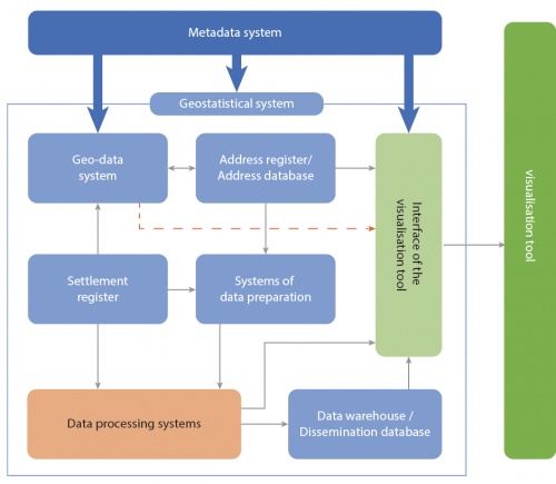
A geostatistical system was planned to set up the conceptual connection between the existing systems and the new interactive application, with the aim of producing detailed spatial data automatically and transmitting these data to different interactive tools. Until such a system is implemented, basic data were compiled manually and data protection (confidentiality treatment) performed.
The functions and performance of an interactive mapping application were tested. A technical description, maintenance documentation and a user manual were compiled.
Results
A register of public accommodation establishments and a register of non-profit collective accommodation establishments were linked to the address register and address directory.
A new interactive mapping application was developed and a geostatistical system was planned.
Direct access to
Methodology
Notes
- ↑ For more information about the address register and address directory see the 2012 project.


