|
 |
| For any question on data and metadata, please contact: Eurostat user support |
|
|||
| 1.1. Contact organisation | CENTRAL STATISTICS OFFICE, IRELAND |
||
| 1.2. Contact organisation unit | Business Statistics Directorate |
||
| 1.5. Contact mail address | Skehard Road, Cork, T12 X00E, Ireland |
||
|
|||
| 2.1. Metadata last certified | 15/06/2023 | ||
| 2.2. Metadata last posted | 15/06/2023 | ||
| 2.3. Metadata last update | 15/06/2023 | ||
|
||||||||||||
| 3.1. Data description | ||||||||||||
Building planning permissions granted in the sector of construction (including civil engineering). |
||||||||||||
| 3.2. Classification system | ||||||||||||
Planning Permissions are classified by type of development (new construction, extension, alteration or conversion), local authority area and by regional authority. A distinction is made between residential and non- residential building and civil engineering. |
||||||||||||
| 3.3. Coverage - sector | ||||||||||||
All local authority areas are covered. The Local Government Act 1991 (Regional Authorities) (Establishment) Order, 1993, which came into operation on 1 January 1994, established eight new Regions. The CSO has adopted these in place of the old Planning Regions as the basis of the regional breakdown of planning permissions data. Regional breakdown of Results NUTS2 and NUTS3 Regions The regional classifications in this release are based on the NUTS (Nomenclature of Territorial Units for Statistics) classification used by Eurostat. The classification was drawn up by Eurostat in order to define territorial units for the production of regional statistics across the European Union. In 2003, the EU Member States, the European Parliament and the Commission established the NUTS regions within a legal framework (Regulation (EC) No 1059/2003). The composition of the regions is set out below:
|
||||||||||||
| 3.4. Statistical concepts and definitions | ||||||||||||
These statistics provide a short-term indicator of the trend in work done in construction in the subsequent quarter. The planning permission data series is governed by the application of The Local Government (Planning and Development) Acts, 1963 to 2000, which impose the requirement that the majority of construction activity obtains planning permission. Each local authority and An Bord Pleanála are required to send details of all planning permissions granted for the period, along with the number of units, a description and floor areas. The number of planning permissions granted, the number of units for which permission is granted and floor areas are aggregated; results are then classified by NUTS2 and NUTS3 regional breakdown, by county, and are also classified by type of development and functional category. Questionnaire (including Explanations) Not applicable as local authorities return all planning permissions granted. No questionnaire is required for this survey. Participation in the Survey Participation is compulsory. |
||||||||||||
| 3.5. Statistical unit | ||||||||||||
Units of Observation/Collection Units/Units of Presentation 31 Local Authorities and An Bord Pleanála send details of all planning permissions granted for the period. An Bord Pleanála is responsible for the determination of appeals and certain other matters under the Planning and Development Acts, 2000 to 2006, and with appeals under the Building Control Act, 1990, the Local Government (Water Pollution) Acts 1977 and 1990 and the Air Pollution Act, 1987. Each Local Authority and An Bord Pleanála provides each individual planning permission. Each permission granted details the planning registration number, the local authority it pertains to, a description of the permission required, the number of units required and the floor area. All variables provided are absolute figures. In each publication, the number of planning permissions granted and units are presented in absolute figures. Total floor area figures, and average floor area per unit is presented in units of 000’s square metres. |
||||||||||||
| 3.6. Statistical population | ||||||||||||
All local authorities in the State and An Bord Pleanála. |
||||||||||||
| 3.7. Reference area | ||||||||||||
Reporting Unit/Respondents Each individual planning application which has been granted is supplied to STS DCU (approximately 5,500 to 7,000 per quarter). The number of planning permissions granted and units are presented in absolute figures. Total floor area figures, and average floor area per unit is presented in square metres. Respondents are all the Local Authorities and An Bord Pleanála. Geographically the data covers the entire Republic of Ireland without exception. |
||||||||||||
| 3.8. Coverage - Time | ||||||||||||
Data first used as a source in 1975 |
||||||||||||
| 3.9. Base period | ||||||||||||
Not relevant as not an index |
||||||||||||
|
|||
In each publication, the number of planning permissions granted and units are presented in absolute figures. Total floor area figures, and average floor area per unit is presented in units of 000’s square metres. |
|||
|
|||
Reference Quarter. |
|||
|
|||
| 6.1. Institutional Mandate - legal acts and other agreements | |||
The procedures whereby information on Planning Permissions is provided to the CSO are governed by the Planning and Development Act, 2000, Section 29. Provides variables 411 and 412 of Annex B (Construction) under the Short Term Statistics Regulation (EC) No 1882/2003 |
|||
| 6.2. Institutional Mandate - data sharing | |||
Section 34 of the 1993 Statistics Act states: The Office may provide, for statistical purposes only, information obtained in any way under this Act or the repealed enactments, in such form that it cannot be directly or indirectly related to an identifiable person or undertaking, to such persons and subject to such charges, conditions and restrictions as the Director General may determine. The data is not sent to the OECD, UN, IMF or other international organisations. |
|||
|
|||
| 7.1. Confidentiality - policy | |||
The provision on statistical confidentiality is regulated by Sections 32 and 33 of the 1993 Statistics Act. Section 32 states: All information furnished by a person, undertaking or public authority under this Act shall be used only for statistical compilation and analysis purposes. Section 33 states: (1) No information obtained in any way under this Act or the repealed enactments which can be related to an identifiable person or undertaking shall, except with the written consent of that person or undertaking or the personal representative or next-of-kin of a deceased person, be disseminated, shown or communicated to any person or body except as follows: (a) for the purposes of a prosecution for an offence under this Act; (b) to officers of statistics in the course of their duties under this Act; (c) for the purposes of recording such information solely for the use of the Office in such form and manner as is provided for by a contract in writing made by the Director General which protects its confidentiality to his satisfaction (2) The Office may, for statistical purposes only, assign codes derived from information collected under this Act classifying undertakings listed in the administrative systems of other public authorities by economic activity and size (persons engaged) categories. (3) The Taoiseach may by order prescribe such further prohibitions on the disclosure of identifiable records or information obtained under this Act or the repealed enactments for such periods as may be prescribed. (4) Nothing in this Act shall be construed to require any person or undertaking to provide information in relation to a matter on which information was sought in circumstances that would entitle the person or undertaking to decline to give the information in a civil proceeding in any court or on grounds of privilege. |
|||
| 7.2. Confidentiality - data treatment | |||
All data collected is treated as confidential. |
|||
|
|||
| 8.1. Release calendar | |||
A four month advance release calendar is published on the CSO website. |
|||
| 8.2. Release calendar access | |||
| 8.3. Release policy - user access | |||
Simultaneous release to all interested parties: No users have prior access to the data before its general release. Data are made available to all users simultaneously on predefined days on the CSO website home page : http://www.cso.ie/en/index.html Transmission to Eurostat: Data are transmitted on the same day as the national publication within 80 days of the reference period. The transmission is done via eDamis. |
|||
|
|||
Quarterly: both to Eurostat and nationally |
|||
|
|||
| 10.1. Dissemination format - News release | |||
News releases for planning permissions are not produced on a regular basis. An infographic is published alongside the 4th quarter and yearly summary release, along with a press release. |
|||
| 10.2. Dissemination format - Publications | |||
Data on production in construction are released in the following locations on the CSO website: "Statistics" "Business Sectors" "Construction" “Releases and Publications" - “Current Releases” on the CSO homepage http://www.cso.ie/en/index.html and also on https://www.cso.ie/en/statistics/buildingandconstruction/ The quality description of the statistics, as well as concepts and definitions, are available on http://www.cso.ie/en/surveysandmethodology/construction/planningpermissions/ |
|||
| 10.3. Dissemination format - online database | |||
The Planning Permissions tables released in the online database PxStat on the CSO website are updated quarterly: |
|||
| 10.4. Dissemination format - microdata access | |||
Microdata is not publicly available. |
|||
| 10.5. Dissemination format - other | |||
Data are sent to Eurostat to be used in European aggregates and/or to be released as national data. |
|||
| 10.6. Documentation on methodology | |||
Dissemination of documentation on methodology and sources used in preparing statistics: This is available on the internet at: http://www.cso.ie/en/methods/construction/planningpermissions/ |
|||
| 10.7. Quality management - documentation | |||
This is available on the internet at: http://www.cso.ie/en/methods/construction/planningpermissions/ |
|||
|
|||
| 11.1. Quality assurance | |||
Each planning permission granted is manually coded to type of permission (i.e. new development, extension, alteration and renovation or conversion) and to category of construction. The number of units and floor area are also coded where applicable. Imputation (for Non-Response or Incomplete Data Sets) None Grossing and Weighting Not applicable. Computation of Outputs Planning permissions are presented by NUTS2 and NUTS3 regional breakdown, and then classified by county, type of development (new construction, extension, alteration or conversion), local authority district and by regional authority. Total floor areas for planning permissions granted are also given. Other Quality Assurance Techniques Used Staff training. Staff meet with key people in local authorities and An Bord Pleanála to discuss any quality issues and to clarify permissions reporting. The quality system used within the CSO is detailed in a corporate document entitled "Standards and Guidelines, Volume 1, Quality in Statistics". |
|||
| 11.2. Quality management - assessment | |||
Planning Permissions are based on administrative data. Publication of results are always punctual. Further methodological details and other information can be found in point 13. Accuracy. Planning Permissions data is checked for consistency with other data sources such as:
The planning permissions predict the trend in work done by one quarter and the trends between series are consistent on a quarterly basis regarding numbers employed and hours worked. As a result, there are no obvious weak points. |
|||
|
|||
| 12.1. Relevance - User Needs | |||
Planning Permissions are a reliable indicator of activity in the construction sector, and is required as a short term indicator by the EU. but while it provides good estimates of quarter-on- quarter change, it is not designed to be used to examine long term or structural changes in the construction sector. It is of relevance to the following user groups:-
|
|||
| 12.2. Relevance - User Satisfaction | |||
No index for user satisfaction is available, but there are regular meetings with national experts and essential users to meet new requirements, if these are not in conflict with legal necessities or constraints. In addition a user’s satisfaction survey takes place at periodic intervals. |
|||
| 12.3. Completeness | |||
Planning permissions are fully compliant under the Short Term Statistics Regulation (EC) No 1882/2003. |
|||
|
|||
| 13.1. Accuracy - overall | |||
This series is a reliable indicator of activity in the construction sector. The planning permissions reliably predict the trend in work done by one quarter and the trends are consistent on a quarterly basis regarding numbers employed and hours worked. As a result, there are no obvious weak points. |
|||
| 13.2. Sampling error | |||
None – all areas in the State are covered. |
|||
| 13.3. Non-sampling error | |||
Quality of the Data Sources Used In general, the data provided by the Local Authorities and An Bord Pleanála is suitable for use by the section. It is sufficiently detailed so that the data can be coded by STS DCU in a consistent manner on a monthly basis. Data is manually coded by the section based on the information given in the template. Monthly data is compiled into quarterly data. All planning permissions are given a unique identifier using a combination of elements that constitute a planning permission, i.e. using the type of permission, category of construction, the planning authority it pertains to and the Planning Registration Number. The template used by most Local Authorities is generally the same, which means the structure of the data is consistent over time and the data is therefore comparable with previous periods. The system used does not allow for entry of duplicate records. A number of edits are run on the data each month to check for inconsistencies or invalid entries. Any errors or inconsistencies are corrected. Register Coverage All local authority areas are covered. The Local Government Act 1991 (Regional Authorities) (Establishment) Order, 1993, which came into operation on 1 January, 1994, established eight new Regions. The CSO has adopted these in place of the old Planning Regions as the basis of the regional breakdown of planning permissions data. Non-Response (Unit and Item) Not relevant - data is always received from each local authority. Measurement Errors Measurement errors are not formally calculated; however the following measures have been put in place: Each return is checked and the relevant Local Authority is contacted if necessary. Also there is comprehensive inter - staff checking, following manual coding of data. It is then checked against a summary form lodged with the copy of permissions from each local authority. Some training has been provided to relevant personnel in the local authorities and An Bord Pleanála. Finally, normal system edit checks uncover most errors. Processing Errors Any errors that arise are checked and rectified each month. All data received from a Local Authority is manually coded and then scanned. If characters are rejected by the scanner, they are keyed manually. All characters keyed are numeric. Those coding the data enter the data clearly so as to minimise scanning errors. Edits are then run on the data following scanning to highlight any errors. A combination of range and consistency checks are performed on the data. Edits are then re-run after any corrections are made. Model-related Effects Not relevant as all data is received from each local authority. |
|||
|
|||
| 14.1. Timeliness | |||
This series is published within 80 days of the reference date. |
|||
| 14.2. Punctuality | |||
National publication always on time. Deliveries to Eurostat have also always been sent well in advance of the regulation deadline apart from Q4 2015 when it was on time. |
|||
|
|||
| 15.1. Comparability - geographical | |||
It is possible to compare calculated Irish aggregates with those of other European countries, due to harmonised STS indices in the European Union. |
|||
| 15.2. Comparability - over time | |||
Comparisons are made between quarters going back to 2000 and there is no break in the time series. |
|||
| 15.3. Coherence - cross domain | |||
While planning permission data only shows planning permissions granted, these figures can be compared with the publication produced by the Department of Housing, Planning, Community and Local Government publication on housing statistics (which includes house commencements and completions). When compared, these series give some indications of trends in the construction sector.
(a) House completions data series are based on the number of new dwellings connected by ESB Networks to the electricity supply. These represent the number of homes completed and available, and do not reflect any work-in progress. (b) House commencements: The unusually high figures for February 2014 arose from the introduction on March 1st of the new Building Control (Amendment) Regulations 2014 (S.I. No. 9 of 2014). The trigger for the application of the new regulations is the lodgement of a commencement notice application. In order to avoid the additional obligations under the new regulations, many projects may have been fast-tracked and commencement notice applications lodged prior to the coming into effect of the new regulations on 1 March 2014. (c) House registrations: Data up to and including 2001 and from 2010 represent HomeBond Registrations. Data from 2002 to 2009 includes HomeBond Registrations and Premier Guarantee Registrations. |
|||
| 15.4. Coherence - internal | |||
Planning Permissions are a reliable indicator of activity in the construction sector. The planning permissions reliably predict the trend in work done in construction by one quarter and the trends are consistent on a quarterly basis regarding numbers employed and hours worked. As a result, there are no obvious weak points.
An analysis quantifying the differences between the above is not published but one reason is that each data series serves a different purpose. An internal coherence exercise is undertaken on a quarterly basis as follows: (a) LFS: when the numbers employed in construction rise or fall one would expect the volume of construction to similarly rise or fall. (b) EHECS: when the number of hours worked in construction rise or fall one would expect the volume of construction to similarly rise or fall. (c) Comparing trends of planning permissions by product (residential, civil engineering and non residential) planning permissions predict the trend of the production in construction by one quarter. |
|||
|
|||
The STS division continues to undergo Lean Six Sigma reviews addressing both cost and burden |
|||
|
|||
| 17.1. Data revision - policy | |||
This revision policy is described in footnotes given for the relevant tables and in the description of the respective statistics. There is at least one quarter advance notice given for major changes in methodology by including footnotes in the respective tables. We also have a database called PxStat, which contains all published Planning permissions data, and it has an audit trail of all revisions going back since the survey was first introduced. Any revisions made nationally are transmitted to Eurostat at the same time. |
|||
| 17.2. Data revision - practice | |||
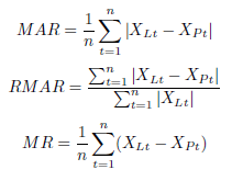
Planning Permissions data is typically not revised as we do not publish until we receive data from each local authority. However a revision was made in 2015 due to an exceptional planning process. Also, a new planning application process called Strategic Housing Development (SHD) applications were introduced in 2018. These led to some revisions of the Q1 2018 data in Q2 2018 and again in Q3 2018. The Strategic Housing Development (SHD) process expired on 25 February 2022. Its successor, the Large-Scale Residential Development (LRD) scheme came into effect on 17 December 2021. Currently revisions due to SHD or LRD applications are made at the time of the Q4 release each year. The Quality Indicators used in the data revision practice are: MAR (Mean Absolute Revision) and MR (Mean Revision). The formulas used to calculate these QI are:
The computed values for the last 20 quarterly Building Permits indicators are:
|
|||
|
|||
| 18.1. Source data | |||
All local authorities in the State and An Bord Pleanála. |
|||
| 18.2. Frequency of data collection | |||
Data are collected on a monthly basis. |
|||
| 18.3. Data collection | |||
Each local authority returns their summary of planning permissions granted and each planning application with floor area, by e-mail or by post. Information is not collected on floor areas for alterations and conversions. Emails and telephone calls are used to seek the prompt return of administrative data. |
|||
| 18.4. Data validation | |||
Each return is scrutinized for errors or missing data and for any discrepancy between the stated planning permissions granted and the numbers of planning applications returned. Any queries are followed up with the relevant local authority. The data received is coded by the section, scanned and verified, and then imported into the CSO Data Management System (DMS). A number of validation procedures are in place for all returned data:
If differences exceed specified thresholds, an edit is raised. The system produces lists of errors for each type of edit each quarter. These are then analysed and records are corrected as appropriate. In addition box plots compare values for variables in each category of work done against previous returns. SDMX is the tool currently used in validating the structure of the file and codes used that is submitted to Eurostat. The data itself is copied from the publication. SDMX replaced GESMES from the transmission of Q1 2019 data in June 2019. |
|||
| 18.5. Data compilation | |||
Planning permissions are presented by NUTS2 and NUTS3 regional breakdown, and then classified by county, type of development (new construction, extension, alteration or conversion), local authority district and by regional authority. Total floor areas for planning permissions granted are also given. |
|||
| 18.6. Adjustment | |||
The data series is unadjusted |
|||
|
|||
| Restricted from publication | |||
|
|||
|
|||