Land prices and rents (apri_lpr)

National Reference Metadata in Euro SDMX Metadata Structure (ESMSAL)

Compiling agency: Ministry of Agriculture, Fisheries and Food


Eurostat metadata
Reference metadata
1. Contact
2. Metadata update
3. Statistical presentation
4. Unit of measure
5. Reference Period
6. Institutional Mandate
7. Confidentiality
8. Release policy
9. Frequency of dissemination
10. Accessibility and clarity
11. Quality management
12. Relevance
13. Accuracy
14. Timeliness and punctuality
15. Coherence and comparability
16. Cost and Burden
17. Data revision
18. Statistical processing
19. Comment
Related Metadata
Annexes (including footnotes)


For any question on data and metadata, please contact: Eurostat user support

Download


1. Contact Top
1.1. Contact organisation

Ministry of Agriculture, Fisheries and Food

1.2. Contact organisation unit

Ministry of Agriculture, Fisheries and Food

Department of Analysis, Coordination and Statistics

Telephone: +34 913475403

e-mail address: sgapc@mapama.es

1.5. Contact mail address

Paseo Infanta Isabel, Nº 1

28071 Madrid-SPAIN-


2. Metadata update Top
2.1. Metadata last certified 30/12/2020
2.2. Metadata last posted 30/12/2020
2.3. Metadata last update 30/12/2020


3. Statistical presentation Top
3.1. Data description
  Land prices  Land rents 
Data description

Land price represents the purchase price of an hectare of land for agrarian usage. The amount of money received by the owner (or paid by the buyer) in free commerce, in the reference period (calendar year)

Since 1983, the Ministry of Agriculture, Fisheries and Food, through the Statistical Unit, has been publishing annual results on land prices and national and regional indices.

The fundamental objective is to measure the annual changes in the price level of the most significant land classes, free for sale and intended for agricultural use.

The aggregations, functional and geographic, of the average land prices require identifying classes for the most representative crops based on the existing crop categories, as well as the weighting structure of those categories. The classes (arable land and permanent grassland) and stuctures are adapted to the changes in economic environment through changing basis, 2016 (based upon Farm Structure Survey) being the reference year for the current basis.

This survey is important because of its various uses, e.g. as a reference in operations related to purchase-sale transactions, valuations for expropriations, taxes, etc.

Regarding the territorial classification of the data collection, in Spain the land prices and land rents are provided to the national statistical unit by provinces, this is NUTS 3. Subsequently, these are integrated at the autonomous community level, this it is NUTS 2. Later, they are integrated by groups of autonomous communities that form specific geographic zones, this is NUTS 1. Finally, the geographical zones are integrated at the national level, this is NUTS 0.

The agricultural land rent represents the price of renting one hectare of agricultural land in the reference period (calendar year). The renting prices should be collected from the person renting the agricultural land for agricultural use (renting price paid).

The Ministry of Agriculture, Fisheries and Food, considered it necessary to prepare a specific survey that would reflect the value and evolution of the rents for the most significant land classes and the different Autonomous Communities; as a result, this survey has been developed since 1998 jointly by both administrations.

The classes (arable land and permanent grassland) and stuctures are adapted to the changes in economic environment through changing basis, 2016 (based upon Farm Structure Survey) being the reference year for the current basis.

This survey was especially important as a result of the entry into force of the "Law of Rural Rents" approved on November 26, 2003.

Regarding the territorial classification of the data collection, in Spain the land prices and land rents are provided to the national statistical unit by provinces , this is NUTS 3 . Subsequently, these are integrated at the autonomous community level, this it is NUTS 2. Later, they are integrated by groups of autonomous communities that form specific geographic zones , this is NUTS 1. Finally, the geographical zones are integrated at the national level, this is NUTS 0.

The land prices and land rents for a given year are collected in December of the reference year of the data. This is done by the autonomous communities which send them to the national statistical unit in the first semester of the year following the reference year of the data.

3.2. Classification system
  Land prices  Land rents 
Classification system

Spain

Noroeste

Galicia

Asturias

Cantabria

Noreste

País Vasco

Navarra

La Rioja

Aragón

Madrid

Centro

Castilla y León

Castilla-La Mancha

Extremadura

Este

Cataluña

Comunidad Valenciana

Illes Balears

Sur

Andalucía

Murcia

Ceuta

Melilla

Canarias

Spain

Noroeste

Galicia

Asturias

Cantabria

Noreste

País Vasco

Navarra

La Rioja

Aragón

Madrid

Centro

Castilla y León

Castilla-La Mancha

Extremadura

Este

Cataluña

Comunidad Valenciana

Illes Balears

Sur

Andalucía

Murcia

Ceuta

Melilla

Canarias

3.3. Coverage - sector
  Land prices  Land rents 
Coverage - sector

In Spain, the economic sectors covered by land prices and land rents are (NACE- 2009):

01 Agriculture, livestock, hunting and related services

0111, 0112, 0113, 0114, 0115, 0116, 0119, 0121, 0122, 0123, 0124, 0125, 0126, 0128, 0129 and 0130.

In Spain, the economic sectors covered by land prices and land rents are (NACE- 2009):

01 Agriculture, livestock, hunting and related services

0111, 0112, 0113, 0114, 0115, 0116, 0119, 0121, 0122, 0123, 0124, 0125, 0126, 0128, 0129 and 0130.

3.4. Statistical concepts and definitions

Definition of the land price values

  Land prices  Land rents 
Definition of the land price values

In practice, this means: the actual price agreed upon by the agents participating in each transaction.

Land rents price is defined as the payment that a farmer makes to an owner of Land for the use of it.

The costs of transferring ownership (therefore lawyer's fees, registration taxes and real estate) are excluded from collected selling/purchase price of agricultural land? Yes Not applicable. 
The value of deductible VAT is excluded from the price of agricultural land? Yes Yes
The entitlements related to the land are excluded from the collected selling/purchase/renting price of agricultural land? Yes Yes
The value of any buildings or dwellings situated on it and any other expenses related to other assets except the agricultural land (current maintenance expenditure on buildings, buildings insurance, depreciation of buildings, rents paid for the professional use of non-residential buildings etc.) are excluded from the price of agricultural land? Yes Yes
The value of any monetary compensation received by farmers for the sales/acquisition of the Utilized Agricultural Area is excluded from the collected selling/purchase price of agricultural land? Yes Not applicable. 
The value of any inheritances transfers related to the sold/purchased land is excluded from the collected selling/purchase price of agricultural land? Yes Not applicable. 
If you have replied NO to any of the above questions explain the reason why. 

Not applicable.

Not applicable.


EU Target Methodology

  Land prices  Land rents 
Does the data collection observe the land categories as specified in the EU Target Methodology?  Yes Yes
If not, please describe the differences. 

Not relevant.

Not relevant.


Other UAA categories

  Land prices  Land rents 
Does the price information provided to Eurostat include information on other UAA categories?  Yes Yes
If yes, specify which categories. 


The types of crops and permanent grassland are: cereal, rice, dried pulses, root crops, industrial crops, green fodder from arable land, flowers and ornamental plants, seeds, other field products (non-irrigable / irrigable), irrigated fresh vegetables, irrigated crops under glass, rice, irrigable citrus fruits, fruit trees from temperate climates (non-irrigable / irrigable), nuts (irrigable / non-irrigable), fruit trees from subtropical climates (non-irrigable / irrigable), vineyard (for table use / for wine use) (non-irrigable / irrigable), olive (for table use / for oil use ) (non-irrigable / irrigable), permanent grassland (non-irrigable / irrigable). These categories (from the Farm Structure Survey 2016) are compatible, both in definition and in aggregation with those required by the harmonized methodology proposed by the EUROSTAT.

The classes of crops and permanent grassland are: cereal, rice, dried pulses, root crops, industrial crops, green fodder from arable land, flowers and ornamental plants, seeds, other field products (non-irrigable / irrigable), non-irrigable vineyard, non-irrigable olive tree, and permanent grassland. These categories (from the Farm Structure Survey 2016) are compatible both in definition and aggregation with those required by the harmonized methodology proposed by the EUROSTAT.

3.5. Statistical unit
  Land prices  Land rents 
Reporting unit 

The sources of information used by these entities can be: property registers, agents from the real estate agencies at the regional level, county agricultural services, agricultural chambers, agrarian unions, banks or savings banks, direct information from farmers, farm brokers and administrative data, local representations of the Ministry of Agriculture, agricultural advisory services; depending on the availability of information in each Autonomous Community and its provinces.

These questionnaires are treated statistically by the Autonomous Communities and sent to the General Subdirectorate of Statistics of the Ministry that is responsible for the calculation of the rents and indices, for the classes and geographical disaggregations already referred.

Observation unit 

The main variable to be calculated is the weighted average price of the land occupied by each crop and permanent grassland, expressed in euro / hectare, for the reference period (calendar year).

The fundamental variable object of calculation is the weighted average rent of types of the crops and permanent grassland, expressed in euro / hectare, for the reference period (calendar year).

3.6. Statistical population
  Land prices  Land rents 
Does any kind of physical, economical or other threshold apply for data collection on land prices and rents? 

There is no threshold regarding the area of the different types of crops. All those that belong in the utilized agricultural area and appear in the Farm Structure Survey (2016) are included in the survey.

There is no threshold regarding the area of the different types of crops. All those that belong in the utilized agricultural area that appear in the Farm Structure Survey (2016) are included in the survey.

Crops that amount to less than 5% of the utilized agricultural area are not included in the survey.

3.7. Reference area
  Land prices  Land rents 
Reference area

The National territory with exclusion: Ceuta and Mellla autonomous cities.

For each type of crop and permanent grassland, provinces are selected according to the following criteria: they are ordered from highest to lowest by occupied area, selecting those that together represent 80% of the total area for each type. In addition, those provinces considered of special interest by the Autonomous Communities are included.

The National territory with exception: Ceuta and Melilla.

Types of land that are the most significant according to the information provided by surveys carried out by the Autonomous Communities, and represent at least 80% of the leased area in each province.

3.8. Coverage - Time
  Land prices Land rents
Time coverage 

Since 1983 to 2019.

Since 1998 to 2019.

When was the first survey/data collection on land prices and rents in line with common Target Methodology organised? 

Since 2016 to 2019.

Since 2016 to 2019.

3.9. Base period

For land prices and rents, year 2016 according Farm Structure Survey FSS


4. Unit of measure Top
  Land prices  Land rents 
Is the price provided in national currency?  Yes Yes
Is the data on area provided in hectares?  Yes Yes


5. Reference Period Top
  Land prices Land rents
Is the reference period used for rental price the calendar year?  Not applicable.  Yes
If not, specify the reference period used Not applicable. 

Not applicable


6. Institutional Mandate Top
6.1. Institutional Mandate - legal acts and other agreements
  Land prices Land rents
Legal acts and other agreements 

This is a statistical operation whose execution is mandatory because it is included in the operations of the "National Statistical Plan".

This is a statistical operation whose execution is mandatory because it is included in the operations of the "National Statistical Plan".

This survey was especially important as a result of the entry into force of the "Law of Rural Rents" approved on November 26, 2003.

6.2. Institutional Mandate - data sharing

The sharing of data among the statistics institutions at the national level (National Institute of Statistics, ministry departments, autonomous and public entities of the State), as well as between them and the statistics services of the Autonomous Communitites for the development of the statistics entrusted to them, are regulated with the Law of Public Statistical Function. This law also establishes the statistic coordination mechanisms between administrations, as well as the agreements of colaboration when needed.

The statistics services of the Autonomous Communities are responsible for collecting the prices of the representative classes at the levels of region, agricultural district and municipalities-sites selected.


7. Confidentiality Top
7.1. Confidentiality - policy

The Law 12/1989 of Public Statistical Function establishes that the Ministry of Agriculture, Fisheries and Food cannot disseminate, or make available in any way, individual or aggregate data that could lead to the identification of information previously unknown to a person or entity.

7.2. Confidentiality - data treatment
  Land prices Land rents
Confidentiality - data treatment 

All personnel that participate in the various tasks of this investigation are responsible for upkeeping the confidentiality of the obtained data.

Necessary logical, physical and administrative measures are adopted so that the protection of confidential data is effective, since the data collection until its publication and storage.

In the survey questionnaires a legal clause is included to inform of the ways the collected data are protected.

Once the stages of collecting and treating the information are finished, the physical questionnaires that allow direct identification are kept during the legally established period in a safe place. After the period is over, they are destroyed.

Upon publication of the tables of results, the information detail is analyzed to prevent deduction of confidential data from the statistics units.


8. Release policy Top
8.1. Release calendar

The release calendar is released once the National Statistics Plan program is approved. Both these statistical operations are released on a yearly basis.

8.2. Release calendar access

The release calendar is released in the website of the Ministry of Agriculture, Fisheries and Food.

8.3. Release policy - user access

The data are published in the website of the Ministry of Agriculture, Fisheries and Food according to the established release calendar. The releasing of the data is also announced whenever it takes place in the section of latest statistical news of the website.

Before release, the Autonomous Communities have access to the final results and publication.

Users may receive information upon request, as it is specified in the European Statistics Code of Practice.


9. Frequency of dissemination Top

Annual


10. Accessibility and clarity Top
10.1. Dissemination format - News release

The press bureau of the Ministry of Agriculture, Fisheries and Food organizes press releases announcing the dissemination of the data from these statistical operations.

10.2. Dissemination format - Publications

The electronic release takes place in the specific section of the website of the Ministry of Agriculture, Fisheries and Food for each statistical operation.

Additionally, data of the operations is published in the Monthly Statistics Newsletter and the Yearbook of Agricultural Statistics.


Annexes:
Monthly Statistics Newsletter (August-September 2020)
Land Rents section of the website of the Ministry of Agriculture, Fisheries and Food
Yearbook of Agricultural Statistics
Land Prices section of the website of the Ministry of Agriculture, Fisheries and Food
10.3. Dissemination format - online database

Results in database format are not released.

10.4. Dissemination format - microdata access

The safekeeping and anonymization of the microdata is carried out by the Autonomous Communities, whom are responsible of collecting the information according to the arranged Colaboration Agreements.

10.5. Dissemination format - other

The final results of each statistical operation are available as charts in Excel format on the website of the Ministry of Agriculture, Fisheries and Food. These charts showcase the results aggregated by crops, Autonomous Communities and at the national level.

10.6. Documentation on methodology

The detailed description of the methodology and concepts related to the statistical operations is available on the website of the Ministry of Agriculture, Fisheries and Food.


Annexes:
Land Prices Methodology
Land Rents Methodology
10.7. Quality management - documentation

Documentation on the quality management of the data in this statistical operations is not available.


11. Quality management Top
11.1. Quality assurance

The statistics of the Ministry of Agriculture, Fisheries and Food follow guidelines to assure the quality and credibility of the data. Said guidelines are listed in the European Statistics Code of Practice and treat, among other aspects, professional independence, confidentiality protection, reliability of results, precission, punctuality, accessibility, clarity, comparability and coherence.

11.2. Quality management - assessment

The sampling plan is intended to minimize sampling errors, and the various processes of the survey are aimed at supressing or reducing mistakes as much as possible, both at the collecting and the processing stage.

As for the survey limitations, they are those inherent to the statistical operations by sampling. In any case, they are contained within reasonable limits.

This concept is one of the fundamental challenges of the survey, taking into account that at times there is a low quantity of purchase operations.


12. Relevance Top
12.1. Relevance - User Needs
  Land prices Land rents
Are the data on land prices and rents collected for national purposes (by NSI or any other national administration) in your country? 

Yes

Yes

Are there any differences between the current EU Target Methodology and the national methodology?  No No
If yes, please describe the differences. 

Not applicable.

Not applicable.

12.2. Relevance - User Satisfaction

There are no studies or specific surveys about user satisfaction, although there does exist a great demand of the results of these operations.

12.3. Completeness

This statistic operations satisfy the requirements established by the National Statistics Plan.


13. Accuracy Top
13.1. Accuracy - overall

The sample size of the Land Prices and Rents surveys allows us to offer average prices of the most significant agrarian land within reasonable sampling errors.

In each region those agricultural districts that, after being sorted from bigger to smaller area, take up at least 80% of the area occupied by the crop type of interest in said region.

13.2. Sampling error

Sampling errors are not calculated, taking into account the number of purchase operations. The agricultural districts and sites of reference used are always the same.

13.3. Non-sampling error

A control of non-sampling errors is carried out throughout all the statistic process.

The regional services of the Autonomous Communities, within their scope, select expert technicians that are familiar with the land arket and fill in the questionnaires following specific calendar and instructions. The data collecting, at the beggining, is useful to analyze potential errors in the filling in of questionnaires, and to solve said problems in the subsequent field trips of the surveyors.

In the field, maximum, minimum and most frequent values are annotated. The land price to consider is the most representative for a specific location, as long as it refers to free land for sale and whose purpose is agrarian usage.

The collected data are refined by correcting potential inconsistencies. Once they are received and stored, there is another review to find potential deviation of values overall and insonsistencies are corrected.


14. Timeliness and punctuality Top
14.1. Timeliness
  Land prices Land rents
Timeliness 

Nine months

Twelve months

When were data first released to the public? 

The data from the year "n" (base 2016) are released in September of the year "n+1"

The data from the year "n" (base 2016) are released in December of the year "n+1"

14.2. Punctuality

There is no time lag.


15. Coherence and comparability Top
15.1. Comparability - geographical
  Land prices Land rents
Comparability - geographical (regional) 

Comparability of results between the various Autonomous Communities is assured by the existence of a common methodology, design and process of data collection, refinement, edition and aggregation for all the geographic area.

Comparability of results between the various Autonomous Communities is assured by the existence of a common methodology, design and process of data collection, refinement, edition and aggregation for all the geographic area.

15.2. Comparability - over time
  Land prices Land rents
Comparability - over time 

The data delivered to EUROSTAT 2016 through 2019 (base 2016) are comparable over time.

The data delivered to EUROSTAT 2016 through 2019 (base 2016) are comparable over time.

15.3. Coherence - cross domain

There are no other information sources on the Land Price and Rents.

15.4. Coherence - internal

The internal coherence of the statistics is consequence of the application of the same methodologic criteria and an analysis of potential inconsistencies between the various variables.


16. Cost and Burden Top

The complex nature of the questionnaires represents a sizeable burden to the informants. This burden may be alleviated it the expert technicians turn to institutions that collaborate with data in order to fill in the questionnaires.


17. Data revision Top
17.1. Data revision - policy

There is no dissemination of updates, only definitive results.

17.2. Data revision - practice

There is no data revision in practice, since updates and provisional results are not released, only definitive ones.


18. Statistical processing Top
18.1. Source data
  Land prices Land rents
Source data 

The statistical data can be collected by means (depending on the Autonomous Communities system) of:

1. Direct observation of land prices.

2. Statistical data collection via a network of experts, "experts estimates".

3. Use of administrative data.

The statistical data can be collected by means (depending on the Autonomous Commmunities system) of:

1. Direct observation of land rents.

2. Statistical data collection via a network of experts "experts estimates".

3. Use of administrative data.

18.2. Frequency of data collection
  Land prices Land rents
Are the data collected on the regular, annual, basis?  Yes Yes
If yes, since when? If not, what is the frequency of data collection? 

Since 1983.

Since 1998.

18.3. Data collection
  Land prices Land rents
Primary data collection method 

"Ad hoc" questionnaire

"Ad hoc" questionnaire

18.4. Data validation
  Land prices Land rents
Data validation 

By calculating averages and removing outliers that are suspected of refering to non-agrarian usage.

By calculating averages and removing outliers that are suspected of refering to non-agrarian usage.

18.5. Data compilation
  Land prices Land rents
Data compilation process 

The aggregations of functional average prices, both by crop type and geographical, are calculated by weighting the elementary prices by the area allocated in the base. The calculated weights remain fixed throughout the period of validity of the base.

The average price of group "k" is mathematically expressed as follows:

where:

N = number of crop classes that make up group "k"

Wi = weighting per unit of increase of the area of crop "i" in group "k"

PMi = average price per hectare of crop "i"

This formula is applied in each of the geographical levels where average prices are calculated, i.e. Autonomous Communities and country.

To calculate the average price of a class in a province, the representativeness of each class in lower geographical levels must be taken into account:

1. Selection of agricultural districts: the reference territorial unit is the agricultural district, and in each province those whose occupied surface amounts to at least 80% of the regional area of the specific class, after being sorted from lower to higher, are selected. However, and according to criteria set by Autonomous Communities, agricultural districts that do not fulfill the previous requirement may be included if they are of special interest.

2. Selection of municipalities-sites: elementary units subject to surveys have been established within the agricultural districts, i.e. municipalities or sites. A site is defined as  a geographical area that is homogeneous from the land price standpoint. This criteria is likewise applied for the selection.


Weightings

The weighting of a crop "i" for the calculation of the price is obtained as a quotient between the average area occupied by said crop during the reference period and the effective Utilized Agricultural Area (UAA): 

Wi = Effective area of ​​the crop "i" / Effective UAA

The weights remain fixed throughout the period of validity of the base change made.

The same crop may have different weights in the different geographical groupings, according to the superficial importance in each of these sets.

The functional aggregation of rents, both geographically and by crop types, is carried out by weighting the elementary rents by the assigned area in the base. These basic rents are those of each type of crop in the different provinces and are expressed in euros per hectare. The calculated weights remain fixed throughout the validity period of the base.

The average rent of group "k" is mathematically expressed as follows:

where:

N = number of crop classes that make up group "k"

Wi = weighting per unit of increase of the area of crop "i" in group "k"

PMi = average price per hectare of crop "i"

This formula is applied in each of the geographical levels where average prices are calculated, i.e. Autonomous Communities and country.

To calculate the average price of a class in a province, the representativeness of each class in lower geographical levels must be taken into account:

1. Selection of agricultural districts: the reference territorial unit is the agricultural district, and in each province those whose occupied surface amounts to at least 80% of the regional area of the specific class, after being sorted from lower to higher, are selected. However, and according to criteria set by Autonomous Communities, agricultural districts that do not fulfill the previous requirement may be included if they are of special interest.

2. Selection of municipalities-sites: elementary units subject to surveys have been established within the agricultural districts, i.e. municipalities or sites. A site is defined as a geographical area that is homogeneous from the land price standpoint. This criteria is likewise applied for the selection.


Weightings

The weighting of a crop "i" for the calculation of the rent is obtained as a quotient between the surface leased in the geographical reference group "k" occupied by said crop and the total leased area of ​​the crop:

Wi = Leased surface of the crop "i" / Effective UAA

The weights remain fixed throughout the period of validity of the base change made.

The same crop may have different weights in the different geographical groupings, according to the superficial importance in each of these sets.

Is the aggregation at country level carried out in accordance with the EU Target Methodology?  Yes Yes
How the aggregation at country level is carried out? 

Formula used to calculate prices

The general average prices in the year "T", from geographical or functional groups (both current and constant prices), are calculated with the following formula:

where:

N = number of geographical groupings or crop classes-uses that make up the national total.

Wi = superficial weighting, as much as one, of the geographical grouping or classes of crops-uses that make up the national total.

= average price in year "T" of the referred geographic group or type of crop-use "i".

The Statistical Units of the Autonomous Communities are responsible for collecting the prices of the representative classes in the selected municipalities-sites.


Calculation of indices, variation rates and effects

The formula used in the base 2016 to calculate the indices is that of Laspeyres, the same as in the previous bases, and the same as that used in most of the countries that produce land price indexes.

Using this formula we calculate the weighted arithmetic means of the elementary indices. The weights used remain fixed during the period of validity of the new base.

The general index corresponding to the year "T" is mathematically expressed as follows:

where:

N = number of crop types or usage

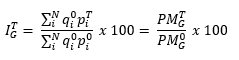
= average area of the crop "i" in the period of 2016

= average price in the year "T" for crop "i"

= average price in the base period of 2016 for crop "i"

= general index of land prices in the year "T"

= general average price in the year "T" with the quantities of the base period (2016)

= general average price in the base period (2016)

The percentual variation rates of a given crop class or group in the year "T" over the previous year (annual rate) are calculated with the following formula:


The effect of the variation of the prices of a crop type in the general index variation is the part of the index variation corresponding to said type of crop. Thus, the addition of effects is equal to the general index variation.

The formula used for the calculation of the effect is the following one:


where:

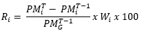
= average price of the crop class "i" in the year "T"

= average price of the crop class "i" in the year "T-1"

= general average price in the year "T-1"

= surface weighting per unit of crop "i"

Formula used to calculate the agricultural land rent

The general average prices in the year "T", from geographical or functional groups (both current and constant prices), are calculated with the following formula:

where:

N = number of geographical groupings or crop classes-uses that make up the national total.

Wi = superficial weighting, as much as one, of the geographical grouping or classes of crops-uses that make up the national total.

= average price in year "T" of the referred geographic group or type of crop-use "i".

The Statistical Units of the Autonomous Communities are responsible for collecting the prices of the representative classes in the selected municipalities-sites.


Calculation of indices, variation rates and effects

The formula used in the base 2016 to calculate the indices is that of Laspeyres, the same as in the previous bases, and the same as that used in most of the countries that produce land price indexes.

Using this formula we calculate the weighted arithmetic means of the elementary indices. The weights used remain fixed during the period of validity of the new base.

The general index corresponding to the year "T" is mathematically expressed as follows:

where:

N = number of crop types or usage

= average rent of the crop "i" in the period of 2016

= average rent in the year "T" for crop "i"

= average rent in the base period of 2016 for crop "i"

= general index of land rents in the year "T"

= general average rent in the year "T" with the quantities of the base period (2016)

= general average rent in the base period (2016)

The percentual variation rates of a given crop class or group in the year "T" over the previous year (annual rate) are calculated with the following formula:


The effect of the variation of the rent of a crop type in the general index variation is the part of the index variation corresponding to said type of crop. Thus, the addition of effects is equal to the general index variation.

The formula used for the calculation of the effect is the following one:


where:

= average rent of the crop class "i" in the year "T"

= average rent of the crop class "i" in the year "T-1"

= general average rent in the year "T-1"

= surface weighting per unit of crop "i"

18.6. Adjustment
  Land prices Land rents
Adjustment

Not applicable.

Not applicable.


19. Comment Top

No comment.


Related metadata Top


Annexes Top