
Since 2006, Eurostat has been carrying out the Land Use and Coverage Area frame Survey (LUCAS) every three years. LUCAS is used to identify changes in land use (for instance, agriculture, forestry, recreation or residential use) and land cover (for instance crops, grass, broad-leaved forest, or built-up areas).
LUCAS: what is going on?
The 2018 LUCAS survey has just started. Surveyors from the 28 Member States are visiting a total of 275 000 sites throughout the EU.
On this occasion, Eurostat has published a new overview page, which provides a user-friendly entry point to all our information and statistics on land cover and land use. From this page, you can also access over 270 000 points in Europe that are used for the LUCAS surveys and visualise the data and the photos taken from the sites themselves.
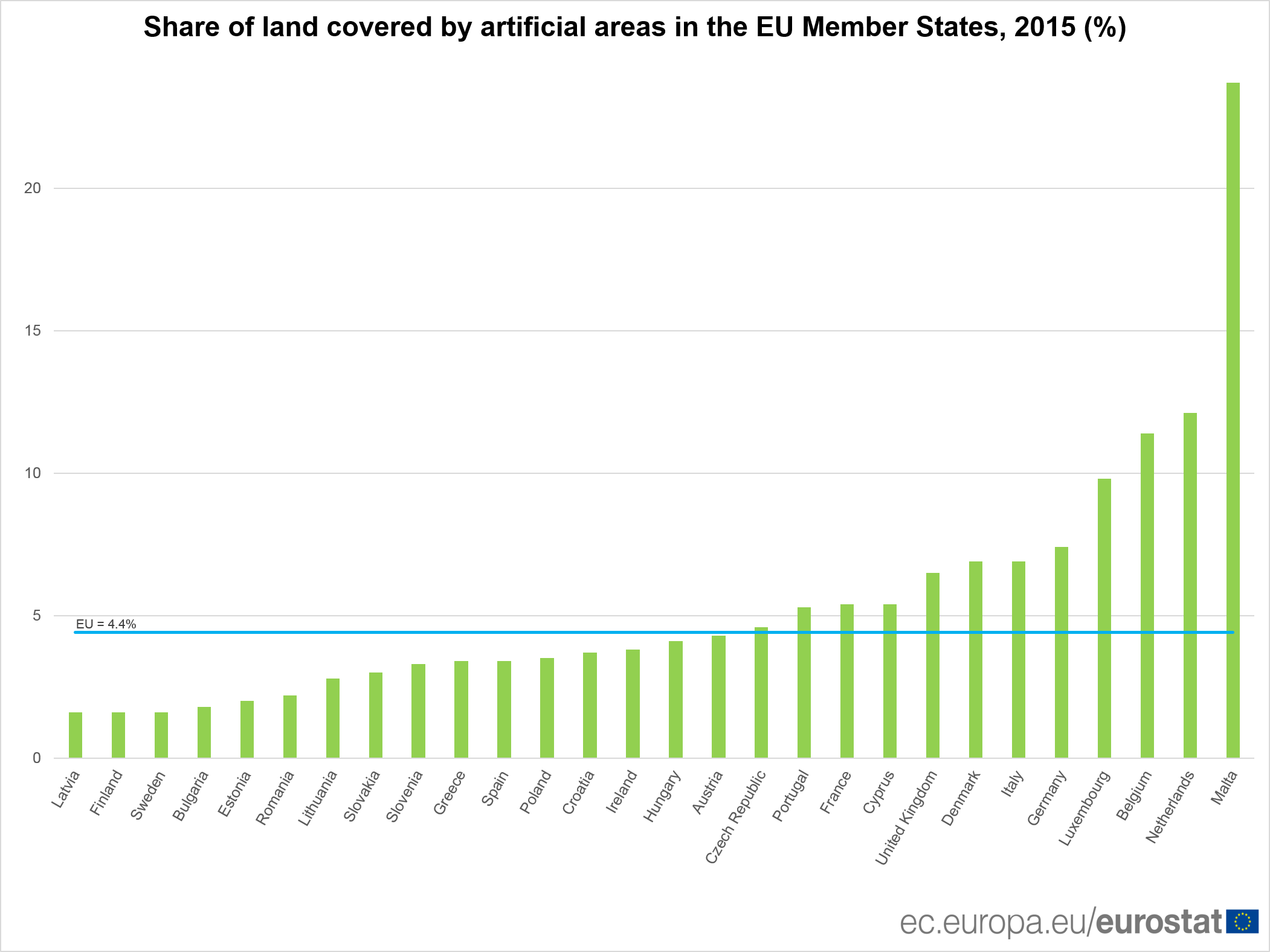
Proportion of man-made surfaces highest in Malta and Netherlands
You may discover that some 4% of the land in the European Union is covered by man-made surfaces such as built-up areas. This represents over 180 000 km2, which is roughly equivalent to twice the area of countries such as Hungary or Portugal. Compared with the size of the population, this means that in the EU there is nearly 370 m² of non-natural land per inhabitant.
Almost a quarter (23.7%) of Malta’s land is covered by artificial surfaces. As such, Malta has the highest proportion of land covered by man-made surfaces. Malta is followed by the Netherlands (12.1%), Belgium (11.4%), Luxembourg (9.8%) and Germany (7.4%). In contrast, 2% of or less of the land is covered by artificial surfaces in Latvia, Finland, and Sweden (all 1.6%), Bulgaria (1.8%) as well as Estonia (2%).
The source dataset can be found here.
However, this picture at national level does not fully reveal the disparities that exist among regions in the EU.
London and Brussels with highest shares of artificial areas at regional level
London in the United Kingdom, is the area with the highest artificial surface land coverage in the EU. The zones of Inner London - East (78.9%), Inner London - West (67.0%), Outer London - East and North East (60.1%), Outer London - South (54.8%) and Outer London - West and North West (51.9%) all have over half of their respective lands areas covered by artificial surfaces. The region of Brussels in Belgium is the only other region in the EU where non-natural surfaces make up the majority of its land use (52.5%).
Vienna (42.3%) in Austria, Greater Manchester (42.1%) in the UK, Bremen (38.9%) in Germany, the UK regions of West Midlands (37.3%) and Merseyside (36.8%), as well as the capital cities of Berlin (35.2%) in Germany and Prague (34.2%) in the Czech Republic, also had more than a third of total their land covered by man-made areas.
For more information please contact us: estat-user-support@ec.europa.eu.